
Magnitude 6.8 - NIAS REGION, INDONESIA
2006 May 16 15:28:26 UTC
Earthquake Details
| Magnitude | 6.8 |
|---|---|
| Date-Time |
= Coordinated Universal Time = local time at epicenter |
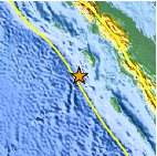
| Location | 0.081°N, 97.073°E |
| Depth | 16.2 km (10.1 miles) |
| Region | NIAS REGION, INDONESIA |
| Distances | 260 km (165 miles) SW of Sibolga, Sumatra, Indonesia 385 km (240 miles) WNW of Padang, Sumatra, Indonesia 615 km (380 miles) WSW of KUALA LUMPUR, Malaysia 1275 km (790 miles) WNW of JAKARTA, Java, Indonesia |
| Location Uncertainty | horizontal +/- 4.2 km (2.6 miles); depth +/- 10.2 km (6.3 miles) |
| Parameters | Nst=413, Nph=413, Dmin=662.7 km, Rmss=0.8 sec, Gp= 40°, M-type=teleseismic moment magnitude (Mw), Version=S |
| Source | USGS NEIC (WDCS-D) |
| Event ID | usmuaw |
- This event has been reviewed by a seismologist.
Did you feel it?
Report shaking and damage at your location. You can also view a map displaying accumulated data from your report and others.
Earthquake Summary

Felt Reports
Felt (VI) at Gunungsitoli. Felt (V) at Sibolga; (IV) at Banda Aceh and Padang; felt at Bukittinggi, Sumatra. Felt at Balakong, Butterworth and Kuala Lumpur, Malaysia. Also felt in Singapore. Ground cracks observed on Nias.
Earthquake Information for Asia
Earthquake Information for Indonesia
 Tsunami Information
- West Coast & Alaska Tsunami Warning Center
- Pacific Tsunami Warning Center
- Recent Tsunamis
- Tsunami Information Links
The earthquake locations and magnitudes cited in these bulletins are very preliminary, and may disagree with the more accurate USGS locations and magnitudes computed using more extensive data sets.


 Historic Moment Tensor Solutions
- Preliminary Earthquake Report
- U.S. Geological Survey, National Earthquake Information Center
World Data Center for Seismology, Denver
