
Magnitude 7.4 - KERMADEC ISLANDS REGION
2006 May 16 10:39:24 UTC
Earthquake Details
| Magnitude | 7.4 |
|---|---|
| Date-Time |
= Coordinated Universal Time = local time at epicenter |
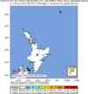
| Location | 31.527°S, 179.303°W |
| Depth | 151.6 km (94.2 miles) set by location program |
| Region | KERMADEC ISLANDS REGION |
| Distances | 55 km (35 miles) SW of L'Esperance Rock, Kermadec Islands 315 km (195 miles) SSW of Raoul Island, Kermadec Islands 785 km (485 miles) NE of Auckland, New Zealand 1185 km (730 miles) NNE of WELLINGTON, New Zealand |
| Location Uncertainty | horizontal +/- 7.9 km (4.9 miles); depth fixed by location program |
| Parameters | Nst=397, Nph=397, Dmin=284.6 km, Rmss=1.24 sec, Gp= 25°, M-type=teleseismic moment magnitude (Mw), Version=R |
| Source | USGS NEIC (WDCS-D) |
| Event ID | usmuah |
- This event has been reviewed by a seismologist.
Did you feel it?
Report shaking and damage at your location. You can also view a map displaying accumulated data from your report and others.
Earthquake Summary


Felt Reports
Felt (III) at Christchurch and Wellington, New Zealand. Also felt at Auckland, Gisborne, Hastings, Napier, Tauranga and Wanganui, New Zealand. Also felt on Kapiti Island, New Zealand.
 Tsunami Information
- West Coast & Alaska Tsunami Warning Center
- Pacific Tsunami Warning Center
- Recent Tsunamis
- Tsunami Information Links
The earthquake locations and magnitudes cited in these bulletins are very preliminary, and may disagree with the more accurate USGS locations and magnitudes computed using more extensive data sets.


 Historic Moment Tensor Solutions
- Preliminary Earthquake Report
- U.S. Geological Survey, National Earthquake Information Center
World Data Center for Seismology, Denver
