
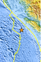
Magnitude 6.7 - VANCOUVER ISLAND, CANADA REGION
2004 November 2 10:02:12 UTC

Earthquake Details
| Magnitude | 6.7 (Strong) |
|---|---|
| Date-Time |
= Coordinated Universal Time = local time at epicenter |
| Location | 49.305°N, 128.781°W |
| Depth | 10 km (6.2 miles) set by location program |
| Region | VANCOUVER ISLAND, CANADA REGION |
| Distances | |
| Location Uncertainty | horizontal +/- 4 km (2.5 miles); depth fixed by location program |
| Parameters | Nst=257, Nph=257, Dmin=381.4 km, Rmss=1.18 sec, Gp= 65°, M-type=teleseismic moment magnitude (Mw), Version=R |
| Source | USGS NEIC (WDCS-D) |
| Event ID | usqial |
- This event has been reviewed by a seismologist.
Did you feel it?
Report shaking and damage at your location. You can also view a map displaying accumulated data from your report and others.


- Preliminary Earthquake Report
- U.S. Geological Survey, National Earthquake Information Center
World Data Center for Seismology, Denver
