|
|


|
Our Service Area
The NWS San Joaquin Valley County Warning and Forecast Area (CFWA) includes a large portion of the central California interior. Our CWFA lies between the
crests of the Diablo Range and the Sierra Nevada from Merced and Mariposa Counties south through the Tehachapi Mountains, just beyond Bakersfield. It also includes
all of Yosemite National Park and the Kern County portion of the Mojave desert. Elevations vary from only 90 feet above sea level near the Merced County line,
to 14,495 feet at the peak of Mt. Whitney (the tallest mountain in the contiguous United States). Our service area includes valley, mountain, and desert climates,
divisible into six distinct geographic areas and eleven forecast zones...
WEST CENTRAL SAN JOAQUIN VALLEY
(Zone 89) |
Merced County west of the San Joaquin River and Fresno County west of the San Joaquin and Kings Rivers. |
EAST CENTRAL SAN JOAQUIN VALLEY
(Zone 90) |
Merced County east of the San Joaquin River; Madera County east of the San Joaquin River and up to the 1000 foot elevation of the Sierra Nevada; Fresno County east of the San Joaquin and Kings Rivers and up to the 1000 foot elevation of the Sierra Nevada. |
SOUTHWESTERN SAN JOAQUIN VALLEY
(Zone 91) |
All of Kings County; Kern County southwest of a line from the Kings/Tulare/Kern County boundary southeast to Grapevine and up to the 1000 foot elevation of the Tehachapi Mountains. |
SOUTHEASTERN SAN JOAQUIN VALLEY
(Zone 92) |
Tulare County up to the 1000 foot elevation of the Sierra Nevada; Kern County southeast of a line from the Kings/Tulare/Kern County boundary southeast to Grapevine and up to the 1000 foot elevation of the Sierra Nevada and the Tehachapi Mountains. |
MARIPOSA, MADERA, AND FRESNO COUNTY FOOTHILLS
(Zone 93) |
Mariposa, Madera, and Fresno Counties between the 1000 foot and the 4000 foot elevation of the Sierra Nevada. |
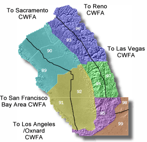 |
TULARE COUNTY FOOTHILLS
(Zone 94) |
Tulare County between the 1000 foot and 4000 foot elevation of the Sierra Nevada. |
KERN COUNTY MOUNTAINS
(Zone 95) |
The Kern County portion of the Sierra Nevada and the Tehachapi Mountains above 1000 feet on the San Joaquin Valley side and above 3000 feet on the Mojave Desert side. |
SIERRA NEVADA FROM YOSEMITE TO KINGS CANYON
(Zone 96) |
Mariposa, Madera, and Fresno Counties from the 4000 foot elevation and above in the Sierra Nevada. |
TULARE COUNTY MOUNTAINS
(Zone 97) |
Tulare County from the 4000 foot elevation and above in the Sierra Nevada. |
INDIAN WELLS VALLEY
(Zone 98) |
Kern County north of the crest of the El Paso Mountains and east of the 3000 foot elevation of the Sierra Nevada on the Mojave Desert side. |
SOUTHEASTERN KERN COUNTY DESERT
(Zone 99) |
Kern County south of the crest of the El Paso Mountains and east of the 3000 foot elevation of the Sierra Nevada and Tehachapi Mountains on the Mojave Desert side. |
Several recreational areas lie within the service area...
Demographics of the public service/forecast area are as follows, using 1994 census data...
| County |
Population |
Area (mi2) |
| Fresno |
737,289 |
6017.9 |
| Kern |
617,528 |
8162.0 |
| Kings |
113,089 |
1391.6 |
| Madera |
107,004 |
2153.4 |
| Mariposa |
15,772 |
1462.9 |
| Merced |
194,407 |
1372.0 |
| Tulare |
346,843 |
4839.4 |
| Yosemite Nat'l Park |
n/a |
1200.0 |
| Total |
2,035,226 |
26,599.2 |
Most of the economy of the service area is related to agriculture. However, many jobs are related to oil production, forestry, and aerospace. Lemoore Naval Air Station, China Lake Naval Weapons Center, and Edwards Air Force Base are also major employers in the service area.
|
|
|
|
Webmaster
US Dept of Commerce
National Oceanic and Atmospheric Administration
National Weather Service
San Joaquin Valley Weather Forecast Office
900 Foggy Bottom Road
Hanford, CA 93230-5236
Tel: (559) 584-3752
|
Disclaimer
Information Quality
Credits
Glossary |
Privacy Policy
Freedom of Information Act
About Us
Career Opportunities
|
National Weather Service Mission: "The
National Weather Service (NWS) provides weather,
hydrologic, and climate forecasts and warnings for
the United States, its territories, adjacent waters
and ocean areas, for the protection of life and
property and the enhancement of the national economy.
NWS data and products form a national information
database and infrastructure which can be used by
other governmental agencies, the private sector,
the public, and the global community." |
|
|


