| Event Type |
Details |
  - Tsunami Information Statement (high) - Tsunami Information Statement (high)
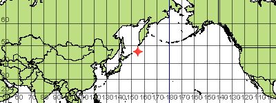 | 2009/01/15 17:49:39 (UTC)
Preliminary Magnitude: 7.5
Latitude: 46.9 Longitude: 155.2
Location: east of the Kuril Islands, Russia
204177 1 |
- Tsunami Information Statement (high)
 | 2009/01/15 07:27:23 (UTC)
Preliminary Magnitude: 6.8
Latitude: -22.6 Longitude: 170.5
Location: in the Loyalty Islands region
200444 1 |
- Tsunami Information Statement (low)
 | 2009/01/13 22:39:56 (UTC)
Preliminary Magnitude: 3.1
Latitude: 60.893 Longitude: -146.802
Location: 20 miles/32 Km SW of Valdez, Alaska
188639 1 |
- Tsunami Information Statement (low)
 | 2009/01/11 01:06:00 (UTC)
Preliminary Magnitude: 3.7
Latitude: 34.32 Longitude: -116.956
Location: 40 miles/64 Km S of Barstow, California
163596 1 |
- Tsunami Information Statement (low)
 | 2009/01/09 11:35:01 (UTC)
Preliminary Magnitude: 4.6
Latitude: 51.89 Longitude: -176.027
Location: 30 miles/48 Km E of Adak, Alaska
150090 1 |
- Tsunami Information Statement (high)
 | 2009/01/03 22:33:45 (UTC)
Preliminary Magnitude: 7.5
Latitude: -0.7 Longitude: 133.4
Location: in the Irian Jaya region, Indonesia
102202 1 |
- Tsunami Information Statement (high)
 | 2009/01/03 19:43:59 (UTC)
Preliminary Magnitude: 7.8
Latitude: -0.7 Longitude: 132.8
Location: in the Irian Jaya region, Indonesia
101183 1 |
- Tsunami Information Statement (low)
 | 2009/01/02 14:17:13 (UTC)
Preliminary Magnitude: 5.2
Latitude: 58.418 Longitude: -152.1
Location: 45 miles/72 Km NE of Kodiak City, Alaska
90583 1 |
- Tsunami Information Statement (low)
 | 2009/01/02 12:36:04 (UTC)
Preliminary Magnitude: 5.1
Latitude: 52.558 Longitude: -179.217
Location: 105 miles/169 Km NE of Amchitka, Alaska
89976 1 |
- Tsunami Information Statement (low)
 | 2008/12/28 07:13:10 (UTC)
Preliminary Magnitude: 4.6
Latitude: 62.351 Longitude: -150.967
Location: 30 miles/48 Km W of Talkeetna, Alaska
44839 1 |
- Tsunami Information Statement (low)
 | 2008/12/28 05:17:05 (UTC)
Preliminary Magnitude: 4.6
Latitude: 32.299 Longitude: -115.485
Location: 35 miles/56 Km S of El Centro, California
44142 1 |
- Tsunami Information Statement (low)
 | 2008/12/27 14:50:27 (UTC)
Preliminary Magnitude: 4.8
Latitude: 53.484 Longitude: -163.542
Location: 125 miles/201 Km SW of Cold Bay, Alaska
38942 1 |
- Tsunami Information Statement (low)
 | 2008/12/25 08:12:01 (UTC)
Preliminary Magnitude: 5.8
Latitude: 49.072 Longitude: -128.313
Location: 95 miles/153 Km SW of Port Alice, British Columbia
19272 1 |
- Tsunami Information Statement (high)
 | 2008/12/20 10:29:24 (UTC)
Preliminary Magnitude: 6.5
Latitude: 36.5 Longitude: 142.6
Location: off the east coast of Honshu, Japan
976896 1 |
- Tsunami Information Statement (low)
 | 2008/12/18 17:13:47 (UTC)
Preliminary Magnitude: 5.0
Latitude: 18.797 Longitude: -69.392
Location: 155 miles/249 Km NW of Mayaguez, Puerto Rico
962042 1 |
- Tsunami Information Statement (low)
 | 2008/12/13 19:55:43 (UTC)
Preliminary Magnitude: 4.5
Latitude: 60.829 Longitude: -150.815
Location: 40 miles/64 Km SW of Anchorage, Alaska
919814 1 |


