weather.gov
NOAA's National Weather Service
Aviation Weather Center
Home
News
Organization
Search
Local forecast by
"City, St" or Zip Code
Advisories
SIGMET/AIRMET
»
Java Tool
US (CONUS)
AWC Oceanic
Center Weather
Forecasts
Convection
»
Convective SIGMETs
CCFP
NCWF Java Tool
NCWF Loop
Convective Outlook
Convective Watches
Mesoscale Discussion
Turbulence
Icing
Winds/Temps
»
Winds/Temps Text
Winds/Temps Images
Prog Charts
»
High-Level (250-630)
Mid-Level (100-450)
Low-Level (SFC-240)
Surface
TAF / FA
»
Area Forecasts
TAF Java Tool
TAF Request Forms
Observations
PIREPs
»
PIREP Java Tool
PIREP Request Forms
METARs
»
METAR Java Tool
METAR Request Form
Radar
»
Site Radar
United States Radar
Satellite
»
United States
International
Java Tools
»
FPT Application
Flight Path Tool
AIR/SIGMETs
Convection
TAFs
PIREPs
METARs
Related Information
Home
»
AWC Home
ADDS Home
Flight Folder
Standard Briefing
Aviation Testbed
Aviation Links
Contact Us
FAQ
Feedback
»
AWC Feedback
ADDS Feedback
Site Information
»
AWC Site Info
ADDS Site Info
AWC Home
>
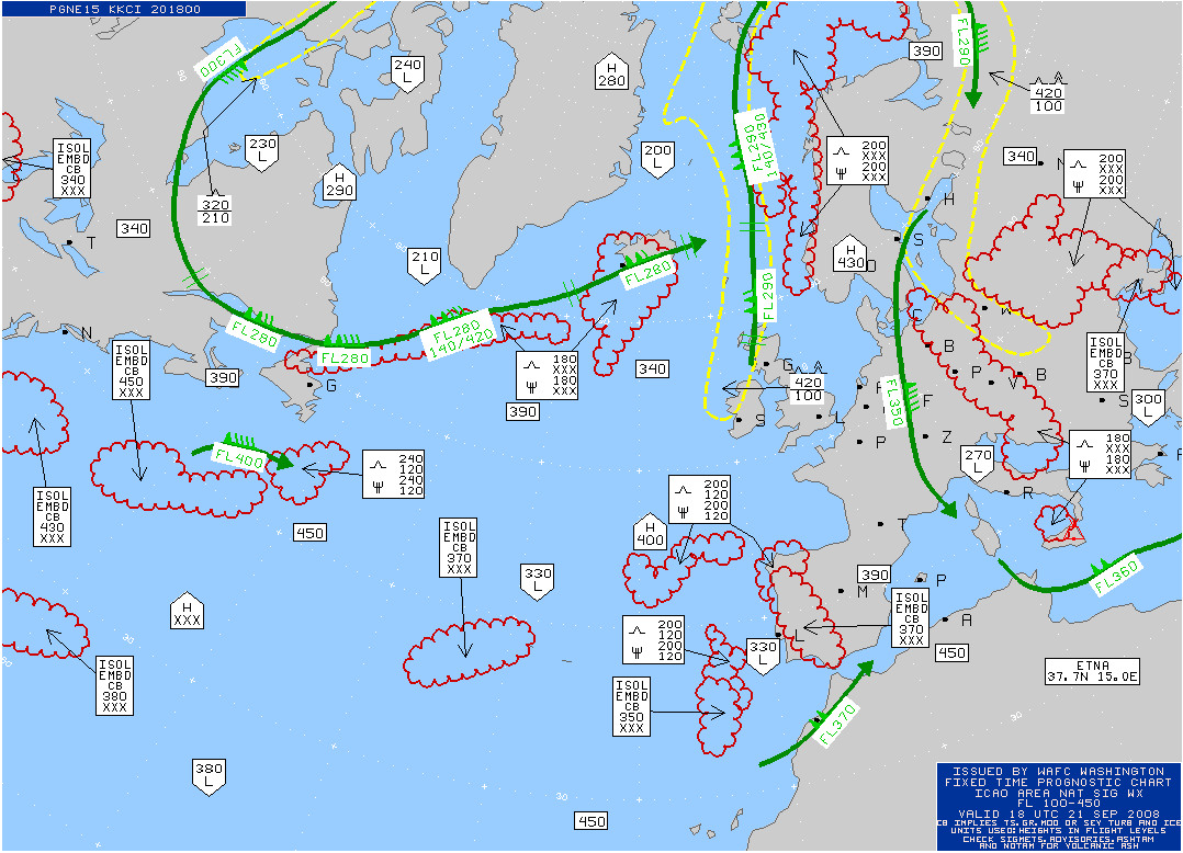
Mid SIGWX
Mid Level SIGWX Charts
FYI/Help
Click on Image to expand
Issue Time
Product Update
Valid at 00Z
08Z
07:46z 09/21
Valid at 06Z
14Z
13:46z 09/21
Valid at 12Z
20Z
19:48z 09/21
Valid at 18Z
02Z
01:47z 09/21
Turbulence
Icing
Convection
Winds/Temps
Progs
Java Tools
METARs
TAFs
PIREPs
SIGMET/AIRMET
Satellite
Radar
1
Page loaded:
20:16 UTC
01:16 PM Pacific | 02:16 PM Mountain | 03:16 PM Central | 04:16 PM Eastern
NOAA's
National Weather Service
National Centers for Environmental Prediction
Aviation Weather Center
7220 NW 101st Terr., Room 118
Kansas City, MO 64153-2371
Contact AWC Internet Services
Page last modified: February 12, 2008
Disclaimer
Credits
Glossary
Privacy Policy
About Us
Career Opportunities


