 This tool provides all of the features of the old Flight Path Tool applet
and more. It still allows you to view data along your route of flight.
You can still view icing, turbulence, temperature, winds, humidity, AIRMETs,
METARs, TAFs, etc. both horizontally and vertically. Now, however, you get
many more features not available in the applet. In the future, we'll be adding
even more features to the application but not to the applet. Take a look.
This tool provides all of the features of the old Flight Path Tool applet
and more. It still allows you to view data along your route of flight.
You can still view icing, turbulence, temperature, winds, humidity, AIRMETs,
METARs, TAFs, etc. both horizontally and vertically. Now, however, you get
many more features not available in the applet. In the future, we'll be adding
even more features to the application but not to the applet. Take a look.
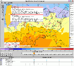
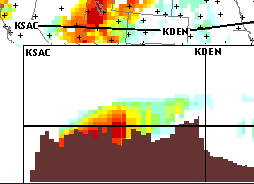 This tool allows you to view data along your route of flight as the graphic to
the right shows. You simply click to enter points along the route and can
view icing, temperature, winds, humidity, etc. both horizontally and
vertically. A tutorial
for the FPT is available and will open in a separate browser window.
This tool allows you to view data along your route of flight as the graphic to
the right shows. You simply click to enter points along the route and can
view icing, temperature, winds, humidity, etc. both horizontally and
vertically. A tutorial
for the FPT is available and will open in a separate browser window.
Caution, the Flight Path Tool
is a Java Applet which is large (approx. 350 KB).
For slow internet connections (28.8 to 56K modems), it will likely take a few
minutes to load. We think you'll find the wait worthwhile.
Internet Explorer users please read this
very important message.
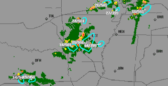 The National Convective Weather Forecast (NCWF) product contains a convective
hazard detection and 1-hour forecast. The current hazard field is colored
green to red for increasingly strong convection and the 1-hour forecast
hazard region is outlined with cyan polygons.
The National Convective Weather Forecast (NCWF) product contains a convective
hazard detection and 1-hour forecast. The current hazard field is colored
green to red for increasingly strong convection and the 1-hour forecast
hazard region is outlined with cyan polygons.
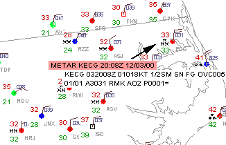 The METARs Java Tool allows users to view METARs graphically and textually
at the same time with only the variables that you desire. You can zoom into
particular regions, turn on temperature, weather, and winds, check ceiling
height and visibility. The tool is remarkably configurable.
The METARs Java Tool allows users to view METARs graphically and textually
at the same time with only the variables that you desire. You can zoom into
particular regions, turn on temperature, weather, and winds, check ceiling
height and visibility. The tool is remarkably configurable.
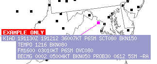 This tool provides users with a quick interface to retrieve text-format
Terminal Aerodrome Forecasts (TAFs) for a particular region. Simply zoom into
your flight area and quickly read the TAFs for departure, destination, and
alternate airports.
This tool provides users with a quick interface to retrieve text-format
Terminal Aerodrome Forecasts (TAFs) for a particular region. Simply zoom into
your flight area and quickly read the TAFs for departure, destination, and
alternate airports.
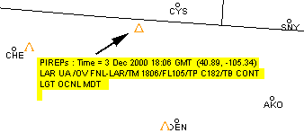 The PIREP Tool allows users to view PIREPs graphically and textually
at the same time and provides map overlays and zooming capability. You can
also remove displayed PIREPs for particular altitude ranges if, for instance,
you do not care about turbulence above 20,000 feet.
The PIREP Tool allows users to view PIREPs graphically and textually
at the same time and provides map overlays and zooming capability. You can
also remove displayed PIREPs for particular altitude ranges if, for instance,
you do not care about turbulence above 20,000 feet.
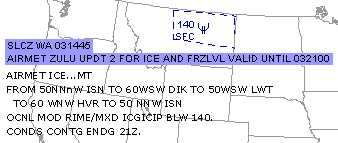 The AIR/SIGMETs Tool allows users to view AIRMETs graphically and textually
at the same time and provides map overlays and zooming capability. You can
also remove displayed AIRMETs for particular altitude ranges if, for instance,
you do not care about icing above 14,000 feet.
The AIR/SIGMETs Tool allows users to view AIRMETs graphically and textually
at the same time and provides map overlays and zooming capability. You can
also remove displayed AIRMETs for particular altitude ranges if, for instance,
you do not care about icing above 14,000 feet.
|

