
|
|
Fisheries-Oceanography Coordinated Investigations
|

FOCI PI Meeting Minutes - 13 May 1999
ATTENDING
Ned Cokelet, Al Hermann,
Art Kendall, Lynn Long (rapporteur), Allen Macklin, Bern Megrey,
Jeff Napp, Ron Reed, Phyllis Stabeno
ANNOUNCEMENTS
-
Al Hermann has created new 3D realizations
from the Shelikof Strait circulation/IBM model. All interested persons
are invited to stop by his office (3/2071) to view them.
-
SEBSCC and the Inner Front Study
are considering holding a joint PI meeting in Seattle later this
year. The purpose of the meeting would be to convene individual project
sessions, a joint "Status of the Bering Sea" meeting, and to plan for a
special journal edition on the southeastern Bering Sea. Potential dates
for the meeting are Monday through Wednesday, November 8 - 10, 1999.
George Hunt and Jeff Napp have proposed a special session for the next AGU/ASLO meeting in February 2000 to be held in San Antonio, TX. The session is called "Weather and the Amount and Fate of Production in the Ocean." It will be appropriate for papers dealing with recent weather-induced or short-term climate-induced changes in the Bering Sea ecosystem, as well as in other regions that have GLOBEC-like programs.
FIELD SEASON
-
Phyllis Stabeno discussed the Miller
Freeman late April mooring cruise (MF99-05). Figure
1 shows the cruise track. Many of the recovered instruments showed
evidence of considerable biological fouling and corrosion. The ADP at mooring
2 failed to release from its anchor. Another attempt will be made in September.
At Pribilof Canyon, two current meters and a Seacat were not found, but
may have been recovered by a fishing boat. Sea ice was present on the southeastern Bering Sea shelf into May this year, much later than normal. In early May, a finger of ice advanced southward across
the shelf, hitting mooring 2 and moving it about 7 kilometers to the south-southeast. The mooring buoy and meteorological tower were inspected visually during the following cruise (MF99-06) and did not appear to be damaged.
The instruments in the Freeman's sea chest appear to be working well, providing
salinity, temperature, and chlorophyll a (fluorescence) data. Of particular interest
were fluorescence peaks at the ice edge (Figure 2). These were noted when the ship entered and exited the ice.
High fluorescence was also noted along the peninsula during this cruise
and the next.
-
Jeff Napp reported on the next cruise
aboard the Freeman (MF99-06) in early May. The purpose of the cruise was to collect NPZ samples for the SEBSCC monitoring study and samples for nutrient dynamics, primary productivity, and copepod egg production studies. Plankton samples for stable isotope analyses to dissect the marine food web were also collected. Figure 3 shows the stations visited during the cruise. On the southeastern Bering Sea shelf (stations 1 5 at Mooring 2), the water was cold (-0.6 deg C), well mixed, and full of large centric diatoms. Inorganic nitrogen was still plentiful enough to support phytoplankton growth. Fluorescence and stratification increased along the 70-m isobath between the southeast (Mooring 2) and northwest (Mooring 4) monitoring stations. At the northwest site, the water was colder at the surface, fluorescence was higher, but inorganic nitrogen was almost depleted. This indicates that the spring bloom was finished, barring significant wind mixing. An unexpected finding was large numbers of oceanic and outer shelf domain (osd) plankton at the northwest cluster of monitoring stations. This implies that there was large-scale, cross-shelf transport. Many pollock eggs were found at stations between the Pribilof Islands. Water properties along the northeastward cross-shelf transect from the slope past Mooring 3 to Mooring 2 showed the water column was stratified in the osd with surface temperatures of 2 deg C and measurable quantities of inorganic nutrients. Monitoring ended at Mooring 2 where the water had cooled to 1.6 deg C by northerly winds and ice. The surface portion of Mooring 2 was visually inspected (after the ice departed), and ground-truth samples were collected. Before concluding the cruise, a bongo transect, not shown in Figure 3, was established orthogonal to the Alaska Peninsula just northeast of Amak Island to collect larval pollock for otoliths and genetic studies. High concentrations were found at the two most inshore stations.
-
Separating the mooring and sampling
cruises proved to be very advantageous. It freed time to deal with
problem moorings and allowed biologists to revisit a site during a cruise,
repeating measurements over time with the opportunity to note significant
changes.
-
Satellite-tracked drifters deployed
this spring in the eastern Bering Sea (Figure 4) show
weak flow on the shelf and east of Unimak Pass, unorganized flow in the
basin, and a clockwise rotating eddy near mooring site 6.
-
The first Wecoma cruise went
well, although there were some problems with the new Niskin bottles.
A design flaw is suspected.
-
Art Kendall, Jeff Napp, Ned Cokelet,
Mark Koehn, and Michele Bullock contributed to plans for the new NOAA fisheries
research vessel. The plans are posted on the 1st floor of building
4, and copies can be obtained from Dan Twohig (206 526-4166; Dan.Twohig@noaa.gov).
The proposed launch date for the ship is 2003.
-
The current Miller Freeman science
party is investigating greenbelt water properties, midwater ecology, and
shelf-slope currents and transfer processes.
NEXT MEETING
The next FOCI PI meeting
will be held at 10 a.m., June 10, 1999, in the AFSC Director's Conference
Room (4/2143). Please submit to Allen Macklin, no later than the day before
the meeting, agenda items and fax-ready copies of figures or handouts that
you intend to present at the next meeting.
CORRECTIONS
Mail corrections and addenda
to the FOCI Coordinator.
RETURN TO Minutes
selection

Figure 1. Cruise track (red) progressing counterclockwise from
Dutch Harbor for the April mooring cruise aboard the NOAA Ship Miller
Freeman, April 21 to May 1, MF99-05.
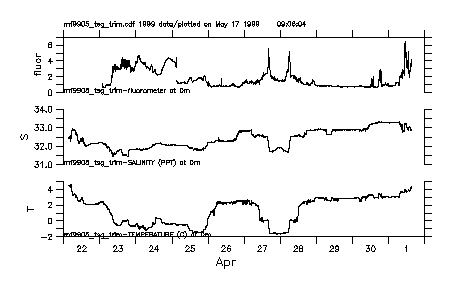
Figure 2. Plots of fluorescence, salinity, and sea surface temperature
from the Miller Freeman's seachest during MF99-05. On the
afternoon of 27 April, the ship entered the marginal ice zone north of
the Pribilof Islands, exiting about eighteen hours later.

Figure 3. Stations occupied during MF99-06.

Figure 4. Tracks of satellite-tracked drifters launched in late
winter and spring 1999. The gold track shows an eddy northwest
of Unalaska Island.