Geodesy
|
To some extent, geodesy is the study of the shape of the Earth. But it is also the study of how to find precise locations on the planet. As it relates to the study of sea level, geodesy becomes vital. The Earth is not a perfect shape and is constantly changing. Only through a very carefully constructed system of analysis can scientists achieve the necessary accuracy about the planet's shape (the so-called 'geoid') to make measurements of sea level from space. In this animation we look at how a fleet of ground based lasers and the Global Positioning Satellite fleet contribute to a mathematically representative picture of the Earth.
|
|

|
|
Illusration of ground-based lasers and Global Positioning satellites measuring the shape of the Earth.
Duration: 24.0 seconds
Available formats:
320x240 (30 fps)
MPEG-1
3 MB
320x240
PNG
119 KB
720x486
Frames
720x480 (29.97 fps)
MPEG-2
16 MB
640x480 (29.97 fps)
MPEG-4
8 MB
320x240 (30 fps)
X-FLV
847 KB
How to play our movies
|
|
|
|
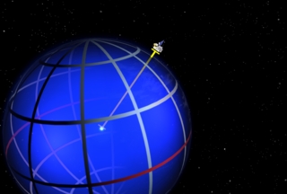
High resolution print still that illustrates the measurement determining the geoid.
Available formats:
3000 x 2025
TIFF
4 MB
320 x 216
JPEG
74 KB
160 x 80
PNG
24 KB
80 x 40
PNG
15 KB
|
|
|
|
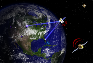
High resolution print still that illustrates ground based lasers and Global Positioning satellites.
Available formats:
3000 x 2025
TIFF
8 MB
320 x 216
PNG
106 KB
|
|
|
|
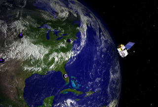
This picture represents a group of ground based laser rangefinders and the
JASON-1 satellite in orbit.
Available formats:
3000 x 2025
TIFF
14 MB
320 x 216
PNG
107 KB
|
|

|
|
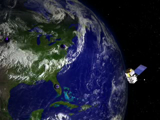
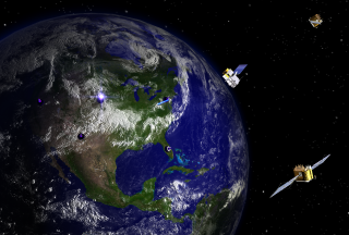
This picture represents a group of ground based laser rangefinders, the JASON-1 satellite, and two GPS satellites in orbit. These elements contribute to global geodesy measurements.
Available formats:
3000 x 2025
TIFF
12 MB
320 x 216
PNG
92 KB
|
|
|
Back to Top
|

