 Winter storms have the capability to completely immobilize large areas of a state, and possibly several states simultaneously. Thus, winter weather warnings, watches, and advisories are issued for relatively large geographic areas of Kentucky and Indiana, rather than for one specific county or a small group of counties. Winter storms have the capability to completely immobilize large areas of a state, and possibly several states simultaneously. Thus, winter weather warnings, watches, and advisories are issued for relatively large geographic areas of Kentucky and Indiana, rather than for one specific county or a small group of counties.
By nature, different types of winter weather occur within a winter storm, and at varying intensities. Strong winds, extreme cold, accumulations of ice and heavy snow, and dangerous wind chills are typically what most affect our region. Winter storms may be deceptive because many deaths and injuries are indirectly related to the storm. People can be hurt or killed in traffic accidents on icy roads, while shoveling snow, or from hypothermia due to prolonged exposure to cold, etc.
 Current Regional Winter Weather Watches, Warnings, and Advisories Current Regional Winter Weather Watches, Warnings, and Advisories
Interactive Snowfall Maps
Road Reports
[ Kentucky ] 1-866-737-3767 or 511 instate [ Indiana ] 1-800-261-7623
Winter weather events are disseminated via the WSW WWUS43 KLMK weather product. A WSW is used to...
- Issue the initial watch, warning, or advisory,
- Change the type of product,
- Add or delete affected areas,
- Extend the cancellation time of the event,
- Update information pertaining to the watch, warning, or advisory, or
- Terminate the watch, warning, or advisory.
| Types of Products |
 |
|
|
|
|
If there is sufficient confidence that a major winter storm may cause a significant hazard to public safety, the information will be highlighted in the daily Hazardous Weather Outlook. Notification would generally be given three to seven days in advance of an event and would be updated as additional information becomes available.
The following winter weather advisories are the most common, and would primarily be issued for the first period of the seven day forecast. Advisories ALERT the public of situations that may cause inconvenience or difficulty to travelers, or for people who must be outdoors, but conditions generally do not pose a threat to life or property.
| Snow Advisory |
Used when snowfall amounts are below warning criteria, but nonetheless pose a hazard to the public. Issued for average snowfall amounts of less than 4". Forecast amounts would be 1-2", 1-3", 2-4", or around 3". |
| Winter Weather Advisory |
Used when a mixture of precipitation such as snow, sleet, and freezing rain or drizzle is expected, but will not reach warning criteria. If only freezing rain or freezing drizzle is expected, then the product would be issued as a Freezing Rain or Freezing Drizzle advisory. |
| The following winter weather watches and warnings are the most common, and WARN the public of a more serious winter weather situation that may seriously hinder travel across the state and could pose a serious threat to life or property. |
| Winter Storm Watch |
Issued if there is a threat for heavy snow or sleet, significant accumulations of freezing rain or freezing drizzle, or any combination of these. Issued for the second and third periods of a forecast, i.e. 12 to 36 hours in advance of the event. Generally not issued for the fourth period of a forecast. The definition of heavy snow in Kentucky is 4" or more in 12 hours, or 6" or more in 24 hours. |
| Winter Storm Warning |
Issued if there is a high probability that severe winter weather will occur, such as heavy snow or sleet, significant accumulations of freezing rain or freezing drizzle, or any combination of these. Issued normally for the first period forecast, i.e. less than or equal to 12 hours in advance of the event. A winter storm warning may be extended into the second period of the forecast if necessary. |
| Heavy Snow Warning |
Issued when heavy snowfall is expected (see above), and accompanied by moderate or heavy snowfall rates. |
| Blizzard Warning |
Issued for winter storms with sustained winds or frequent gusts of 35 mph or greater, and considerable falling and/or blowing snow reducing visibilities to 1/4 mile or less. These conditions should last for 3 hours or longer. |
| Wind Chill Warning |
Issued when wind chill temperatures are expected to reach -25°F or colder, with a minimum wind speed of about 10 mph. Wind Chill Warnings are disseminated via the NPW WWUS45 KLMK weather product. |
|
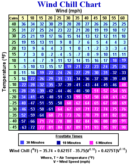
| Wind Chill Index |
|
|
|
|
 During the winter months, it's not only the actual temperature that we worry about, but the wind chill temperature as well. The Wind Chill Index is based on the rate of heat loss from exposed skin caused by the combined effects of wind and cold. It is how cold the air feels to our skin. During the winter months, it's not only the actual temperature that we worry about, but the wind chill temperature as well. The Wind Chill Index is based on the rate of heat loss from exposed skin caused by the combined effects of wind and cold. It is how cold the air feels to our skin.
As the wind increases, heat is carried away from the body at an accelerated rate. The following is a chart that graphically correlates the properties of Air Temperature and Wind Speed.
|
| Other Resources |
|
|
|
|
|