|
|
|
|
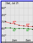
Maximum Heat Index Forecast for the next 7 days.
|
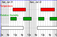
Hourly Heat Index Forecast for the next 7 days.
|
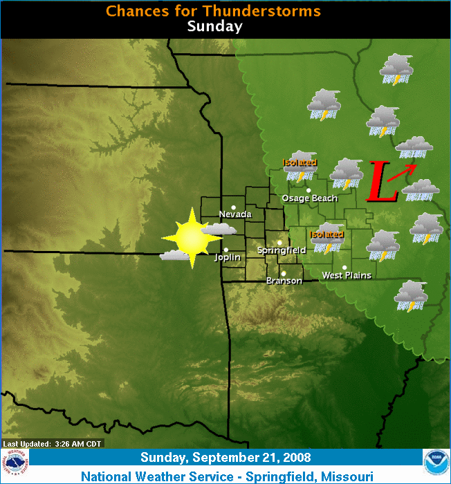 An upper level low will gradually track northeast. Isolated to scattered thunderstorms will be possible, primarily this afternoon east of Missouri Highway 5. |
Forecast Map 12 hr | | 24 hr | 36 hr | 48 hr Graphical Forecast 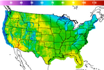 Local | Regional | National Heat Index Forecast  Precipitation Forecast  Day 1 | Day 2 | Day 3 |
| Products | ||
| Excessive Heat Watch/Warning/Advisory | Hazardous Weather Outlook | Zone Forecast | Hourly Weather | Forecast Discussion |
|
||
|
|
||
Click here for more Heat Index outlooks from the Hydrometeorological Prediction Center.
 |
Go to our Summer Weather Safety page for more information on how to safe in the sun.
Drink plenty of water or nonalcoholic fluids. Your body needs water to keep cool. Drink plenty of fluids even if you don't feel thirsty. Persons who (1) have epilepsy or heart, kidney, or liver disease, (2) are on fluid restrictive diets, or (3) have a problem with fluid retention should consult a physician before increasing their consumption of fluids.
Do not take salt tablets unless specified by a physician. Persons on salt restrictive diets should consult a physician before increasing their salt intake.
Spend more time in air-conditioned places. Air conditioning in homes and other buildings markedly reduces danger from the heat. If you cannot afford an air conditioner, spending some time each day (during hot weather) in an air conditioned environment affords some protection.
Don't get too much sun. Sunburn makes the job of heat dissipation that much more difficult. |
Slow down. Strenuous activities should be reduced, eliminated, or rescheduled to the coolest time of the day. Individuals at risk should stay in the coolest available place, not necessarily indoors.
Dress for summer. Lightweight, light-colored clothing reflects heat and sunlight, and helps your body maintain normal temperatures.
Put less fuel on your inner fires. Foods (like proteins) that increase metabolic heat production also increase water loss.
Do not drink alcoholic beverages.
|
||||||||||||||||||
|
THE SUMMER SEASON |
|||||||||||
| FIVE HIGHEST AVERAGE MONTHLY TEMPERATURES | FIVE LOWEST AVERAGE MONTHLY TEMPERATURES | ||||||||||
| JUNE | YEARS | JULY | YEARS | AUGUST | YEARS | JUNE | YEARS | JULY | YEARS | AUGUST | YEARS |
| 81.1 | 1952 | 85.4 | 1934 | 84.4 | 1936 | 66.8 | 1928 | 71.7 | 1950 | 68.8 | 1915 |
| 80.8 | 1953 | 84.8 | 1954 | 83.5 | 1938 | 67.2 | 1903 | 71.9 | 1905 | 71.1 | 1992 |
| 79.4 | 1934 | 84.2 | 1936 | 83.4 | 1983 | 68.3 | 1974 | 72.8 | 1906 | 72.3 | 1967 |
| 78.8 | 1914 | 83.9 | 1901 | 82.9 | 1980 | 68.5 | 1955 | 73.2 | 1924 | 73 | 1889 |
| 78.6 | 1911 | 83.8 | 1980 | 82 | 1912 | 68.6 | 1912 | 73.5 | 1967 | 73.2 | 1890 |
| Seasonal Records | ||||
| WARMEST | COLDEST | |||
| TEMP. | YEAR | TEMP. | YEAR | |
| 82.1 | 1936 | 71 | 1915 | |
| 81.9 | 1934 | 71.6 | 1950 | |
| 81.3 | 1954 | 71.8 | 1927 | |
| 80.7 | 1980 | 72.6 | 1906 | |
| 79.9 | 1901 | 72.7 | 1992 | |
NWS Heat Safety: http://www.nws.noaa.gov/om/heat/index.shtml
Missouri Department of Health: http://www.health.state.mo.us
NWS Heat Related Products
To advise you of the potential of excessive heat, your National Weather Service in Springfield will issue a:
Heat Advisory - Heat Index (HI) of 105º F and a minimum 24 hour HI in the middle 70s.
Excessive Heat Warning - Heat Index (HI) of 110º F and a minmum HI in the middle 70s for 48 hours . Warnings are also issued when the HI exceeds 105º F for 4 consecutive days
Hazardous Weather Outlook- Daily at 6 AM and 1 PM to highlight the potential of any hazardous weather over the next few days.