


Fire Weather Spot Forecast Requests Via the Internet:
Spot Forecasts are issued for prescribed burns, wildfires, spray projects, or any number of land management activities within our forecast area. Government agencies anywhere within our fire weather forecast area can request a spot forecast.
Click Here For A Spot Forecast
 Notes on using the spot forecast program.
Spot forecasts can also be obtained by phone or fax. See the latest Annual Operating Plan for phone numbers.
Fire Weather Annual Operating Plan (.pdf file requires Adobe Acrobat or Adobe Acrobat Reader)
Fire Weather Annual Operating Plan (MS Word Version)
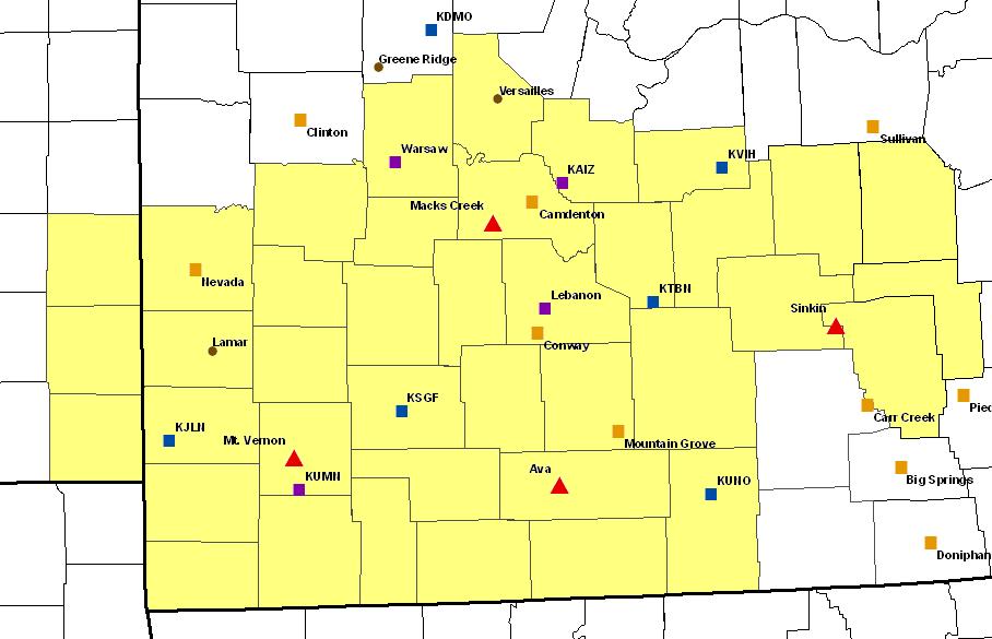
Click on one of the shaded counties below to retrieve the fire weather forecast for that county.
| |
Fire Weather Forecast Area: |
|
| |
 |
|
| |
|
|
| |
|
|
| |
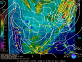 Current Weather Map With Satellite Imagery (from HPC) Current Weather Map With Satellite Imagery (from HPC) 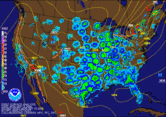 Current Weather Map With Radar Mosaic (from HPC) Current Weather Map With Radar Mosaic (from HPC) |
|
| |
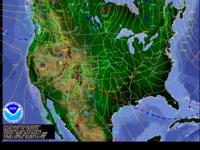 Short Range Forecast Maps (from HPC) Short Range Forecast Maps (from HPC) 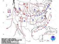 Forecast Days 3 to 7 (HPC) Forecast Days 3 to 7 (HPC) |
|
| |
|
|
| |
|
Area Observations
|
| Regional Observations (via ROMAN--Real-Time Observation Monitor and Analysis Network) |
| RAWS USA Climate Archive |
MesoWest (Univ. of Utah) |
| Meteorological Assimilation Data Ingest System (MADIS) |
Hourly Regional Weather Roundup (NWS Springfield) |
| Community Collaborative Rain, Hail and Snow Network (CoCoRaHS) |
NWS GIS Data |
|
|
| Ava (NFDRS) |
Sinkin (NFDRS) |
Macks Creek (NFDRS) |
Mt. Vernon (NFDRS) |
| Ashland |
Big Spring |
Carr Creek |
Clinton |
| Doniphan |
Farmington |
Sullivan |
State Line, KS |
|
Area Airport Observations (ASOS/AWOS)
|
| Missouri |
| Springfield ASOS |
Joplin ASOS |
Rolla/Vichy ASOS |
Osage Beach AWOS |
| West Plains ASOS |
Sedalia ASOS |
Farmington ASOS |
Ft. Leonard Wood ASOS |
| Lebanon AWOS |
Whiteman AFB ASOS |
Sullivan AWOS |
Piedmont AWOS |
| Neosho AWOS |
Warsaw AWOS |
Nevada AWOS |
Poplar Bluff ASOS |
|
|
| Grove, OK AWOS |
Parsons, KS ASOS |
Chanute KS ASOS |
Fort Scott KS AWOS |
|
|
| Rogers, AR AWOS |
Harrison, AR ASOS |
Flippin, AR AWOS |
Mountain Home, AR ASOS
|
| Bentonville, AR AWOS |
|
|
|
|
|
| Lamar |
Versailles |
Green Ridge |
Cook Station Crawford County |
| Mountain Grove |
|
|
|
|
|
| Near Arma, KS |
10 WSW Salem, MO |
|
|
|
|
| |
|
|
| |
|
Other Links
|
| National Fire and Aviation Management Page (includes Weather Information Management System (WIMS)) |
Wildfire Assessment System (Maps of Various Weather, Fuel Moisture, Drought, Burning Parameters, etc)
|
| National Interagency Fire Center |
| National Interagency Coordination Center |
| Eastern Area Coordination Center |
Eastern Area Seven Day Fire Potential Outlook |
| Rocky Mountain Area Coordination Center |
| Fire Consortia for Advanced Modeling of Meteorology and Smoke (FCAMMS) |
| Rocky Mountain Center/Research Center USFS |
| Mark Twain National Forest - Current Conditions |
| U.S. Forest Service Fire and Aviation Page |
| Missouri Department of Conservation Forestry / Wildfire In Missouri / Missouri Wildfire Statistics |
Healthy Forests and Rangelands - National Fire Plan
|
|
AIRNow.gov (Air Quality Monitoring Page)
|
| Firewise Communities |
|
Neighboring National Weather Service Office's Fire Weather Pages
|
| WFO Paducah, KY |
WFO Pleasant Hill, MO |
| WFO Little Rock, AR |
WFO St. Louis, MO |
| WFO Tulsa, OK |
WFO Wichita, KS |
|
|