|
NOAA Magazine || NOAA Home Page HURRICANE FORECASTERS SAY 6 TO 8 HURRICANES COULD THREATEN IN 2002 NOAA Expects Normal to Slightly Above Normal Atlantic Storm Activity
At today's news conference at NOAA's National Hurricane Center in Miami, Fla., officials also marked the start of the nationwide awareness campaign led by NOAA, the Federal Emergency Management Agency and storm-vulnerable states to increase preparedness and safety among residents. Recognizing the importance of these efforts, President George W. Bush signed a proclamation announcing May 19-25 as National Hurricane Awareness Week. Speaking on behalf of the President, U.S. Department of Commerce Deputy Secretary Sam Bodman said, "One of the most damaging, and potentially deadly weather events is a hurricane. Hurricanes have a devastating impact on our economy, causing billions of dollars in losses and damages, but the human toll can also be very high when people aren't prepared. President Bush asks all Americans in harm's way to be more vigilant about preparing for hurricanes in advance, rather than responding only when they threaten." In 2001, there were 15 named storms, nine of which became hurricanes. A normal Atlantic hurricane season typically brings an average of 10 tropical storms, of which six reach hurricane strength, with two classified as major. Above-normal activity has been observed during six of the last seven Atlantic hurricane seasons. The key climate patterns guiding this year's expected activity are long-term patterns of tropical rainfall, air pressure and higher temperatures of the Atlantic Ocean that are more conducive to hurricane development. These warmer ocean temperatures, combined with lower wind shear in the hurricane development region, have historically generated higher numbers of major hurricanes.
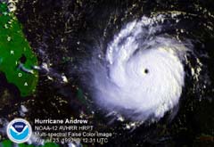
Lautenbacher said, "This is the fifth year that NOAA has provided this forecast and, based on our success with the previous four outlooks, we have growing confidence in our ability to outline how the hurricane season will shape up. Residents in hurricane-prone areas must keep up their guard since it only takes one hurricane to destroy a community and lives." Lautenbacher pointed to continuing improvements in technology and research enabling forecasters to produce the 2002 outlook. "Better data from NOAA's environmental satellites, better models, the latest supercomputers and an improved ability to monitor and understand global climate patterns are helping to create better long-term and short-term forecasts," Lautenbacher said. August 2002 marks the 10th anniversary of Hurricane Andrew, one of the nation's costliest hurricanes. Andrew hit Florida and Louisiana, claiming 26 lives and more than 125,000 homes. Storm damage exceeded $40 billion. "Since that time, NOAA has continued to make significant investments to enhance our forecasting and warning capabilities," added Lautenbacher. FEMA Region IV director Ken Burris said, "As we prepare for another hurricane season with an ever-growing population living in vulnerable coastal areas, we all share the responsibility of preventing the loss of life, and minimizing the damage to property from hurricanes." Max Mayfield, director of NOAA's National Hurricane Center
in Miami said, "The public hasn't seen a land-falling hurricane
in two seasons and we know from experience—out of sight
is out of mind. These are dangerous storms requiring the public
to take precautions now before the season starts." He recalled
hurricane-spawned disasters can occur any season. Hurricane Andrew,
in particular, developed during a season of below-normal hurricane
activity. Mayfield added, "We don't want people to be caught
off guard by a land-falling tropical storm or hurricane." The Atlantic Hurricane Outlook is a consolidated team effort consisting of NOAA's Climate Prediction Center, the Hurricane Research Division and the National Hurricane Center. NOAA meteorologists use a suite of high-tech tools to forecast tropical storms and hurricanes. Forecasters rely on information gathered by NOAA and U.S. Air Force Reserve personnel who fly directly into the storms in "hurricane hunting" aircraft, NOAA satellites and NEXRAD WSR 88D radars. NOAA's National Weather Service is the primary source of weather data, forecasts and warnings for the United States and its territories. The National Weather Service operates the most advanced weather and flood warning and forecast system in the world, helping to protect lives and property and enhance the national economy. Relevant Web Sites
|


