

| Climate of 2002/2003 North America Snow Season National Climatic Data Center, 6 June 2003 |

|
 Animated Image Animated Image |
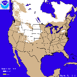
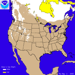
The image to the left shows the snow cover on October 31st 2002. In contrast to the generally increasing snowcover through the month across the continent, it was the warmest October in Alaska since 1938, and it is only the 8th time on record that Anchorage has had no snow in October. The image below shows snow totals for the Midwest for the month of October up to the 24th of the month. Up to 10 inches of snow fell across parts of the Midwest during the several days preceding the 24th.
|
| The first significant snow of the season came on the 21st of October in the upper Midwest, including Nebraska, North and South Dakota and especially Minnesota. Duluth, MN had its 8th snowiest October on record with a total of 6.3 inches for the month. Marquette, MI started its snow season with a monthly total of 17 inches, making it the 2nd snowiest October on record. The large October 2002 total for Marquette, in Michigan's Upper Peninsula, follows on the heels of a record-breaking seasonal total for the town last winter (2001/2002). Snow also fell early in October in the west with Ely, Nevada receiving its largest 24 hour October snowfall amount (12 inches) on record on October 1st, shattering the previous record of 6 inches, set in 1991.
See NCDC's snow monitoring page for the latest snow totals and the snow climatology pages for snow statistics for U.S.states and stations. |
 larger image |
|
 Animated Image
 |
The image to the left shows the snow cover on November 6th 2002. Click on the image to view an animation of daily snow cover throughout the month of November 2002. |
|
 Animated Image
 |
The image to the left shows the snow cover on December 6th 2002, after an early snowfall (described below) left several inches of snow over a large swath from Oklahoma to the Northeast. Click on the image to the left for an animation of snowcover throughout the month of December.
|
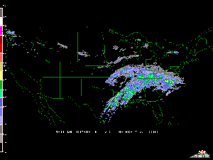 Radar Animation Courtesy UCAR |
An early season winter storm brought damaging ice accumulations to the Carolinas with significant accumulations of snow across the lower Ohio Valley, southern Appalachians and into the Northeast. During December 4-5, an expansive shield of snow and ice encompassed much of the eastern U.S., from the lower Ohio Valley, southern Appalachians and into the Northeast. Snow accumulations of 4-8 inches(10-20 cm) were common along the northern edge of the precipitation shield, while a significant accrual of glaze occurred in the Carolinas. The storm caused at least 17 fatalities, mostly from traffic accidents (CNN). |
|
After skies cleared on the 6th, enhanced satellite imagery depicted the extensive area of fresh snow cover, extending from the Oklahoma and Texas panhandles, eastward into the lower Ohio Valley. |
| A major winter storm affected much of the eastern United States during December 23-25, 2002. Significant accumulations of snow were reported from the Texas panhandle, through Oklahoma, Kansas, Missouri and northern Arkansas during the 23rd-24th, causing 12 deaths (Associated Press). Springfield, MO reported 33cm (13 inches) of snow, or 52 cm (20.5 inches) for the month, for a new December snowfall record. Snow spread eastward from parts of the Ohio Valley and into the Northeast on Christmas Day, with some locations experiencing the snowiest Christmas Day ever recorded. |  Larger image |
| See NCDC's snow monitoring page for the latest snow totals and the snow climatology pages for snow statistics for U.S.states and stations. The weekly hazards page also includes information on U.S. weather events. |
|
 Larger image
 |
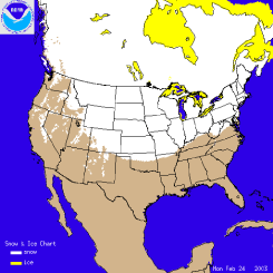
The image to the left shows the percent of average seasonal snow fall for stations across the continental U.S. Many of the stations were more than 25% below average across much the West and Midwest. Stations in the east received a greater percentage of their seasonal snow fall as of February 6th, however, even in the east, percentages of 50-75 percent of the long-term mean were common. The tracks of several winter storms are visible, (from paths of stations registering above average seasonal totals), such as a swath from northeastern Oklahoma through Missouri and Illinois to Indiana. Some higher than average percentages can also be found in the Carolinas where a storm system dumped up to 10 inches (25.4 cm) of snow across parts of North Carolina in January (more details below).
|
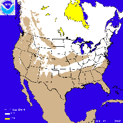
| The image to the right shows the snow cover on January 23rd 2003, after a large snowstorm (described below) left up to 10 inches (25.4 cm) of snow over a large area of the Southeast and Mid-Atlantic. Click on the image to the right for an animation of snowcover throughout the month of January.
|
 Animated image Animated image |
 Larger image
 |
The image to the left from NOAA's National Weather Service Northeast River Forecast Center shows snowfall totals in the Northeast for the first week of January 2003. Well over a foot (30.5 cm) of snow fell across almost the entire state of Massachusetts, and much of the rest of New England and New York. The snow was accompanied by sustained winds in excess of 30 mph (48.3 kph) in some coastal locations, with gusts reaching above 40 mph (64.4 kph). Some of the mountain towns in Massachusetts, such as Ashfield, Goshen, and Worthington had one and a half to two feet (46-61 cm) of snow on the 3rd and 4th. Further snow interrupted traffic and caused numerous problems in upstate New York over the weekend of the 11th and 12th of January. Over 50 inches (4 feet / 122 cm) of snow fell in parts of Osceola and Lewis counties - the result of cold air-amplified lake-effect snow from Lake Ontario.
|
| A winter storm brought significant accumulations of snow to parts of the U.S. Deep South, including the Carolinas, on the 23rd. Snowfall accumulations of 4 to 12 inches (10-30 cm) were common across areas of western and central North Carolina, as well as the Outer Banks. The Outer Banks usually escapes heavy snow due to the warm insulating water of the Atlantic Ocean around Cape Hatteras. Some of the heaviest snow fell between Forest City and Morganton in western North Carolina exceeding the area's seasonal snowfall totals in just a few hours according NOAA's National Weather Service Office in Greenville-Spartanburg, SC. |  larger image |
SPECIAL SNOW REPORT 2/18/03 Northeastern Snow Storm 2/16/03-2/17/03
|
 Larger image
 |
One of the largest snowstorms in many years brought paralyzing snow accumulations to the Northeast over the President's Day weekend (16th-17th February). The image to the left shows the snowfall totals for stations across the Northeast U.S for the 48 hours beginning at 7am (Eastern Standard Time) on the 16th until 7am on Tuesday 18th. Over 2 feet (61 cm) of snow fell in many locations (mainly on the 17th), with the major northeastern cities of Washington DC, New York City and Boston coming to a standstill while roads were cleared.
|
| The infrared satellite image to the right shows the storm as it tracked across the northeastern states on the 17th. The National Weather Service 24-hour snow totals can be seen by clicking to several text files of station data for many locations across New England, New York and New England and the mid-Atlantic. |  Larger image |
 Larger image
 |
The image to the left from NOAA's National Weather Service Northeast River Forecast Center shows snowfall totals in the Northeast for the snow event on the 16th and 17th February 2003. Well over a foot (30.5 cm) of snow fell across almost the entire state of Massachusetts, and much of the rest of southern New England and New York. However, the storm covered in snow an area from Kentucky to Connecticut on the 16th and 17th and at least 10 deaths have been attributed to the storm (Reuters). Some of the largest accumulations from the President's Day Storm occurred in and around New York City with Central Park receiving 19.8 inches (50.3cm) from the storm. This makes February 2003 the fourth snowiest February in Central Park with the total so far (as of the 18th) standing at 26.1 inches (66.3 cm) for February 2003. This total is also nearing the snowiest month of all time which was March 1896 with 30.5 inches (77.5 cm). Boston received a remarkable 27.5 inches (69.9 cm) of snow - the largest snowfall total for any storm in the city since records began.
|
The storm left portions of the Southeast contending with ice and sleet instead of snow, and travel conditions were dangerous across large portions of the Carolinas and Georgia over the President's Day weekend. Airport delays across the entire eastern seaboard left thousands of travelers stranded over the Sunday 16th-Tuesday 18th period.
Other Snow information for February: |
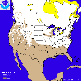
| The image to the right shows the snow cover on February 24th 2003, after a large snowstorm (described below) left up 10-20 inches (25-50 cm) of snow over a large area of Oklahoma, Missouri and Kansas. Click on the image to the right for an animation of snowcover throughout the month of February.
|
 Animated image Animated image |
 Larger image
 |
February 2003 was a snowy month for many locations especially in the eastern U.S. A series of winter storms brought snow to parts of the Northeast and Mid-Atlantic through the month, with the President's Day storm of the 16th and 17th of February being by far the most notable for the month and season in the Northeast. Oklahoma and parts of Missouri and Kansas have seen much above average snow for February (see map to the left) and the winter season. The Ohio Valley has also had a snowier than average February. Western snowpacks have also received some more snow this month, though most areas still remain below average for the season.
|
|
As much as a foot of snow fell on parts of southern Missouri and southeastern Kansas (see map to the right) on Sunday 23rd of February. The same storm left as much as 10-20 inches (25-50 cm) of snow in northern Oklahoma causing a 75 car pile-up on Interstate 44 (AP). The seasonal total for Springfield, MO through the end of February 2003 was around 35 inches (89 cm). The average seasonal total up to the end of February is less than 17 inches (43 cm), placing 2003 as the 4th snowiest season so far for Springfield. See NOAA's National Weather Service Forecast Office web-page for Springfield, Missouri for further information on this and other storms for the region. |
 Larger image
 |
|
 Larger image
 |
The image to the left shows the percent of average seasonal snow fall for stations across the continental U.S. Data is based on preliminary reports, final values will likely change for some stations. Many of the stations were more than 40% below average across much the West. Stations in the eastern U.S. received a greater percentage of their seasonal snow fall as of April 3rd, with some stations recording over twice the seasonal average. The tracks of several winter storms are visible (from paths of stations registering above average seasonal totals), such as a swath from northeastern Oklahoma through Missouri and Illinois to Indiana.
|
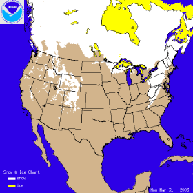
| The image to the right shows the snow cover on March 31st 2003, after a snowstorm left up to 15 inches (38.1 cm) of snow over portions of the Northeast and Mid-Atlantic. Pennsylvania received between 5 - 10 inches (12.7 - 25.4 cm) of snow, while West Virginia and southwestern Virginia received 5 -15 inches (12.7 -38.1 cm). This storm also left up to 6 inches (15.2 cm) across the mountains of the Southeast (eg. Asheville, NC and surrounding area). Click on the image to the right for an animation of snowcover throughout the month of March.
|
 Animated image
 |
 Larger AVI Loop (5.0MB) |
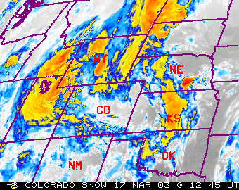
A winter storm brought significant accumulations of snow to parts of Colorado on March 17-19. Snowfall accumulations of 30 to 40 inches (76.2 - 101.6cm) were common across the Denver area. Some of the heaviest snow fell in Gilpin county, just west of Denver, where up to 87.5 inches (222cm) of snow fell. For more information on this event, contact the Denver, CO National Weather Service home page. |
|
 Larger image
 |
The image to the left shows the percent of average seasonal snow fall for stations across the continental U.S. (Data is based on preliminary reports, final values will likely change for some stations). Many of the stations were significantly below average across much the West. Stations in the eastern U.S. received a greater percentage of their seasonal snow fall as of May 1st, with some stations recording over twice the seasonal average. The tracks of several major winter storms are visible (from paths of stations registering above average seasonal totals), such as a swath from northeastern Oklahoma through Missouri and Illinois to Indiana.
|
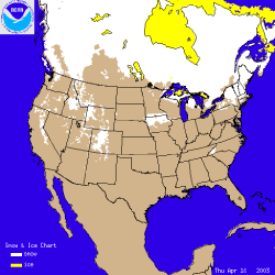
| The image to the right shows the snow cover on April 10th 2003, after a late winter snowstorm left up to 22 inches (55.8 cm) of snow over high elevations of western North Carolina. The storm also quickly dumped 2-8 inches (5-20cm) in and around the lower elevations of Asheville, NC, and was accompanied by lightning and thunder. Elsewhere in the U.S., a large snow storm on April 6th-8th caused problems for residents in the Central Plains as snow depths of 4-8 inches (10-20cm) were common throughout the area. An animated image of daily snow cover over the U.S. through the month of April can be seen by clicking on the image to the right. The general northward retreat of snow cover across the continent during the month is visible in this animation.
|
 Animated image
 |
|
 Animated image
 |
The image to the left shows snow cover on May 1st and by clicking on the image, an animation displays the general northward retreat of snow throughout the month of May 2003. Sea-ice dimished across Hudson Bay and other inland water during the month and despite a few late season snowfalls across the western U.S., snow gradually melted back, leaving only high elevations with some remaining snow cover. |
| The 2002/2003 snow season was generally above average along the eastern seaboard. Stations from Oklahoma northeastward to the Great Lakes also received as much as 200% of normal snowfall for the 2002/2003 season. Stations in the West and upper Midwest were mostly below normal for the season although the Rockies' Front Range and parts of the Sierra Nevada Mountains had near average snowfall. |
|
| For all climate questions other than questions concerning this report, please contact the National Climatic Data Center's Climate Services Division: |
|
Climate Services and Monitoring Division NOAA/National Climatic Data Center 151 Patton Avenue Asheville, NC 28801-5001 fax: +1-828-271-4876 phone: +1-828-271-4800 email: ncdc.info@noaa.gov To request climate data, plese E-mail: ncdc.orders@noaa.gov
   Downloaded Thursday, 25-Sep-2008 15:19:10 EDT Last Updated Tuesday, 23-Sep-2008 13:09:21 EDT by Alvin.L.McGahee@noaa.gov Please see the NCDC Contact Page if you have questions or comments. |
