|
 NCDC /
Clim. Monitoring /
Climate-2003 /
Apr /
U.S. Regional Drought /
Search /
Help

|
Climate of 2003 - April
Wyoming
Drought
National Climatic Data Center, 15 May 2003
|

|
Overview /
Impacts

 Overview Overview
 Impacts Impacts
|
The following state summary was provided by the Wyoming State Climatologist (Jan Curtis):
Statewide Summary
Temperatures for the month of April were above normal across much of Wyoming. Average temperatures ranged from 6 degrees above normal in parts of Crook, Big Horn, and Fremont counties to near normal in parts of Lincoln, Sublette, Carbon, and Hot Springs counties.
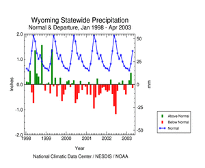
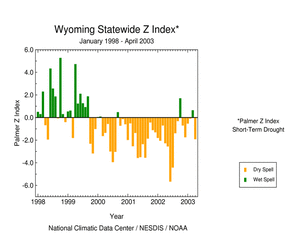
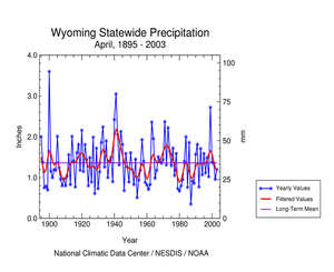
Precipitation for the month of April also showed large variation across the state. The heaviest moisture amounts fell in portions of southeastern, northwestern, and north central Wyoming (>130 percent), the least over southwestern Wyoming counties (<25 percent). The drought that has persisted in Wyoming since the spring of 2000 continues.
Cheyenne
The average temperature in April was 45.8F. This is 4.2F warmer than normal. The maximum for the month was 75 F on the 13th (record for the day) and the minimum of 21F occurred on the 5th. Precipitation total of 2.15 inches is 139 percent of normal. Snowfall totaled 6.2 inches which is 61 percent of the long term
average.
Laramie
The average temperature in April was 40.0F. This is 2.8F warmer than normal. The maximum for the month was 70F on the 13th (records for the day) and the minimum for the month was 16F that occurred on the 8th. Precipitation total of 1.28 inches is 121 percent of normal. Snowfall totaled 13.6 inches which is 189 percent of the long term average. A few cooperative observers in and around Laramie recorded between 2.5 and 3.0 inches of water-equivalent precipitation in April.
Rawlins
The average temperature in April was 43.0F. This is 1.4F warmer than normal. The maximum temperature for the month was 69F on the 12th and 13th and the minimum temperature for the month of 17F occurred on the 5th. Precipitation total of 1.47 inches is 139 percent of normal. Snowfall totaled 12.0 inches which is 169 percent of the long term average.
Rock Springs
The average temperature in April was 43.4F. This is 3.7F warmer than normal. The maximum temperature for the month was 68F on the 10th and 11th and the minimum of 15F occurred on the 4th. Precipitation total of 0.30 inch is 29 percent of normal. Snowfall totaled 3.1 inches which is 50 percent of the long term average.
Evanston
The average temperature in April was 40.1F. This is 1.2F warmer than normal. The maximum temperature for the month was 67F on the 10th and the minimum of 12F occurred on the 4th. Precipitation total of 0.82 inch is 73 percent of normal. Snowfall totaled 7.3 inches which is 140 percent of the long term average.
Big Piney
The average temperature in April was 38.2F. This is 1.8F warmer than normal. The maximum temperature for the month was 66F on the 11th, 12th, and 13th and the minimum of 11F occurred on the 4th. Precipitation total of 0.10 inch is 19 percent of normal. Snowfall totaled 0.8 inch which is 23 percent of the long term average.
Lander
The average temperature in April was 47.7F. This is 3.8F warmer than normal. The maximum temperature for the month was 74F on the 11th and the minimum for the month of 19F occurred on the 4th. Precipitation total of 0.88 inch is 43 percent of normal. Snowfall totaled 0.2 inch which is 1 percent of the long term average.
Riverton
The average temperature in April was 47.7F. This is 3.5F warmer than normal. The maximum temperature for the month was 74F on the 13th and the minimum for the month of 20F occurred on the 7th. Precipitation total of 1.10 inches is 109 percent of normal. Snowfall totaled 1.4 inches which is 25 percent of the long term average.
Worland
The average temperature in April was 49.6F. This is 2.1F warmer than normal. The maximum temperature for the month was 79F on the 12th and the minimum of 20F occurred on the 5th. Precipitation total of 1.49 inches is 182 percent of normal. No snowfall occurred although the long term average is 3.1 inches.
Sheridan
The average temperature in April was 47.2F. This is 3.3F warmer than normal. The maximum temperature for the month was 79F on the 12th and the minimum for the month of 18F occurred on the 5th. Precipitation total of 2.29 inches is 129 percent of normal. Snowfall totaled 1.3 inches which is 12 percent of the long term
average.
Casper
The average temperature in April was 45.6F. This is 2.9F warmer than normal. The maximum temperature for the month was 75F on the 13th and the minimum for the month of 14F occurred on the 5th. Precipitation total of 1.54 inches is 101 percent of normal. Snowfall totaled 6.6 inches which is 52 percent of the long term average.
Torrington
The average temperature in April was 49.3F. This is 3.3F warmer than normal. The maximum temperature for the month was 83F on the 13th (tied for record for the day) and the minimum for the month of 20F occurred on the 8th. Precipitation total of 2.23 inches is 133 percent of normal. Snowfall totaled 8.1 inches which is 245 percent of the long term average and represents the 8th snowiest April on record since 1922.
Additional details, including graphs and tables, are available at:
http://www.wrds.uwyo.edu/wrds/wsc/monthsum/2003Apr/2003Apr_summary.html
|
 NCDC /
Clim. Monitoring /
Climate-2003 /
Apr /
U.S. Regional Drought /
Search /
Help NCDC /
Clim. Monitoring /
Climate-2003 /
Apr /
U.S. Regional Drought /
Search /
Help
http://www.ncdc.noaa.gov/oa/climate/research/2003/apr/st048dv00pcp200304.html
Downloaded Sunday, 12-Oct-2008 09:45:22 EDT
Last Updated Friday, 18-Nov-2005 14:11:42 EST by Richard.Heim@noaa.gov
Please see the NCDC Contact Page if you have questions or comments.
|
|

 NCDC /
Clim. Monitoring /
Climate-2003 /
Apr /
U.S. Regional Drought /
Search /
Help


