World Book at NASA for Students

|
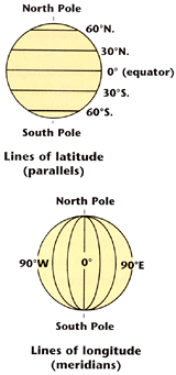
Meridians of longitude run north and south along the surface of the Earth. Mapmakers think of the Earth as a huge globe that is divided into 360 equal slices. Meridians of longitude divide the slices on the outside of the globe.
Parallels of latitude run east and west along the Earth's surface. The equator is a parallel of latitude that circles the middle of the Earth. The latitude of a point is measured by its distance from the equator.
How to cite this article: To cite this article, World Book recommends the following format: "Longitude and latitude." The World Book Student Discovery Encyclopedia. Chicago: World Book, Inc., 2005.
Image to left: Earth can be divided into lines of latitude and lines of longitude. Credit: World Book diagram
| ‹ Previous › Next › Return to Topics | › Back to Top |