

Images & Animations
-
Credit
NASA/Goddard Space Flight Center Scientific Visualization Studio
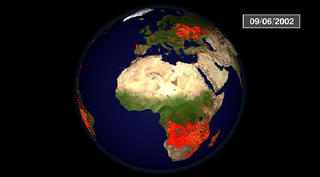
Multisensor Fire Observations without Labels (HD Version)
From space, we can understand fires in ways that are impossible from the ground. New Earth-observing satellites capture the significant impact of fires on our planet. In this animation of fires around the globe in 2002, each red dot marks a new fire. Dots change color to yellow after a few days and to black when fires burn out. From brush fires in Africa to forest fires in North America, satellites are locating every significant fire on Earth to within one kilometer. In the summer and fall burning seasons, particularly destructive fires occurred in Colorado, Arizona, and Oregon. This version of the animation displays a minimal set of labels. For a closed captioned version of this animation, see the standard definition version at animation ID 2806.
The High Definition version of the Multisensor Fire Observation animation with audio and minimal annotations.
Metadata
-
Sensor
Terra/MODIS, TRMM/TMI, TOMS/TOMS, Terra/MISR, Terra/ASTER, Space Shuttle/SRTM, QuikSCAT/SeaWinds -
Animation ID
2854 -
Video ID
none -
Start Timecode
00:00:00:00 -
End Timecode
00:00:00:00 -
Animator
Cindy Starr, Horace Mitchell, Randall Jones, Alex Kekesi, Marte Newcombe, Lori Perkins, Greg Shirah, Eric Sokolowsky, James W. Williams -
Studio
SVS -
Writer
Jarrett Cohen -
Narrator
Michael Starobin (HTSI) -
Visualization Date
2003/11/11 -
Scientist
Chris Justice (University of Maryland), Robert Sohlberg (University of Maryland), William C. North (NASA/GSFC), Fred J. Gunther (CSC) -
Datasets
USGS/GTOPO30, Aerosol Index, Fire Location, Landcover, Population, Wind, Topography -
Keywords
Fire, Biscuit, Hayman, Rodeo, HDTV -
DLESE Subject
Natural hazards, Atmospheric science, Forestry -
Data Date
2001/10/01 - 2002/09/30 -
Animation Type
Regular