Marine Products
The National Weather Service in Marquette provides marine forecast graphics for Lake Superior, including wave height, wind speed, and wind direction. The National Weather Service in Chicago provides marine forecast graphics for Lake Michigan. The forecasts provide a graphical representation of forecast conditions on Lake Superior and Michigan for 48 hours. Feedback is always appreciated.
Click image for graphical forecast of selected area
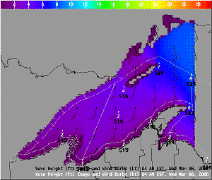 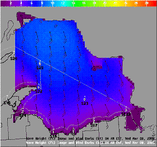
Graphical Forecasts for Lake Superior East Half and West Half....(more detailed)
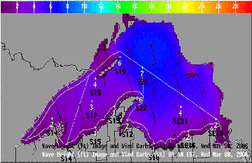 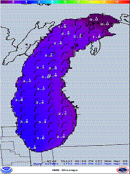
Graphical Forecasts all of Lake Superior Graphical Forecasts for Lake Michigan
NWS Marine Text Products for the Western Great Lakes:
Click here for the National Marine Forecast Page.
Click here for active Special Marine Warnings and Advisories
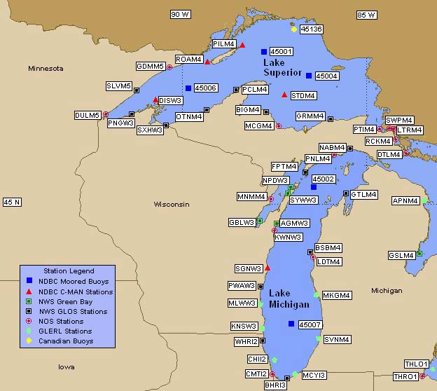
Click on a station for current and past conditions
Marine observations provided and maintained by the National Data Buoy Center
The Nearshore Marine Forecast
NWS Marquette is responsible for issuing a nearshore marine forecast for waters within 5 miles of the south shore of Lake Superior from the Wisconsin/Michigan Border (Saxon Harbor) to Whitefish Point, Michigan, and the north shore of Lake Michigan from Cedar River, Michigan, to Seul Choix Point, Michigan. The nearshore forecast is issued during the same time frame that daylight savings time is in effect.
Nearshore forecasts will normally be basedupon guidance contained in the Lake Superior forecast (issued by NWS Marquette) and Lake Michigan forecast (issued by NWS Chicago). However, this guidance is not considered binding on the local nearshore marine forecast. The nearshore forecast is issued within one hour of the open lake forecast.
Content of the Nearshore Forecast
1. Gale or storm warnings or small craft advisories applicable to the nearshore area. (See below for the definition of a gale or storm warning.)
2. Expected wind direction and speed (rounded off to the nearest 5 knots).
3. Expected cloud cover, precipitation, thunderstorm or squall line activity and obstructions to visibility (3 miles or less).
4. Expected waves.
If a gale or storm warning is in effect for the open lake and not for nearshore waters, this will be mentioned in the text of the nearshore forecast following the winds. (e.g. "GALE WARNING IN EFFECT FOR THE OPEN LAKE").
Warnings and Advisories
Gale Warnings are issued for forecast winds of 34 to 47 knots, inclusive.
Storm Warnings are issued for forecast winds of 48 knots or more.
Small Craft Advisories are issued when sustained winds are forecast to be 18 to 33 knots and/or average waves of 4 feet or higher.
When waves are expected to reach or exceed three feet, people on or near piers, breakwaters, and beaches are advised to avoid these areas or exercise extreme caution until waves subside.
Special marine warnings
Special marine warnings are issued for short terms (usually 2 hours or less) when strong winds (34 knots ormore) are expected to occur. These winds are usually associated with squall lines or strong thunderstorms. A special marine warning maybe issued even though a small craft advisory is in effect. NWS Marquette's area of responsibility for special marine warnings include both the nearshore and open lake zones. (See the Severe Weather Page for active warnings.)
|