Local Drought Information
Last update on Wednesday, September 3, 2008.
Updated during the first week of each month, or more frequently if conditions warrant.
Summary: VERY WET AUGUST RESULTS IN SIGNIFICANT DROUGHT IMPROVEMENTS
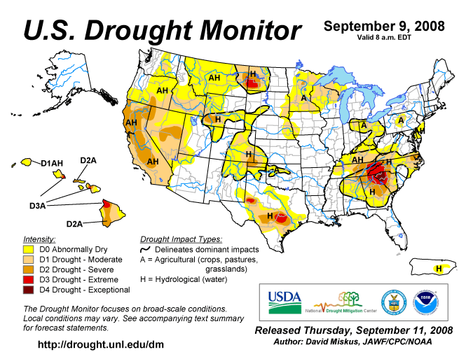
In the August 26th release of the U.S. Drought Monitor, moderate drought conditions were occurring west of Highway 25 and south of Highway 40. No drought conditions were indicated elsewhere in the Tri State area.


The U.S. Drought Monitor is a weekly collaborative effort between a number of federal agencies including NOAA/NWS, U.S. Department of Agriculture and the National Drought Mitigation Center.
| Abnormally Dry (D0) - Going into drought: short-term dryness slowing planting, growth of crops or pastures; fire risk above average. Coming out of drought: some lingering water deficits; pastures or crops not fully recovered. |
Moderate Drought (D1) - Some damage to crops, pastures: fire risk high; streams, reservoirs, or wells low, some water shortages developing or imminent, voluntary water use restrictions requested. |
| Severe Drought (D2) - Crop or pasture losses likely; fire risk very high; water shortages common: water restrictions imposed. |
Extreme Drought (D3) - Major crop/pasture losses: extreme fire danger; widespread water shortages or restrictions. |
| Exceptional Drought (D4) - Exceptional and widespread crop/pasture losses; exceptional fire-risk; shortages of water in reservoirs, streams, and wells, creating water emergencies. |
State and Local Actions
No known actions at this time.
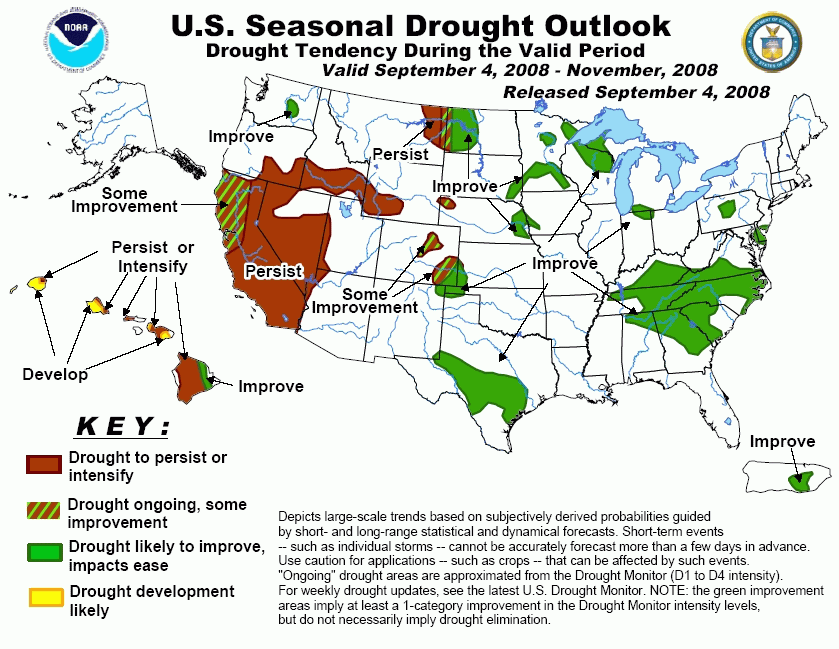
Seasonal Drought Outlook
VALID THROUGH NOVEMBER 2008...any lingering drought areas are forecast to improve.

The image above is compliments of NOAA
Climatological Summary
AUGUST 2008
AUGUST WAS VERY WET IN AREAS WEST OF HIGHWAY 25. MANY LOCATIONS
RECEIVED MORE THAN 6 INCHES FOR THE MONTH...WHICH WAS ENOUGH TO RANK
IT AS ONE OF THE WETTEST AUGUSTS ON RECORD. THESE WERE ALSO THE AREAS
WHICH HAD BEEN IN MODERATE TO SEVERE DROUGHT THROUGH THE SPRING AND
EARLY SUMMER MONTHS. AS A RESULT...THE DROUGHT MONITOR SHOWED
SIGNIFICANT IMPROVEMENTS...WITH SOME AREAS IMPROVING BY 2 CATEGORIES
IN JUST ONE MONTH. RAINFALL AMOUNTS DROPPED QUICKLY EAST OF HIGHWAY
25...WITH LESS THAN 3 INCHES FALLING ALONG A CORRIDOR FROM HITCHCOCK
COUNTY NEBRASKA SOUTH TO GOVE COUNTY KANSAS. IN FACT...SOME OF THESE
AREAS MAY BE SLIPPING INTO SHORT TERM DROUGHT WITH NEARLY HALF OF
NORMAL REPORTED IN GOVE COUNTY THE PAST THREE MONTHS...THOUGH THIS
IS NOT YET REFLECTED IN THE OFFICIAL DROUGHT MONITOR. THE FAR
EASTERN PARTS OF THE AREA...FROM MCCOOK TO HILL CITY...RECEIVED
PLENTIFUL RAINFALL IN AUGUST AND CONTINUED TO SHOW NO SIGNS OF
DROUGHT.
AUGUST 2008 RADAR ESTIMATED PRECIPITATION

More precipitation maps are available on the AHPS home page.
Agricultural Impacts
Reported at the end of AugustTop Soil
| Region |
Very Short |
Short |
Adequate |
Surplus |
| Northwest KS |
7 |
22 |
56 |
15 |
| West Central KS |
26 |
41 |
33 |
0 |
| Nebraska |
10 |
38 |
51 |
1 |
| Eastern CO |
3 |
33 |
63 |
1 |
Sub Soil
| Region |
Very Short |
Short |
Adequate |
Surplus |
| Northwest KS |
14 |
33 |
49 |
4 |
| West Central KS |
22 |
37 |
41 |
0 |
| Nebraska |
9 |
34 |
56 |
1 |
| Eastern CO |
13 |
49 |
38 |
0 |
Information provided by USDA National Agricultural Statistics Service (NASS).
Soil moisture supply measures how much moisture is present in cropland top soil during the week. Soil moisture is reported as a percentage.
| Very Short - Soil moisture supplies are significantly less than what is required for normal plant development. Growth has been stopped or nearly so and plants are showing visible signs of moisture stress. Under these conditions, plants will quickly suffer irreparable damage. |
Short - Soil dry. Seed germination and/or normal crop growth and development would be curtailed. |
| Adequate - Soil moist. Seed germination and/or crop growth and development would be normal or unhindered. |
Surplus - Soil wet. Fields may be muddy and will generally be unable to absorb additional moisture. Young developing crops may be yellowing from excess moisture. |
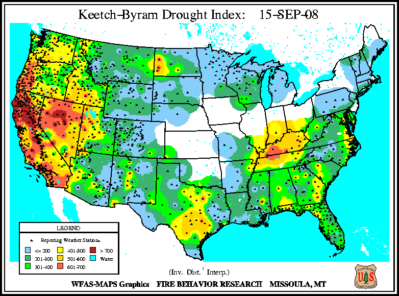
Fire Danger Hazards
The image above is the Keetch-Byram Drought Index and is designed specifically for fire potential assessment. It is a continuous index, relating to the flammability of organic material in the ground.
0 to 200. Low- Wet with little danger of fire initiation.
201 to 400. Moderate- Drying occurring with some fire danger.
401 to 600. High- Ground cover dry and will burn readily.
601 to 800. Extreme- Dead and live fuels will burn readily.
|