 |
 |
 |


Researchers Map America's Deadliest Roads
Online satellite imagery also provides crash data in public policy effort to boost safety|
|
HealthDay
By Kevin McKeever
Monday, July 28, 2008
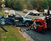 MONDAY, July 28 (HealthDay News) -- You can now find the deadliest road in your town or your route to work through an online interactive map program that aims to increase public awareness of the need to drive safely.
Researchers at the University of Minnesota's Center for Excellence in Rural Safety (CERS) developed www.saferoadmaps.org, so you can simply enter your address to see a map or satellite image of all of the road fatalities that have occurred in the area. Users can narrow their search to see the age of the driver, whether speeding or drinking was a factor, and if the driver was wearing a seat belt.
"When drivers type in their most common routes, they're shocked how much blood is being shed on it," CERS Research Director Tom Horan said in a news release issued by the university. "When it's the route you or your loved ones use, the need to buckle up, slow down and avoid distractions and drinking suddenly becomes much more personal and urgent."
The researchers were scheduled to unveil the Web site Monday in Santa Rosa, Calif., as part of their annual conference on rural safety.
CERS officials hope the site will help make a difference on the road and educate drivers as well.
One big target audience is rural drivers, because, according to the Federal Highway Administration, 57 percent of highway deaths happen on rural roads.
"By mapping out these fatalities, we can visually see what a large problem we have in our country," Lee Munnich, director of CERS in the university's Humphrey Institute for Public Affairs, said in the same news release. "It is time to start working toward prevention, and each one of these dots on the map represents that."
HealthDay
Copyright (c) 2008 ScoutNews, LLC. All rights reserved.
Related News:
More News on this Date
Related MedlinePlus Pages:
| Home | Health Topics | Drugs & Supplements | Encyclopedia | Dictionary | News | Directories | Other Resources | |
| Disclaimers | Copyright | Privacy | Accessibility | Quality Guidelines U.S. National Library of Medicine, 8600 Rockville Pike, Bethesda, MD 20894 National Institutes of Health | Department of Health & Human Services |
Date last updated: 29 July 2008 |