Source Water Assessments
ALL ABOUT PDF FILES|
States conduct source water assessments and produce studies or reports that provide basic information about the drinking water in each public water system. The source water assessment programs created by states differ, because each program is tailored to a state's water resources and drinking water priorities. This page summarizes the major steps in creating a source water assessment, explains how the public can access assessment summaries, tells how communities can use state assessments to help protect source water, and provides a link to answers to some questions frequently asked about source water assessment.
Source Water Assessment StepsA list of publications relevant to assessments is available. For a complete list of publications and resources, search the bibliography. Step 1: Delineate the source water assessment area
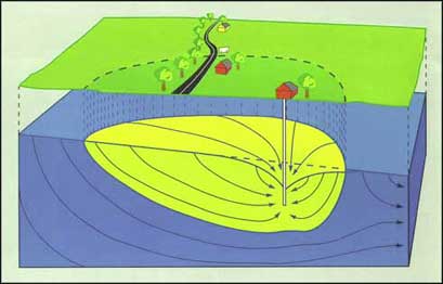
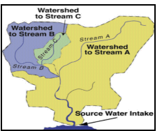
For each ground water well or surface water intake that supplies public drinking water, the state must delineate or map the land area that could contribute water and pollutants to the water supply. Significant potential sources of contamination are identified in this delineated area during Step 2 of the assessment process. For ground water supplies, states commonly use information about the flow of underground water to delineate source water assessment boundaries. This approach results in a map that shows land areas where, if pollutants were spilled or discharged on the surface, they could filter through the soil to the ground water and be drawn into a particular well. Some states use a simpler mapping approach, drawing a circle of a certain radius around each well. For a community that uses surface water from a stream, river, lake, or reservoir, the land area in the watershed upstream of the intake is identified on the map. A watershed boundary is drawn by using a topographic map, and the boundary includes the land areas where rain or melted snow flows over or through the ground and eventually enters the water source upstream of the water system's intake. Some states divide the watershed area into segments -- in the areas closest to the intake, where most types of contamination sources can affect the water supply, and the other, more distant areas. The entire watershed up to the state's boundaries must be delineated, but the inventory of potential pollution sources might be more detailed in the segments closer to the intake.
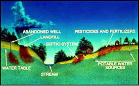
After the state has completed its assessment for a water system, the community may decide to undertake protection efforts for targeted sources of contamination. An initial step could be to expand on the state's delineation process. Particularly for small ground water systems, where states might not have the resources to conduct a detailed delineation, additional scientific methods can be used to more accurately delineate the area that contributes ground water to the well. Community members can seek assistance from the environmental sciences, geology, or engineering departments of local colleges or from environmental consulting firms in creating more detailed delineations. Sometimes professors, graduate students, or local firms provide these services for a reduced fee or none at all. In addition, local water resource information is often available from other sources such as the federal Natural Resources Conservation Service, the U.S. Geological Survey, and the state's Cooperative Extension Service. Delineation tools - Provides links to tools and databases that might help in mapping areas that are the source of a drinking water supply. Step 2: Conduct an inventory of potential sources of contamination Community groups and public water systems are often especially involved in the second step of an assessment -- identifying potential sources of pollutants that could contaminate the water supply. This inventory usually results in a list and a map of facilities and activities within the delineated area that might release contaminants into the ground water supply (for wells) or into the watershed of the river or lake (for surface water sources). Some examples of potential pollutant sources are landfills, underground or aboveground fuel storage tanks, residential or commercial septic systems, stormwater runoff from streets and lawns, farms that apply pesticides and fertilizers, and sludge disposal sites.
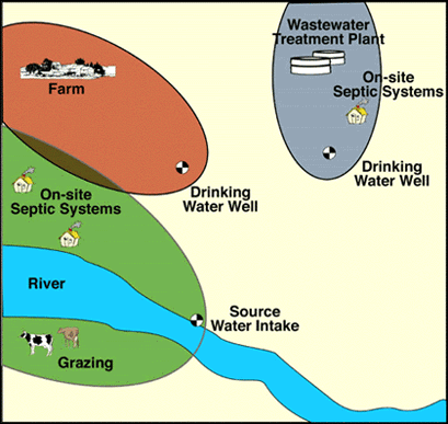
Some states ask communities or public water systems to review the inventory to obtain detailed information about potential contaminant sources. Others use computer databases and focus the inventory on land uses and activities that are currently mapped or regulated. Although the latter approach might not address sources of contaminants that are not currently regulated, such as small livestock areas or auto salvage yards, the database inventories could include industries and sewage treatment plants that discharge wastewater, hazardous waste sites, mining operations, particular land use categories (such as industrial, agricultural and urban areas), and various facilities that have environmental permits. Community groups such as watershed organizations, local environmental committees or scout troops can enhance the state's assessment by conducting site-specific inventories of potential pollutant sources that might not be on state databases or maps. Local inventories might provide information on abandoned dump sites, businesses with septic tanks or floor drains (such as dry cleaners or car repair shops), pesticide mixing and storage areas, golf courses, and other land uses that might release pollutants to ground water or surface water. Community groups can coordinate their local inventory with the state's assessment process or can enhance a completed assessment with a more detailed inventory. State Source Water Assessment and Protection Guidance (PDF 160 pp, 486 K)
Step 3: Determine the susceptibility of the water supply to contamination For the susceptibility analysis, the state combines the inventory results with other relevant information to decide how likely a water supply is to be contaminated by identified potential sources of contamination. This critical step makes the assessments useful for communities because it provides information that local decision makers can use to prioritize their approaches for protecting the drinking water supply. Local information provided to the state by local community groups about contaminant sources, water resource characteristics or environmental management practices may be used in the susceptibility determination process. Some states prioritize the potential for contamination from identified potential contamination sources or specific chemicals that could pollute the water. Other states assign susceptibility rankings of high, medium, or low to the water sources.
Susceptibility determination tools - Provides links to tools and databases that might be of use in determining the susceptibility of a source of drinking water to contamination. These links include risk assessment and health effects information. [Top of Page]Public Availability and Consumer Confidence ReportsAfter a state completes the assessment of a particular water system, it summarizes the information for the public. Such summaries help communities to understand the potential threats to their water supplies and to identify priority needs for protecting the water from contamination. States make the assessment summaries available to the public in a variety of ways. Some states convene public workshops, while others make copies available in public libraries and from local government offices or water suppliers. Many have posted their assessment information on the Internet.
Consumer confidence reports (CCRs) include information about the availability of the assessment and a brief summary describing the susceptibility of the system to contamination. EPA's guidance on including source water information in consumer confidence reports (CCRs), published as part of its State Implementation Guidance on CCRs, includes
Consumer Confidence Reports (CCRs) - These reports tell where drinking water comes from, what's in it, and how you can help protect it. [Top of Page]Using the Assessment for ProtectionWhether using the state's assessment or expanding it into a more detailed local assessment, communities can use information gathered through the assessment process to broaden their source water protection programs. Community groups and local officials, working in cooperation with local, regional and state government agencies can plan how to manage identified potential contamination sources and prevent new contaminant threats in the source water assessment area. Communities use a wide array of different source water protection methods to prevent contamination of their drinking water supplies. One management option involves regulations, such as prohibiting or restricting land uses that might release contaminants in critical source water areas. Along with approving regulations, many communities hold local events and distribute information to educate citizens and businesses and encourage them to recycle used oil, limit their use of pesticides, participate in watershed cleanup activities and a multitude of other protection activities. Another potential aspect of a source water protection program is the purchase of land or creation of conservation easements to serve as a protection zone near the drinking water source. For an effective protection program, communities should consider using a variety of prevention measures. EPA's fact sheet Community Involvement in Source Water Assessments (PDF 5 pp, 176 K) explains the three steps of source water assessments, how communities can participate in the assessment process, and how communities can use assessment information to help protect source water. Other resources include
Protection tools - Provides links to information resources or programs that may be of use when implementing protection measures for drinking water sources. [Top of Page]Frequent Questions About AssessmentsFrequent questions about source water assessments provides detailed questions and answers about the source water assessment program. |