|
CNRFC River Guidance Products
River Forecast Guidance products are issued jointly with the California Department of Water Resources. These products
are for guidance purposes only. Select WFO Products for OFFICIAL public issuances of hydrologic
watches, warnings, statements, and advisories.
Graphical River Forecast Products - Observed/Forecast Hydrographs
The graphical river forecast products display observed and forecast hydrograph data. Included is a graphic display of the hydrologic input "Rain + Melt" that was used as input to the hydrologic model (averaged
for all upstream basins.)
[ Learn more about this product ]
Please Note: To ensure that you are viewing the latest hydrograph images, it is recommended that you use your browser's refresh or reload button often to avoid viewing previously cached images. Another recommended option is to set your browser to always check for newer versions of stored pages every visit. See your browser help section for more information related to temporary internet file and/or cache settings.
| Map Type: |
  | Current Zoom Factor: |  | Help: |  | |
 |
|

|
River Guidance
Forecast Status
(Approx 5 Days)
Graphical RVF Search
Gage Information
Place cursor over gage
on map for readout.
|
|
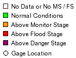
90 Gages Forecast
Normal Conditions
(100.0% of Gages) | 0 Gages Forecast
Above Monitor Stage
(0.0% of Gages) | 0 Gages Forecast
Above Flood Stage
(0.0% of Gages) | 0 Gages Forecast
Above Danger Stage
(0.0% of Gages) | |
Last Map Update: Tuesday August 25th 2009 at 7:40 AM PDT (3 Minutes Old)
(Data is updated every 10 minutes)
|
|
| River Guidance Points Forecast Above Specified Stage Definitions (Select NWSLI for Station Plot) | | NWSLI | River / Creek | Gage / Station | Monitor
Stage | Flood
Stage | Danger
Stage | Max 4Cast
Stage | Max 4Cast
Flow | Forecast
Status |
NO River Guidance Points Currently Forecast Above Specified Stage Definitions. |
** NOTE ** Stage is presented in "Feet" while Flow is presented in "cfs". |
Alternate Text Menu for Graphical River Products
| River Guidance - Flood Forecast Points |
| North Coast and Upper Klamath |
Upper Sacramento |
|
|
| Navarro-Russian-Napa |
Lower Sacramento |
|
|
| Central California Coast |
San Joaquin |
|
|
| Southern California |
East Side Sierra - Humboldt River |
|
|
| River Guidance - Other Points |
| North Coast and Upper Klamath |
Upper Sacramento |
|
|
| Navarro-Russian-Napa |
Lower Sacramento |
|
|
| Central California Coast |
San Joaquin |
|
|
| Southern California |
East Side Sierra - Humboldt River |
|
|
PLEASE NOTE: On October 1, 2006, the California Department of Water Resources(DWR) changed the reporting of all tide data collected at 44 locations in the Sacramento-San Joaquin Delta and Suisun Marsh from National Geodetic Vertical Datum 1929 (NGVD29) to the North American Vertical Datum 1988 (NAVD88) standard. Tide stage forecasts for four delta locations (Rio Vista, Antioch, Mallard Island and Venice Island) and river stage forecasts for three river forecast points (Mokelumne River at Bensons Ferry near Thornton, San Joaquin River at Mossdale Bridge, and Yolo Bypass at Lisbon) are now displayed as NAVD88. The change to NAVD88 also affects the monitor stage and flood stage at four locations. More information can be found on our October 2006 Datum Change Information webpage.
Daily River Forecast Guidance (Text Format)
Event-driven River Forecast Guidance (Text Format)
Tide Tables (pdf format - requires Adobe® Acrobat Reader)
2008 - Golden Gate Bridge, Rio Vista, Port of Sacramento, I Street
2008 - Golden Gate Bridge, Antioch, Venice Island, Port of Stockton
2009 tides - Golden Gate Bridge, Rio Vista, Port of Sacramento, I Street
2009 tides - Golden Gate Bridge, Antioch, Venice Island, Port of Stockton
Historical Graphical River Forecasts
Verification graphics of the CNRFC River Guidance "Flood Forecast Points" are available. To create your graphic, either:
|