

Images & Animations
-
Credit
NASA/Goddard Space Flight Center Scientific Visualization Studio
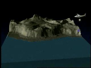
Greenland: Top-down view of Island tour with airplane tracks
Top-down view of Greenland Island tour.This animation shows the ice concentration in Greenland. The ice has decreased significantly (~50 cm/year) along the coast and increased slightly in the center (+2 cm/year). Researchers view this as yet another serious warning sign of the threat of global warming.
Animation to show how a plane takes coastal measurements
Metadata
-
Sensor
ATM/ATM -
Animation ID
1253 -
Video ID
SVS2000-0018 -
Start Timecode
1:00:35:00 -
End Timecode
1:02:20:00 -
Animator
Lori Perkins -
Studio
SVS -
Visualization Date
2000/06/25 -
Scientist
Dorothy Hall (NASA/GSFC) -
Citation
Krabill, W., Abdalati, W., Frederick, E., Manizade, S., Martin, C., Sonntag, J.,Swift, R., Thomas, R., Wright, W. and Yungel, J. 2000. Greenland ice sheet: High-elevation balance and peripheral thinning. Science 289: 428-430 -
Datasets
Topography -
Keywords
Ice, GCMD--Location--Greenland, Laser Altimeter, glacier, coastal measurement -
DLESE Subject
Technology, Climatology, Cryology -
Data Date
1993/06-1993/07, 1994/05-1994/06, 1998/06-1998/07,1999/05, 1999/06-1999/07 -
Story URL
stories/greenland/index.html -
Animation Type
Regular