| ......MARINE WEATHER |
| |
| National Marine Forecasts Page |
| |
| ......COASTAL MARINE FORECASTS |
| Point Forecast Matrix Interface |
| Washington |
| Oregon Northern | Southern |
| California Northern | Central | Southern | Mexican Border | Offshore 60 to 250 nm |
| High Seas Forecast - Eastern Pacific |
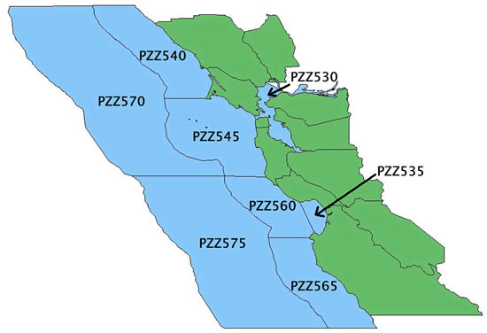
New Marine Zones Effective Tuesday October 2 2007
Effective Tuesday October 2 2007 at 0900 Pacific Daylight Time (PDT) the Marine Forecasts from WFO Monterey will be reconfigured to account for differences in weather and climatology for the Central California Coast. This will affect the inner water zones (0-20 nautical miles) from Point Arena to Point Piedras Blancas. This change involves the following two improvements:
- Marine Zone (PZZ550) currently extends from Point Arena to Pigeon Point out to 20 nautical miles. This Marine Zone will be split into two zones…Point Arena to Point Reyes out to 20 nautical miles (PZZ540) and Point Reyes to Pigeon Point out to 20 nautical miles (PZZ545).
- Marine Zone (PZZ555) currently extends from Pigeon Point to Point Piedras Blancas out to 20 nautical miles. This Marine Zone will be split into two zones…Pigeon Point to Point Pinos out to 20 nautical miles (PZZ560) and Point Pinos to Point Piedras Blancas out to 20 nautical miles (PZZ565).
|
|
San Francisco and Monterey Bay waters
|
| |
| ......MAPS & GRAPHICS |
|
Morning Briefing for the Pacific - This briefing page is made by the Ocean Prediction Center and is meant for printing out the marine weather charts displayed so if you have a slow connection it will take some time to download. Using the print command you should be able to print all of the charts on separate 8.5 inches X 11 inch pages. The Pacific Briefing Package will have the 12Z 500 mb, 12Z surface analysis, 12Z or 15Z offshore & adjacent waters sea state analysis, 00Z 24 hour surface, 00Z 24 hour wind/wave, 00Z 48 hour 500 mb, 00Z 48 hour surface, 00Z 48 hour wind/wave, 12Z 96 hour 500 mb, 12Z 96 hour surface, and 12Z 96 hour wind/wave charts. |
|
|
| |
| ......WAVE, SEA STATE, AND SATELLITE DATA |
|
| |
| ......PACIFIC WAVE HEIGHT FORECASTS |
|
| |
| ......SEA SURFACE TEMPERATURE ANALYSIS |
SST charts
|
|
| ......LINKS TO OTHER MARINE SITES |
|
National Marine Sanctuaries
|