|
 |

|
WHAT'S HOT |
|
| | |
|
Giovanni Air Quality Instance now available
 A new Giovanni instance dedicated to air quality related data is now available. The instance includes global aerosol and cloud data from MODIS, global aerosol data from OMI, and the AIRNow Fine Particulate Matter (PM2.5) ground-based monitoring product for the continental United States. A new Giovanni instance dedicated to air quality related data is now available. The instance includes global aerosol and cloud data from MODIS, global aerosol data from OMI, and the AIRNow Fine Particulate Matter (PM2.5) ground-based monitoring product for the continental United States.
+ Read More |
|
|
|
NASA GES DISC Imagery in Google Earth
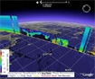 The GES DISC Google Earth portal displays GES DISC data in Google Earth to facilitate scientific research. The data includes 2D flat data such as TRMM, AIRS/Aqua, and 3D vertical data such as CloudSat, CALIPSO, AIRS/Aqua and MODIS/Aqua. The GES DISC Google Earth portal displays GES DISC data in Google Earth to facilitate scientific research. The data includes 2D flat data such as TRMM, AIRS/Aqua, and 3D vertical data such as CloudSat, CALIPSO, AIRS/Aqua and MODIS/Aqua.
+ Read More |
|
|
|
Hydrology DISC supports GLDAS data product
 The new Hydrology DISC (HDISC) portal provides access and support for the Global Land Data Assimilation Systems (GLDAS). The new Hydrology DISC (HDISC) portal provides access and support for the Global Land Data Assimilation Systems (GLDAS).
+ Read More |
|
|
|
|
EARTH MEASUREMENTS
CURRENT MISSIONS
|
|
LATEST NEWS |
|
| | |
| |
09.09.08 - Ike Moves Over Cuba, Heads to the Gulf
As of 2:00 pm EST September 9th, Hurricane Ike has a forward speed to 12 mph heading in the West/Northwest direction with a wind speed of 75 mph and is located at approximately 22.7N, 83.4W with a central pressure of 970 mb. Hurricane Ike headed to Cuba as a category 3 storm initially and has w...
   
+ Read More | |
| 09.04.08 - HIRDLS Version 004 Atmospheric Products Now Released (Aug 4, 2008)
The version 4 of level 2 HIRDLS Product 'HIRDLS2 version 2.04.19)' is now available. At this time, Temperature, O3, HNO3, CFC-11, CFC-12, Cloudtop Pressure and Aerosol Extinction are available. For more information please see the link below.
+ Read More | |
| 09.03.08 - Precipitation Animation of Hurricane Gustav and The Tropical Atlantic Region
Animations were created using the TRMM 3B42RT data of the Accumulated Rainfall parameter using the GES DISC TRMM Online Visualization and Analysis System (TOVAS)(http://disc2.nascom.nasa.gov/Giovanni/tovas/), which contains TRMM rainfall products, near-real-time 3-hourly, Multi-Satellite Precip...
 
+ Read More | |
| 09.02.08 - High Point Of The Season Proves To Be Active!
As Gustav becomes a tropical depression all eyes turn now to an extremely busy Atlantic region. As high time has come upon us for the hurricane season, storms develop across the Atlantic region just north of the ITCZ (Intertropical Convergence Zone). As of 11:00 am EST we have 3 named storms st...
  
+ Read More | |
| 09.02.08 - MergedIR Animation Shows the Atlantic Storms Movement
An animation created using the Merged IR data which is a Globally-merged (60N-60S) pixel-resolution IR brightness temperature data (equivalent blackbody temps), merged from all available geostationary satellites (GOES-8/10, METEOSAT-7/5 & GMS). The data is available by ftp from the GES DISC (ht...
  
+ Read More | |
|
|
|
+ GES DISC News Archive

|
|


