The most productive coastal hydrographic survey platform in the world!

The most productive coastal hydrographic survey platform in the world!
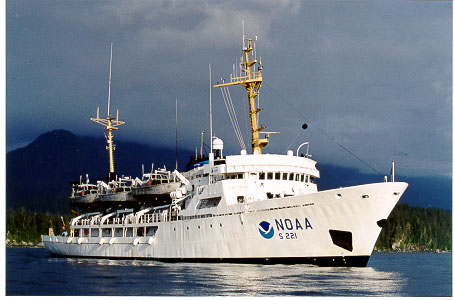
The NOAA Ship RAINIER is designed and outfitted primarily for conducting hydrographic surveys in support of nautical charting. Scientific equipment normally aboard is limited to equipment that supports these survey operations. The ship operates off the U.S. Pacific Coast, and in Alaskan coastal waters. The RAINIER is named for Mount Rainier. The vessel is operated by NOAA's Office of Marine and Aviation Operations..
The RAINIER is a highly capable platform for conducting coastal hydrographic survey operations. She has a crew of fifty-five, including ten commissioned officers. The ship is equipped with an intermediate depth multibeam swath survey system. She carries six aluminum survey launches equipped with multibeam swath and single beam echo sounders and a hydrographic data acquisition system. She also has three small boats providing support to shore stations and dive operations. Seven crew members are trained as certified NOAA divers.
The RAINIER carries other equipment to support hydrographic survey operations. This includes five CTDs used for sound velocity profiles, one side-scan sonar unit for item investigations, and various sediment sampling equipment.
| General Information | Operations | Ship Specifications |
|---|---|---|
|
All Ship Specifications
|
RAINIERS's E-mail address is:
NOAA.Ship.Rainier@noaa.gov
RAINIERS's Mail address is:
NOAA Ship RAINIER
Marine Operations Center, Pacific
1801 Fairview Ave E
Seattle, WA 98102-3767
RAINIERS's Telephone Numbers
• Return to Marine Operations Home Page
• Inquires and Comments
• URL: http://www.moc.noaa.gov/ra/index.html
• Updated March 26, 2007