| Going to the beach? Want to know the water temperature? It's never been easier to find out what the water temperature is on your favorite beach. From the Pacific coast to Atlantic coast, visit the Coastal Water Temperature Guide online and select a region to get up-to-date information on your specific beach. Details.... |
 Daily Rip Current Forecast May 23-Sept 28 Daily Rip Current Forecast May 23-Sept 28
RIP CURRENTS...A
THREAT TO LIFE
Going to the beach? Want to know the water temperature? It's
never been easier to find out what the water temperature is on your favorite
beach. From the Pacific coast to Atlantic coast, visit the Coastal Water Temperature
Guide online and select a region to get up-to-date information on your specific
beach. Details...
RIP CURRENT SAFETY
What is a Rip Current?
Fig 1 Fig 2
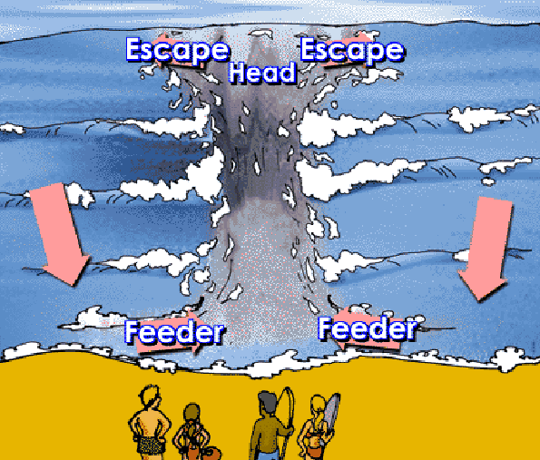 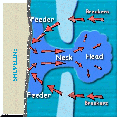
A rip current is strong narrow channel of water
that flows from the surf-zone out to sea. It develops when breaking waves
push onshore, then gravity pulls the water back out to sea. If the water
converges into a narrow river like channel moving away from shore, a Rip
Current forms.
Rip Currents are sometimes mistakenly called an undertow.
However, a rip current will not pull you under the water surface. Rip currents
can be 50 feet to 50 yards in width, and the strength of the current can
be up to 3 to 5 mph, which can carry even a strong swimmer into deeper
water beyond the sandbar. The development and persistence of a Rip Current
requires a mass transport of water from WIND...WAVES and/or SWELL.
The swell or waves produce a greater than normal mass transport of water
onto the beach, causing an above normal volume of receding water, and the
channel or Rip Current is formed.
Safety Precautions and Development Indicators of Rips
The threat to life from rip currents, has led to the establishment
of the Mid Atlantic Rip Current program called MALURCS. MALURCS
is Mid Atlantic Lushine Rip Current Scale, named after Jim Lushine, who
began a rip current program for the southeast Florida coast several years
ago.
Several Rip Current drownings occur each year along the
Mid Atlantic coast. Preliminary Statistics as of July 2001 indicate that
eight rip related drownings have occurred from North Carolina to Massachusetts.
Several Rip-deaths also occurred in the northern Gulf of Mexico due to
Tropical Storm Allison.
The Beach Patrol, lifeguards and EMS, (Emergency Medical
Services) make thousands of rescues each year, saving many lives. Still
Rip Current drownings each year exceed the number of lightning deaths in
this U.S., and is now the number 3 weather related killer behind Heat Stress
and Flooding. In an effort to assist with daily safety beach operation,
the National Weather Service office in Wakefield, along with other offices
along the East Coast, have embarked upon a new program to forecast Rip
Currents based upon favorable meteorological patterns and conditions. A
part of this program involves the local coastal NWS offices alerting the
media and warning the public of this potential threat to life.
How is a Rip Forecast Created?
Each day the marine forecaster will assess the
threat based on meteorological conditions such as wind speed and direction,
the magnitude, period and direction of waves and swell. Once the threat
is assessed, the forecaster will issue a statement describing the threat
level for that day. The following are the three types of threats that our
office will issue.
THREAT
MEANING
HIGH |
weather and ocean conditions
are favorable for the formation of numerous Rip Currents. Several of the
Rip Currents have the potential to be strong, with a 3 to 5 mph seaward
pull. |
MODERATE |
weather and ocean conditions are favorable for a greater
than normal potential for rip current formation. Usually several rip currents
will form and a few may be strong. |
LOW |
weather and ocean conditions for rip formation are
weak. However, few rip currents could form, especially near inlets, jetties,
piers and sandbars. |
When a statement is issued, safety
rules are included that may help a potential victim
survive the affects of a rip current.
If you are a beach goer, what safety precautions should
you take for Rip Currents?
- First and foremost, always swim
at beaches guarded by Beach Patrol or lifeguards.
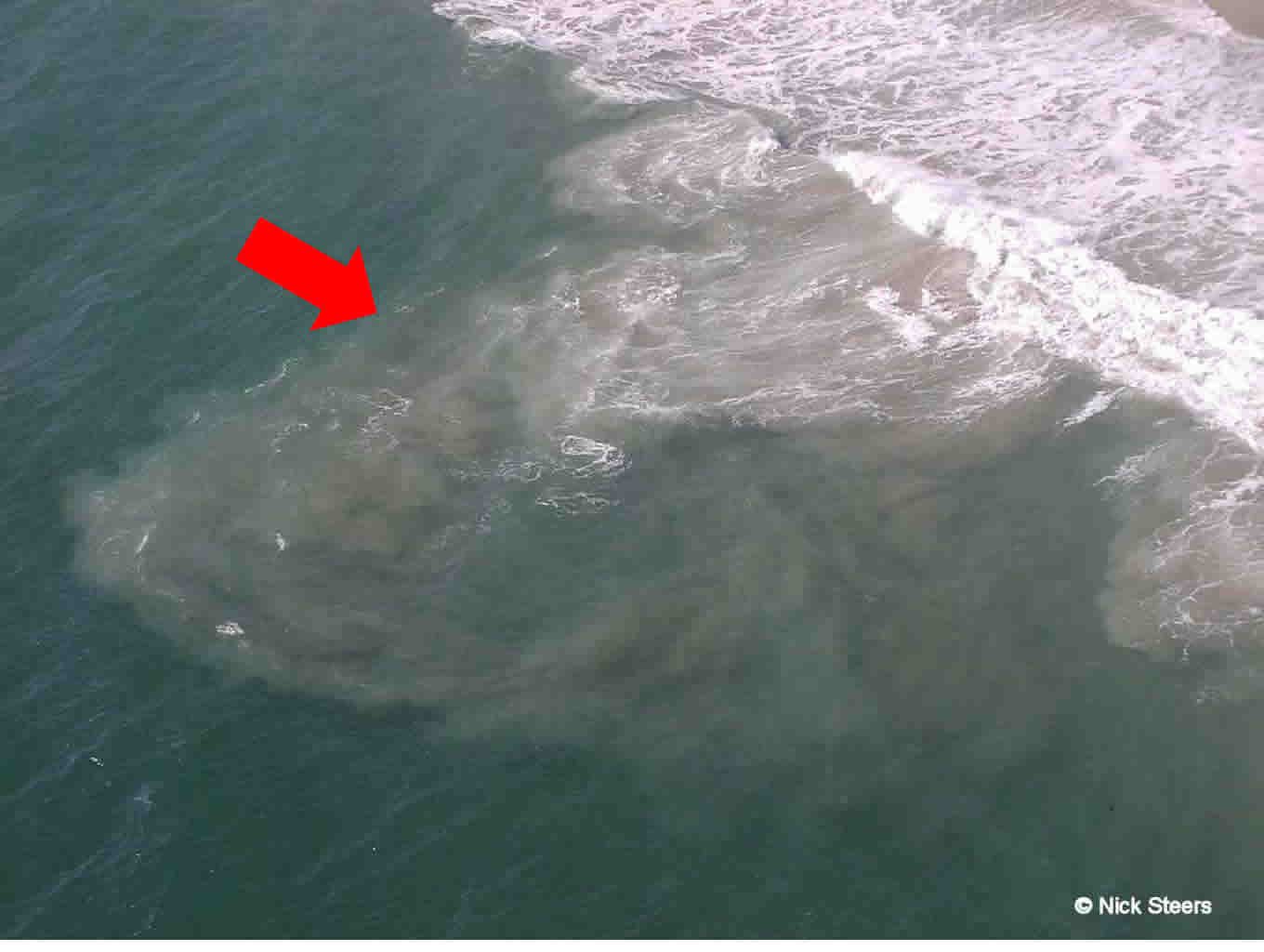
- Know the visible signs of rip currents:
Water traveling from the
beach back out sea. It will likely be turbulent due to the carving
out of a channel in the sub-sea surface sand
At the time of formation though the rip will still have
visible surface waves. (See Figure 2) Once a channel is carved
out, the flow will become more tranquil and even may look calm in comparison
to the surrounding ocean water. At this time the Rip has fully developed
as a subsurface current and is counter-balancing the incoming waves. Thus
the waves are being damped out before coming onshore. This area of calm
is what makes the Rip especially dangerous to the average beach goer. Many
weaker swimmers will propagate toward this calm, non-wave area because
they feel safer. They may even venture out farther in the ocean because
of this false sense of security. More often than not, they realize too
late that they are caught in a Rip current and are being transversed into
deep water and will need assistance to return to shore.
What To Do if Caught in a Rip Current
What should you do if you are caught in a rip current?
First, REMAIN CALM! Signal to someone on the beach, a lifeguard or a friend,
that you need help. If you are a strong swimmer, try to swim parallel to
the beach until you are out of the rip current. Then swim toward the shore.
Never try to swim back to shore directly against the Rip current, as this
can exhaust and drown even the strongest swimmer. For the less confident
swimmers, wade sideways parallel to the beach until you are out of the
Rip?s pull, then swim back to shore.
Next time you venture to the beach, be sure to check out
the Rip Forecast first so that you can be prepared.
|
WAKEFIELD
VIRGINIA FORECAST OFFICE RIPCURRENT SUMMER
2006 DATA
|
Summary below are preliminary statistics
for SUMMER Beach Season Extending along the East Coast from Ocean City Maryland
South to Currituck Beach Light North Carolina
| Total Surf Rescues Ocean City |
2549 |
| Total Surf Rescues Virginia Beach |
337 |
Ocean City |
Virginia Beach |
Ocean City |
Virginia Beach |
Ocean City |
Virginia Beach |
# rescues/day = 35 |
# rescues/day = 5 |
# rescues/day = 25 |
# rescues/day = 3 |
# rescues/day = 30 |
# rescues/day = 8 |
"Low" Threat forecasted |
"Moderate" Threat
forecasted |
"High or Dangerous"
Threat forecasted |
|


