
|
projects > southwest florida coastal and wetland systems monitoring
Southwest Florida Coastal and Wetland Systems Monitoring
Summary
|
| This study will quantify water discharge, describe hydrodynamic characteristics of estuarine rivers of southwest Everglades National Park, and provide necessary information for the development and calibration of the TIME hydrodynamic model. |
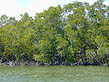
Hydrologic information throughout the Everglades ecosystem is key to the development of restoration strategies and for future evaluation of restoration results. There are significant hydrologic information gaps throughout the Everglades wetlands and estuaries that need to be addressed, particularly along Florida's southwest coast. Among these gaps are flow, water level, and salinity data. This project, in conjunction with the Everglades National Park's (ENP) marine monitoring network, will provide water level, salinity, and flow information at key points within the mangrove zone along the southwest coast of ENP. This project will also include a wetland component designed to provide water level, salinity, and "sheetflow" velocity at selected points within the "sloughs" (flow paths) flowing into the estuaries. Hydrodynamic modelers of the Everglades, Florida Bay, southwest coast estuaries, and other adjacent marine systems, will use these data to calibrate and verify models describing flow patterns throughout ENP. The objective of this project is to describe the salinity patterns in relation to freshwater inflows to the estuaries and tidal exchange with the Gulf of Mexico, to provide support for the USGS Tides and Inflows in the Mangroves of the Everglades model (TIME) and to programs like the Everglades Long Term Ecological Research (LTER). Additionally, other federal and state agencies, universities, and local institutions conducting research in the area will be give access to all the information generated though this study.
Proposals
Work Plans
Project Summaries
Data
Metadata
Publications
Abstracts
Posters
Reports
- 2006 Water Resources Data for the United States Water Year 2006 (Search all reports for the year. Please note individual manuscript files that follow are PDF files which require the FREE Adobe Acrobat Reader® to be read.)
- 2006 Southern Florida Basin, Big Cypress Swamp Subbasin: 02290928 Barron River at Everglades City, FL (PDF file)
- 2006 Southern Florida Basin, Big Cypress Swamp Subbasin: 02290930 Turner River Near Chokoloskee Island, FL (PDF file)
- 2006 Southern Florida Basin, Big Cypress Swamp Subbasin: 02290940 New River at Sunday Bay, FL (PDF file)
- 2006 Southern Florida Basin, Big Cypress Swamp Subbasin: 02290942 Lopez River Near the Lopez Campsite, FL (PDF file)
- 2006 Southern Florida Basin, Everglades Subbasin: 022908205 North River Upstream of Cutoff Near Flamingo, FL (PDF file)
- 2006 Southern Florida Basin, Everglades Subbasin: 022908295 Bottle Creek at Rookery Branch Near Homestead, FL (PDF file)
- 2006 Southern Florida Basin, Everglades Subbasin: 02290878 Broad River Near the Cutoff, FL (PDF file)
- 2006 Southern Florida Basin, Everglades Subbasin: 02290888 Chatham River Near the Watson Place , FL (PDF file)
- 2006 Southern Florida Basin, Everglades Subbasin: 02290918 Lostman's River Below Second Bay, FL (PDF file)
- 2006 Southern Florida Basin, Everglades Subbasin: 251003080435500 McCormick Creek at Mouth, FL (PDF file)
- 2006 Southern Florida Basin, Everglades Subbasin: 251032080432200 Seven Palm Lake Near Flamingo, FL (PDF file)
- 2006 Southern Florida Basin, Everglades Subbasin: 251105080231800 Jewfish Creek at U.S. 1, Key Largo, FL (PDF file)
- 2006 Southern Florida Basin, Everglades Subbasin: 251127080382100 Taylor River at Mouth Near Homestead, FL (PDF file)
- 2006 Southern Florida Basin, Everglades Subbasin: 251209080350100 Mud Creek at the Mouth Near Homestead, FL (PDF file)
- 2006 Southern Florida Basin, Everglades Subbasin: 251241080385300 Upstream Taylor River Near Homestead, FL (PDF file)
- 2006 Southern Florida Basin, Everglades Subbasin: 251253080320100 Trout Creek at Mouth, FL (PDF file)
- 2006 Southern Florida Basin, Everglades Subbasin: 251322080352500 Joe Bay 8W Near Key Largo, FL (PDF file)
- 2006 Southern Florida Basin, Everglades Subbasin: 251338080312600 Joe Bay 1E Near Key Largo, FL (PDF file)
- 2006 Southern Florida Basin, Everglades Subbasin: 251341080291200 Stillwater Creek Near Homestead, FL (PDF file)
- 2006 Southern Florida Basin, Everglades Subbasin: 251355080312800 Joe Bay 2E Near Key Largo, FL (PDF file)
- 2006 Southern Florida Basin, Everglades Subbasin: 251422080271900 Oregon Creek Near Key Largo, FL (PDF file)
- 2006 Southern Florida Basin, Everglades Subbasin: 251433080265000 West Highway Creek, FL (PDF file)
- 2006 Southern Florida Basin, Everglades Subbasin: 251438080333500 Joe Bay 5C Near Key Largo, FL (PDF file)
- 2006 Southern Florida Basin, Everglades Subbasin: 251440080262800 East Highway Creek Near Key Largo, FL (PDF file)
- 2006 Southern Florida Basin, Everglades Subbasin: 251457080395800 Taylor Slough Wetland at E146 Near Homestead, FL (PDF file)
- 2006 Southern Florida Basin, Everglades Subbasin: 251549080251200 Manatee Bay Creek Near Homestead, FL (PDF file)
- 2006 Southern Florida Basin, Everglades Subbasin: 251740080311200 C-111 Wetland Near Homestead, FL (PDF file)
- 2006 Southern Florida Basin, Everglades Subbasin: 251816080232200 Card Sound Canal Near Homestead, FL (PDF file)
- 2006 Southern Florida Basin, Everglades Subbasin: 252019080544800 Upstream North River Near Flamingo, FL (PDF file)
- 2006 Southern Florida Basin, Everglades Subbasin: 252230081021300 Shark River Near Gunboat Island Near Flamingo, FL (PDF file)
- 2006 Southern Florida Basin, Everglades Subbasin: 252551081050900 Harney River Near Flamingo, FL (PDF file)
- 2006 Southern Florida Basin, Everglades Subbasin: 253044080555900 Eden 3 in Everglades National Park, FL (PDF file)
- 2006 Southern Florida Basin, Everglades Subbasin: 253357080594100 Upstream Lostman's River Near Everglades River, FL (PDF file)
|

 South Florida Coastal Real-Time Ground Water Stations
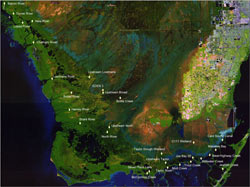 South Florida Coastal Real-Time Surface Water Stations