Weather Story
NWS Sioux Falls, SD

Weather Stories from Neighboring Offices
Weather Story from the NWS office in Aberdeen, SD Weather Story from the NWS office in Grand Forks, ND Weather Story from the NWS office in Twin Cities, MN
Weather Story from the NWS office in Rapid City, SD FSD Weather Story from the NWS office in La Crosse, WI
Weather Story from the NWS office in North Platte, NE Weather Story from the NWS office in Omaha/Valley, NE Weather Story from the NWS office in Des Moines, IA

Graphical depiction of the weather story for today.

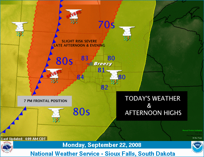
Scattered early morning thunderstorms will tend to diminish by mid to late morning in most locations, but showers and thunderstorms will persist most of the day across eastern North Dakota into northern Minnesota. By late in the day a cold front will make it's way into the region increasing the thunderstorm threat once again. There is a slight risk of severe thunderstorms late this afternoon and evening across central and eastern North Dakota, much of South Dakota, into portions of western Nebraska. It will be breezy across the eastern portion of the region. High temperatures today will range from the 70s across North Dakota and much of Minnesota to the 80s elsewhere.


  • NOAA's National Weather Service
  • Sioux Falls, SD Weather Forecast Office
  • 26 Weather Lane
  • Sioux Falls, SD 57104-0198
  • 605-330-4247
  • Page Author: FSD Webmaster
  • Web Master's E-mail: w-fsd.webmaster@noaa.gov
  • Page last modified: Jun 25th, 2008 17:36 UTC
USA.gov is the U.S. government's official web portal to all federal, state and local government web resources and services.