|
|
 |
Progression of Hurricane Katrina, 2005 (WMS)
|
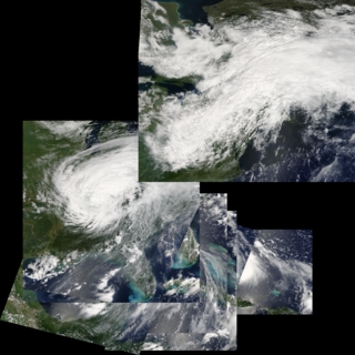
Low earth-orbiting satellites, such as Aqua and Terra, usually see any place on Earth no more than once a day. This sequence of color images from the MODIS instruments on Aqua and Terra shows the progression of Hurricane Katrina, from August 24 to August 31, 2005, whenever one of the two instruments captured the hurricane.
|
|
|
|
Images of Hurricane Katrina aquired by the MODIS instruments on Terra and Aqua from August 24 to August 31, 2005. To get the individual images, follow the 'Sequence' link below. To get the geographical registration information, follow the 'DEPC metadata' link near the bottom of the page.
Available formats:
Sequence
160x80
PNG
30 KB
80x40
PNG
8 KB
1024x1024
PNG
1 MB
320x320
JPEG
69 KB
1024x1024
TIFF
1 MB
How to play our movies
|
|
This product is available through our Web Map Service.
Click here to learn more.
|
|
|
Back to Top
|
|
|
|


