Dora was a long-lived, intense Pacific hurricane. Its only impact to land
was the generation of high surf conditions as it passed south of Hawaii.
a. Synoptic history
Dora originated from a tropical wave that moved off the west coast of Africa
on 23 July. It moved westward across the tropical Atlantic Ocean and the
Caribbean Sea without distinction. By 4 August, the wave was located over
the tropical Pacific Ocean south of the Gulf of Tehuantepec with some
disorganized convection. In the next 24 hours, there was evidence of a
low-level cyclonic circulation in satellite imagery, along with the
formation of a curved convective band west of the center. The system is
estimated to have become Tropical Depression Seven-E at 0000 GMT on 6
August, while located about 290 nautical miles south of Acapulco, Mexico.
The best track begins at this time and is listed in Table 1 and plotted in
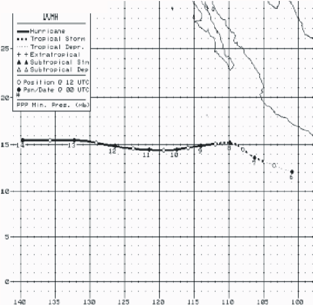
Fig. 1(a) which are the best-track positions in the eastern Pacific basin.
The track is also plotted in Fig. 1(b) which shows the entire track of the
hurricane as it moved across the eastern, central, and western Pacific
basins. The last time a tropical cyclone moved across all three basins was
in 1994, when Hurricane John did so.
During the formation stage, a broad, mid- to upper-level trough covered an
area to the northwest of the system. Over several days, this trough
weakened and was replaced by a substantial anticyclone. The effect of these
features on the track is seen in Figure 1. The motion was
toward the west-northwest on the 6th and 7th and then
became westward for the remainder Dora's track across the eastern and
central Pacific basins. Finally on the 20th in the western Pacific
basin, Dora turned northwestward. It continued this motion until weakening
below depression status on the 23rd.
Despite some initial vertical wind shear from the northeast, the system
steadily intensified. The depression became Tropical Storm Dora late on the
6th, and then reached hurricane strength on the 8th
when a deep and symmetric central dense overcast was observed on satellite
imagery. By this time, the vertical wind shear had decreased. A
small-diameter eye formed on the 9th and Dora is estimated to have
reached its peak intensity of 120 knots at 0000 UTC on the 12th,
with a corresponding central surface pressure of 943 millibars. It weakened
slightly for several hours and again reached 120 knots on 1800 UTC. During
this fluctuation, it is believed that Dora may have experienced a concentric
eyewall cycle as SSMI and infrared satellite imagery showed enhanced
convection occurring at a larger distance from the center. Dora maintained
120 knots this second time until 0600 UTC on the 13th and then
weakened to 100 knots by the 14th when it moved westward into the
central Pacific basin. It is notable that Dora had wind speeds of 100 knots
or more for 96 hours from the 10th through the 14th.
Dora moved across the central Pacific basin from the 14th to the
20th and passed about 200 n mi south of the Hawaiian Islands on
the 15th. The only significant effect to Hawaii was high surf
conditions along the southeast facing shores of the Big Island. The
intensity decreased to 70 knots on the 14th and then increased
back up to 100 knots on the 16th. The final weakening phase then
began and continued as Dora moved westward into the western Pacific basin as
a tropical storm on the 20th. It weakened to a depression and
dissipated on the 23rd several hundred miles north of Wake Island.
b. Meteorological statistics
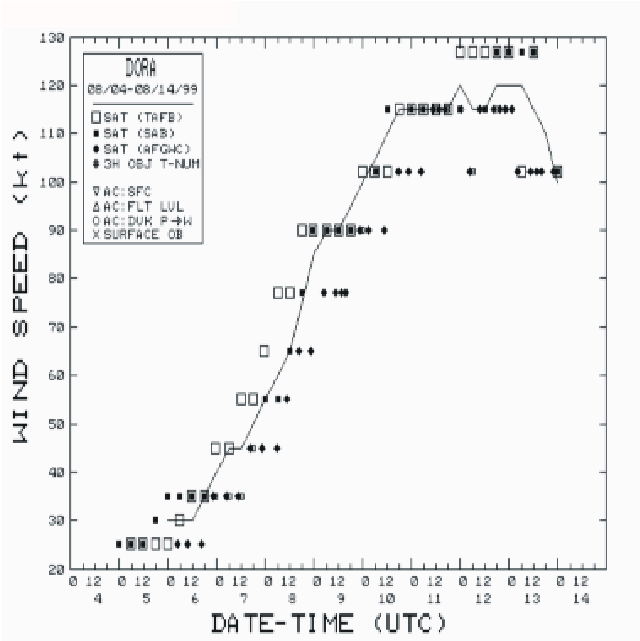
Figure 2 and Figure 3, respectively,
show best track curves of wind speed and central pressure versus time while
the hurricane was located in the eastern Pacific basin. The subjective
satellite Dvorak estimates of wind and pressure from the Tropical Analysis
and Forecast Branch (TAFB), the Satellite Analysis Branch (SAB), and the Air
Force Weather Agency (AFGWC) are plotted on these figures. In addition,
objective Dvorak intensity estimates were near 120 knots on the
12th and 13th. There was no other source of
intensity data in the eastern Pacific basin.
In the central Pacific basin, there were six U.S. Air Force Reserve
reconnaissance missions on the 15th through the 17th
while the hurricane was approaching and passing to the south of Hawaii.
The maximum wind speed of 100 knots at 0600 UTC on the 16th
is based on a 700-millibar flight level wind speed of 114 knots and a
965-millibar central surface pressure reported from an aircraft.
c. Casualty and damage statistics
There are no known casualties or damage associated with this hurricane.
d. Forecast and warning critique
The average National Hurricane Center official track errors for this
hurricane were 9 n mi at 0 hours (30 cases), 32 n mi at 12 hours (28 cases),
56 n mi at 24 hours (26 cases), 76 n mi at 36 hours (24 cases), 95 n mi at
48 hours (22 cases), and 132 n mi at 72 hours (18 cases). These errors are
smaller than the previous ten-year average official track errors in the
eastern Pacific basin. This better-than-average performance is to be
expected with such a smooth westward track.
There were several 72-hour wind speed forecast errors of -35 knots during
the three days prior to Dora reaching its maximum intensity of 120 knots.
The SHIPS intensity guidance model had similar under-forecast errors.
(A)

(B)
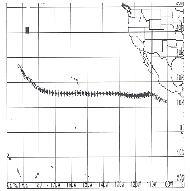
Figure 1.
(A) Best-track positions for Hurricane Dora, 06-14 August 1999, in the
eastern Pacific basin. (B) Approximate position estimates for the entire
track of Hurricane Dora, 06-23 August 1999.

Figure 2.
Best track maximum sustained wind speed curve for Hurricane Dora.

Figure 3.
Best track minimum central pressure curve for Hurricane Dora.
Table 1.
Preliminary Best Track - Hurricane Dora, 06-14 August 1999. Data are also
listed for 14-20 August as provided by the
Central Pacific Hurricane Center
and for 20 -23 August as provided by the
Joint Typhoon Warning Center.
Date/Time
(UTC) |
Position |
Pressure
(mb) |
Wind Speed
(kt) |
Stage |
| Lat. (°N) |
Lon. (°W) |
| 06/0000 | 12.1 | 100.9 | 1007 | 30 | tropical depression |
| 0600 | 12.4 | 102.2 | 1007 | 30 | " |
| 1200 | 12.8 | 103.5 | 1007 | 30 | " |
| 1800 | 13.2 | 104.9 | 1005 | 35 | tropical storm |
| 07/0000 | 13.6 | 106.3 | 1002 | 40 | " |
| 0600 | 14.0 | 107.1 | 999 | 45 | " |
| 1200 | 14.5 | 108.0 | 997 | 45 | " |
| 1800 | 15.0 | 108.8 | 996 | 50 | " |
| 08/0000 | 15.2 | 109.9 | 993 | 55 | " |
| 0600 | 15.2 | 111.0 | 989 | 60 | " |
| 1200 | 15.1 | 112.0 | 987 | 65 | hurricane |
| 1800 | 15.0 | 113.1 | 982 | 75 | " |
| 09/0000 | 14.9 | 114.1 | 974 | 85 | " |
| 0600 | 14.8 | 115.0 | 970 | 90 | " |
| 1200 | 14.7 | 115.9 | 970 | 90 | " |
| 1800 | 14.6 | 116.7 | 967 | 95 | " |
| 10/0000 | 14.5 | 117.5 | 962 | 100 | " |
| 0600 | 14.4 | 118.4 | 958 | 105 | " |
| 1200 | 14.4 | 119.4 | 954 | 110 | " |
| 1800 | 14.4 | 120.5 | 950 | 115 | " |
| 11/0000 | 14.5 | 121.5 | 948 | 115 | ' |
| 0600 | 14.5 | 122.6 | 948 | 115 | ' |
| 1200 | 14.6 | 123.8 | 948 | 115 | " |
| 1800 | 14.7 | 125.1 | 948 | 115 | " |
| 12/0000 | 14.9 | 126.4 | 943 | 120 | " |
| 0600 | 15.0 | 127.8 | 946 | 115 | " |
| 12/1200 | 15.2 | 129.1 | 948 | 115 | hurricane |
| 1800 | 15.4 | 130.6 | 945 | 120 | " |
| 13/0000 | 15.5 | 132.3 | 943 | 120 | " |
| 0600 | 15.5 | 134.0 | 943 | 120 | " |
| 1200 | 15.5 | 135.8 | 946 | 115 | " |
| 1800 | 15.5 | 137.7 | 950 | 110 | " |
| 14/0000 | 15.5 | 139.7 | 960 | 100 | " |
| The following data were provided by the Central Pacific Hurricane Center at Honolulu. |
| 0600 | 15.5 | 141.7 | 975 | 75 | " |
| 1200 | 15.4 | 143.5 | 985 | 70 | " |
| 1800 | 15.3 | 145.4 | 985 | 70 | " |
| 15/0000 | 15.3 | 147.1 | 985 | 70 | " |
| 0600 | 15.4 | 149.0 | 982 | 90 | " |
| 1200 | 15.5 | 150.8 | 978 | 95 | " |
| 1800 | 15.6 | 152.5 | 970 | 95 | " |
| 16/0000 | 15.7 | 154.2 | 965 | 95 | " |
| 0600 | 15.7 | 155.8 | 965 | 100 | " |
| 1200 | 15.6 | 157.4 | 972 | 90 | " |
| 1800 | 15.5 | 159.1 | 980 | 85 | " |
| 17/0000 | 15.5 | 160.8 | 980 | 80 | " |
| 0600 | 15.5 | 162.5 | 985 | 75 | " |
| 1200 | 15.5 | 164.2 | 987 | 75 | " |
| 1800 | 15.5 | 166.0 | 990 | 70 | " |
| 18/0000 | 15.6 | 167.8 | 992 | 65 | " |
| 0600 | 15.7 | 169.6 | 995 | 65 | " |
| 1200 | 15.9 | 171.5 | 995 | 65 | " |
| 1800 | 16.1 | 173.3 | 995 | 65 | " |
| 19/0000 | 16.3 | 174.9 | 995 | 65 | hurricane |
| 0600 | 16.6 | 176.5 | 995 | 65 | " |
| 1200 | 16.9 | 177.8 | 995 | 65 | " |
| 1800 | 17.3 | 179.2 | 995 | 65 | " |
| 20/0000 | 17.9 | 179.4(E) | 996 | 60 | tropical storm |
| The following data were provided by the Joint Typhoon Warning Center at Pearl Harbor. |
| 0600 | 18.4 | 178.3(E) | | 50 | tropical storm |
| 1200 | 19.0 | 177.5(E) | | 45 | " |
| 1800 | 19.6 | 176.6(E) | | 45 | " |
| 21/0000 | 20.4 | 175.4(E) | | 45 | " |
| 0600 | 20.9 | 174.4(E) | | 40 | " |
| 1200 | 21.3 | 173.4(E) | | 40 | " |
| 1800 | 21.8 | 171.8(E) | | 35 | " |
| 22/0000 | 22.5 | 170.8(E) | | 30 | tropical depression |
| 0600 | 23.5 | 169.9(E) | | 30 | " |
| 1200 | 24.1 | 169.2(E) | | 25 | " |
| 1800 | 24.7 | 168.3(E) | | 25 | " |
| 23/0000 | 25.7 | 167.5(E) | | 25 | " |
| 0600 | 26.6 | 167.6(E) | | 25 | " |
| 1200 | 27.5 | 167.5(E) | | 25 | " |
| 1800 | 28.3 | 167.6(E) | | 25 | " |
| |
| 12/0000 | 14.9 | 126.4 | 943 | 120 | minimum pressure |
| 13/0000 | 15.5 | 132.3 | 943 | 120 | minimum pressure |
| 13/0600 | 15.5 | 134.0 | 943 | 120 | minimum pressure |
![[NCEP Logo]](graphics/ncep.gif)