a. Synoptic history
The origins of Fernanda can be traced to a tropical wave that emerged from
the coast of Africa on 1 August. The wave generated little convection as it
moved across the Atlantic and Caribbean. On 10 August, convection increased
as the system crossed Central America into the eastern Pacific Ocean. Further
organization was slow and gradual as the wave continued westward, with the
first Dvorak satellite intensity estimates being made on 15 August. Satellite
animation showed increasing low-level circulation on 16 August, and
scatterometer data from the ERS-2 satellite indicated a well-defined surface
circulation with near 25 kt winds near 0600 UTC 17 August. It is estimated
that Tropical Depression Ten-E formed at this time (
Table 1) about 400 nm south-southwest of Socorro Island,
Mexico.
Further intensification occurred, and the cyclone reached tropical storm
strength on 18 August while centered 450 nm southwest of Socorro Island.
Fernanda reached a peak intensity of 55 kt the next day, followed by
weakening as the storm encountered colder water. The peak intensity was
coincident with a turn from a west-northwest to a west-southwest track which
persisted for the rest of the cyclone's life. While this track carried the
storm over warmer water, increasing easterly wind shear caused continued
weakening. Fernanda weakened to a tropical depression on 21 August and
dissipated as a tropical cyclone on 22 August. The remnant low cloud swirl
persisted and turned back to the east, finally losing its identity about 250
nm west-southwest of Socorro Island on 28 August.
b. Meteorological statistics
The "best track" of Fernanda is given in Table 1
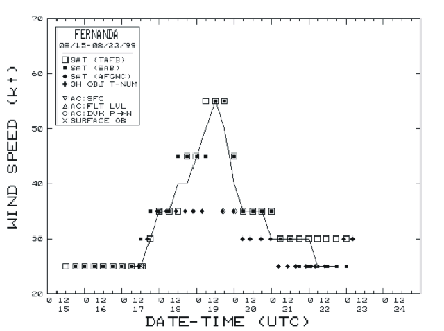
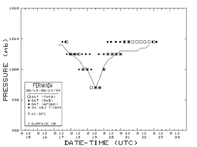
and Figure 1. Figure 2 and
Figure 3 show the best track maximum sustained (1 min
average) surface (10 m elevation) wind speed and minimum central pressure, as
well as the associated observations. These include Dvorak technique position
and intensity estimates from the Tropical Analysis and Forecast Branch
(TAFB), the NOAA/NESDIS Satellite Analysis Branch (SAB), and the Air Force
Weather Agency (AFGWC in the figures).
In addition to helping determine when Fernanda first developed, the ERS-2
satellite was used to determine tropical storm wind radii.
There are no known surface observations of tropical storm force winds.
c. Casualty and Damage Statistics
Fernanda remained at sea throughout its lifetime, and there are no reports of
damage or casualties.
d. Forecast and Warning Critique
Since Fernanda was a tropical storm for less than 72 hr, no verification
statistics are available for that time. The NHC official average track
forecast errors were 38, 80, 98 and 98 nm at 12 (10 cases) , 24 (8 cases), 36
(6 cases) and 48 hr (4 cases) respectively. These errors compare favorably to
the 1988-1997 average of 39, 71, 105 and 137 nm at those times. The GFDL
model had a lower average error than the official forecasts at the 12, 24 and
36 hr periods.
NHC intensity forecast errors were generally less than the 1990-1997 average
except at 48 hr. There was a positive bias (winds overforecast) in all the 48
hr forecasts, and in the 24 and 36 hr forecast after 0600 UTC 18 August. This
was due to Fernanda consistently weakening faster than forecast.
No watches or warnings were issued for Fernanda.
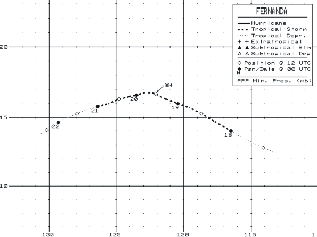
Figure 1.
Best track positions for Tropical Storm Fernanda, 17 - 22 August 1999.

Figure 2.
Best track maximum sustained wind speed curve for Tropical Storm Fernanda,
17-22 August 1999.

Figure 3.
Best track minimum central pressure curve for Tropical Storm Fernanda, 17-22
August, 1999.
Table 1.
Best track, Tropical Storm Fernanda, 17 -22 August 1999
Date/Time
(UTC) |
Position |
Pressure
(mb) |
Wind Speed
(kt) |
Stage |
| Lat. (°N) |
Lon. (°W) |
| 17/0600 | 12.4 | 113.1 | 1008 | 25 | tropical depression |
| 1200 | 12.8 | 114.1 | 1008 | 25 | " |
| 1800 | 13.3 | 115.2 | 1006 | 30 | " |
| 18/0000 | 14.0 | 116.5 | 1005 | 35 | tropical storm |
| 0600 | 14.7 | 117.7 | 1004 | 35 | " |
| 1200 | 15.3 | 118.7 | 1003 | 40 | " |
| 1800 | 15.7 | 119.6 | 1001 | 40 | " |
| 19/0000 | 16.0 | 120.4 | 1000 | 45 | " |
| 0600 | 16.3 | 121.3 | 997 | 50 | " |
| 1200 | 16.7 | 122.1 | 994 | 55 | " |
| 1800 | 16.8 | 122.8 | 997 | 50 | " |
| 20/0000 | 16.6 | 123.5 | 1001 | 40 | " |
| 0600 | 16.5 | 124.1 | 1003 | 35 | " |
| 1200 | 16.3 | 124.8 | 1004 | 35 | " |
| 1800 | 16.0 | 125.6 | 1005 | 35 | " |
| 21/0000 | 15.8 | 126.4 | 1006 | 30 | tropical depression |
| 0600 | 15.6 | 127.1 | 1006 | 30 | " |
| 1200 | 15.3 | 127.9 | 1006 | 30 | " |
| 1800 | 15.0 | 128.6 | 1006 | 30 | " |
| 22/0000 | 14.6 | 129.3 | 1006 | 30 | " |
| 0600 | 14.3 | 129.8 | 1007 | 25 | " |
| 1200 | 14.1 | 130.2 | 1007 | 25 | " |
| 1800 | 13.8 | 130.6 | 1008 | 25 | " |
| 23/0000 | | dissipated |
| |
| 19/1200 | 16.7 | 122.1 | 994 | 55 | minimum pressure |
![[NCEP Logo]](graphics/ncep.gif)