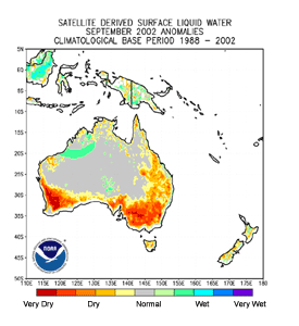
| Drought continued to impact parts of Australia, specifically areas of New South Wales, South Australia and Western Australia. As a result, the Australian Bureau of Agricultural and Resource Economics reduced its crop production estimates for 2002 by 40 percent (CIP report). However, some heavy rains did fall in parts of New South Wales during the week of September 16th. |
larger image
|
larger image
|
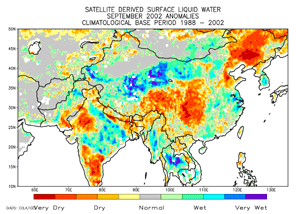
Drought impacted the northern Hebei province of China, with nearly 900,000 people affected by water shortages. Around 163,000 acres of crops have failed and 160,000 machine operated wells have been shut down to prevent the over extraction of ground water (CIP report).
|
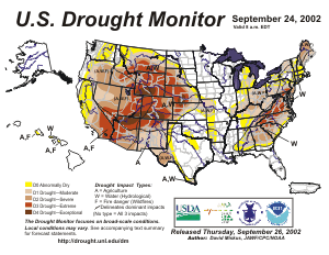
| Severe to exceptional drought continued across parts of the western United States as well as the Southeast in September. Tropical moisture brought significant rainfall to parts of Georgia and the Carolinas, which provided some relief to drought conditions. Beneficial rains across parts of the Four Corners region also helped to relieve some exceptional drought in the Southwest. During the first ten days of September, wildfires were scattered throughout much of the western United States.
|
larger image
|
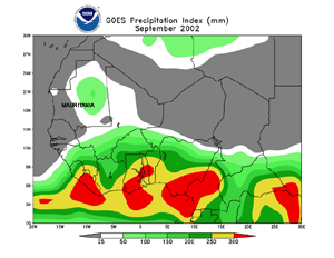
| Long-term drought affected the northwest African nation of Mauritania. On September 1st, the Mauritanian government declared a state of emergency as at least 60,000 people faced serious, imminent food shortages (OCHA). |
larger image
|
Drought in Papua New Guinea has resulted in the adoption of water conservation measures across the Highlands regions. Power cuts occurred in the National Capital District as water rationing affected hydro-electric facilities (CIP report).
larger image
|
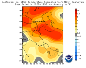
Warm weather across the Caucasus Mountains in southern Russia (east of the Black Sea) was responsible for glacial melt that produced a deadly mudslide in the village of Karmadon, located in North Ossetia-Alania (Associated Press, CIP report). At the end of September, over 100 people remained missing. |


larger image
|
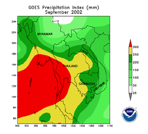
Flooding along the lower stretches of the Mekong River during the last week of August into early September was extensive across parts of Vietnam, Cambodia, Thailand and Laos. River flooding was responsible for over 150 deaths across Indochina, with around 120,000 people in Cambodia evacuated to emergency shelters (Reuters/AP/CIP report). This is the third consecutive year that the Mekong Delta region has experienced serious flooding.
|
In Vietnam, heavy rain during September 19-23rd resulted in flooding across the Ha Tinh and Nghe An provinces, which caused up to 55 deaths (CIP Report). Preliminary damage estimates were around $19.6 million (USD).
larger image
|
A slow moving storm system which tracked across the Mediterranean was responsible for heavy rains across Albania during September 21-26. Nearly double the normal September rainfall occurred in less than a week, causing severe flooding across parts of the country. The Prime Minister declared a "State of Natural Disaster" in nine Albanian provinces, where over 15,000 houses were flooded and over 26,000 hectares (64,000 acres) of agricultral land submerged.
|
Thunderstorms which produced heavy rainfall caused a landslide in the Guatemalan town of San Lucas Toliman on September 13. The landslide was responsible for 18 deaths and the destruction of 10 houses (IFRC).

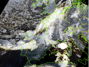
| Showers and thunderstorms which developed along a cold front affected much of southern France during September 7-9. The storms caused flooding that claimed 26 lives, including at least one lightning fatality (Associated Press). The hardest hit area was near the southern French city of Nimes. |
larger image
|
Radar Animation
Courtesy of UCAR
|
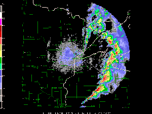
Severe thunderstorms ripped through northern Wisconsin on Labor Day (September 2, 2002) spawning several tornadoes, hail and wind damage. A tornado rated F-3 on the Fujita scale struck Ladysmith, Wisconsin on the afternoon of the 2nd. The storm caused extensive damage, leveling several downtown buildings and knocking down the town water tower. The storm was responsible for 40 injuries and caused $40 million (USD) in damage in the town of 4,000 people (Associated Press/Reuters). |
A tornado struck the Utah town of Manti on September 8th and caused an estimated $1 million (USD) in damage (Associated Press). Tornadoes in Utah are relatively rare, with an average of about 2 per year in the state.
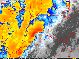
| Thunderstorms preceding a strong cold front brought severe weather and tornadoes on the 20th to areas of Ohio and Indiana. Of at least 50 homes that were destroyed in Indiana, 20 of those were in the town of Martinsville where a tornado struck (Associated Press). According to the state emergency management agency, this was the worst outbreak of severe weather in Indiana since June 1990. |
larger image
|
Severe thunderstorms ahead of a cold front brought large hail, damaging winds and at least 2 confirmed tornadoes to three provinces of eastern South Africa on September 9th.


Radar Animation
Courtesy of UCAR
|
Hurricane Isidore developed as tropical depression in the western tropical Atlantic and tracked northwestward across the Caribbean Sea reaching tropical storm strength on the 18th as it passed near Jamaica. Isidore reached hurricane status on the 19th as it brushed the Cayman Islands and crossed into western Cuba by the 21st, locally dumping over 600 mm (24 inches) of rain along with maximum sustained winds near 165 km/hr (~90 knots or 105 mph). Isidore then moved westward, making landfall along the northern Yucatan Peninsula in Mexico on the 22nd with maximum sustained winds near 205 km/hr (~110 knots or 125 mph). |
At least 2 people were killed in Mexico from Isidore, and over 300,000 left homeless as strong winds and flooding rains caused significant damage (Associated Press). Isidore weakened to a tropical storm while over land, and remained below hurricane strength as it made its final landfall in the United States on the 26th along the southeast coast of Louisiana. Rainfall in New Orleans locally exceeded 500 mm (~20 inches), resulting in widespread flooding. Wind speeds exceeding 95 km/hr (~50 knots or 60 mph) were observed early on the 26th in coastal areas of Louisiana causing power outages to over 30,000 households. Widespread heavy rains locally exceeding 50-100 mm (~2-4 inches) spread well inland, affecting much of the Tennessee Valley region.
larger image
|
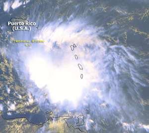
Tropical Storm Lili developed as a tropical depression in the central tropical Atlantic Ocean on the 21st and became a tropical storm on the 23rd as it passed through the Windward Islands. On Barbados, 139 homes were badly damaged and 275,000 people lost electric power as maximum sustained winds were near 95 km/hr (~50 knots or 55 mph) (Associated Press). Lili dissipated south of Haiti on the 26th but regained its intensity and skirted the north coast of Jamaica on the 29th. Lili reached hurricane strength on the 30th, passing near the Cayman Islands and crossing western Cuba on October 1. Lili was the second hurricane in less than 2 weeks to strike western Cuba, and it forced the evacuation of thousands of people. |
Tropical Storm Julio developed as a tropical depression about 165 km (100 miles) south of Zihuatanejo, Mexico on the 25th. Julio became a tropical storm later the same day before making landfall near Lazaro Cardenas. Maximum sustained winds were near 65 km/hr (~35 knots or 40 mph) as the storm came ashore, along with torrential rains.
|
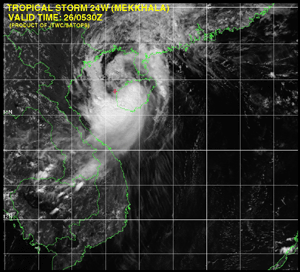
Tropical Storm Mekkhala developed as a tropical depression in the South China Sea on the 23rd and became a tropical storm on the 24th with maximum sustained winds near 100 km/hr (55 knots or 65 mph). The storm crossed over the island of Hainan on the 25th before re-emerging in the Gulf of Tonkin on the 26th. Mekkhala crossed into Guangxi province of southeastern China on the 27th as a minimal tropical storm. |
larger image
|
|
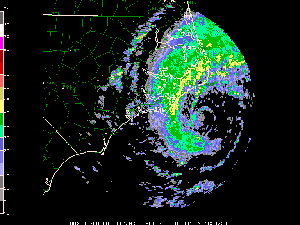
Tropical Storm Hanna developed as a tropical depression in the eastern Gulf of Mexico on September 12th and became a tropical storm the following day. Maximum sustained winds reached 45 knots (52mph) on the 14th just prior to landfall. The storm was very quickly downgraded to a tropical depression as it moved ashore near Mobile, Alabama on the 14th. Extremely heavy rain accompanied the storm as it moved to the northeast and led to some areas of flooding, especially in parts of southwest Georgia. Donalsonville in Seminole County, Georgia received 14.59 inches (370mm) of rain in a 24 hour-period, most of which fell on Sunday morning (15th) according to the National Weather Service.
|

larger image
|
larger image
|
Typhoon Rusa developed in the western Pacific Ocean on August 22nd and became a typhoon by the 24th. Rusa crossed the Japanese island of Amami O Shima on August 29th with maximum sustained winds near 150 km/hr (~80 knots or 90 mph). |
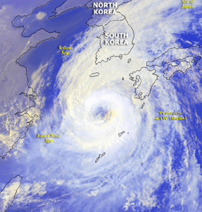
Rusa recurved northward across the East China Sea before making landfall along the south coast of South Korea on August 31st with maximum sustained winds of 130 km/hr (70 knots or 80 mph). The typhoon was the worst to strike South Korea since 1959, causing 200 deaths and dumping between 300 and 500 mm (11.8 and 19.7 inches) of rain on parts of South and North Korea in less than 12 hours (ENS). Rusa was the most costly storm in South Korean history, causing an estimated $200 million (USD in damage. The typhoon damaged more than 20,000 buildings and washed away at least 200 bridges and highways (ENS/OCHA).
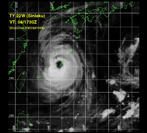
| Typhoon Sinlaku developed in the East Mariana Basin on August 28 and became a typhoon on the 30th. Sinlaku crossed the Japanese island of Okinawa on September 4th with maximum sustained winds of 175 km/hr (95 knots or 110 mph). Winds in the city of Kadena gusted to 183 km/hr (99 knots or 114 mph) as the typhoon passed by. Sinlaku tracked into Zhejiang province on the 7th, making landfall near the city of Wenzhou. The storm prompted the evacuation of over 300,000 people and was blamed for at least 9 deaths (Reuters). |
larger image
|
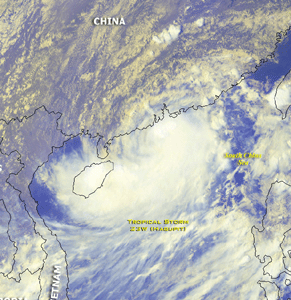
| Tropical Storm Hagupit originated in the South China Sea on September 10th and tracked into China's Guangdong province on the 11th with maximum sustained winds of 85 km/hr (~45 knots or 50 mph). In the city of Hong Kong, government offices and the stock exchange were closed as heavy rains and gusty winds affected the city. In the Jiangxi province, flooding associated with the storm destroyed 4,000 houses and flooded 159 villages. Approximately 180,000 people were affected by Tropical Storm Hagupit and over 270,000 acres of farmland destroyed (Associated Press). |
larger image
|
larger image
|
Hurricane Gustav developed as a subtropical depression northeast of the Bahamas on the 8th before reaching subtropical storm strength later the same day. Gustav affected eastern North Carolina on the 10th, dumping 76-152 mm (3-6 inches) of rain and producing wind gusts over 65 km/hr (40 mph or 35 knots). The storm became a hurricane on the 11th as it pulled away from Mid-Atlantic coast. As Gustav approached the Canadian Maritimes, it merged with a low pressure system approaching from New England. Very heavy rains and strong winds gusting over 85 km/hr (45 knots or 50 mph) affected Nova Scotia and Newfoundland during the 11th and 12th. |
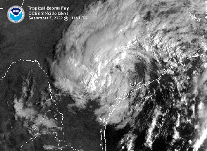
| Tropical Storm Fay developed off the Texas coast on the 5th and made landfall between Houston and Corpus Christi on the 7th. The heaviest rainfall occurred south of Houston and Galveston, where locally more than 10 inches of were reported. |
larger image
|
larger image
|
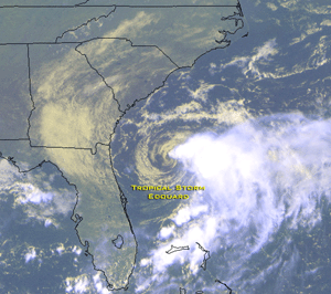
Edouard developed off the east coast of Florida on the 1st and became a tropical storm on the 2nd. The storm came ashore on the 5th across the northeast Florida coastline with gusty winds and locally heavy downpours of rain. Edouard had weakened into a depression as it moved into the northeastern Gulf of Mexico by late on the 5th and dissipated on the 6th. |
For the latest official advisories and information on tropical systems in the western Pacific, please refer to the Joint Typhoon Warning Center. In the central Pacific, the latest information can be obtained from the Central Pacific Hurricane Forecast Center, while the latest advisories on Atlantic and eastern Pacific systems are available from the National Hurricane Center.

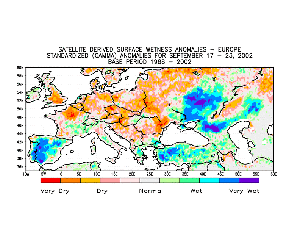
| A low pressure system that affected the Iberian Peninsula brought heavy rain to parts of Spain during the 17th-23rd. Heavy rain on the 17th produced street flooding in Seville, with over 100 mm (~4 inches) in Moron de la Frontera. This is more than 75 mm (3 inches) above average for the entire month of September. |
larger image
|

No reports received during September 2002
References:
Basist, A., N.C. Grody, T.C. Peterson and C.N. Williams, 1998: Using the Special Sensor Microwave/Imager to Monitor Land Surface Temperatures, Wetness, and Snow Cover. Journal of Applied Meteorology, 37, 888-911.
Peterson, Thomas C. and Russell S. Vose, 1997: An overview of the Global Historical Climatology Network temperature data base. Bulletin of the American Meteorological Society, 78, 2837-2849.
For all climate questions other than questions concerning this report, please contact the National Climatic Data Center's Climate Services Division:
Climate Services Division
NOAA/National Climatic Data Center
151 Patton Avenue, Room 120
Asheville, NC 28801-5001
fax: 828-271-4876
phone: 828-271-4800
email: ncdc.orders@noaa.gov
For more information, refer also to ...
September 2002 Climate
Watch
September
2002 U.S. City and State Extremes
2002
Atlantic Hurricanes
2002 U.S. Wildfire
Summary
SSMI Derived Products
Global Historical Climatology Network (GHCN)
The Blended GHCN - SSM/I Product
The Global Temperature Anomalies
CLIMVIS - Global Summary of the
Day
CAMS data provided by the Climate Prediction Center
Geographic Reference Maps (pdf format)
For further information on the historical climate perspective presented in this report, contact:
Scott Stephens
NOAA/National Climatic Data Center
151 Patton Avenue
Asheville, NC 28801-5001
fax: 828-271-4328
email: Scott.Stephens@noaa.gov
-or-
Jay Lawrimore
NOAA/National Climatic Data Center
151 Patton Avenue
Asheville, NC 28801-5001
fax: 828-271-4328
email: Jay.Lawrimore@noaa.gov

 NCDC / Climate
Monitoring / Climate
of 2002 / Hazards / Search / Help NCDC / Climate
Monitoring / Climate
of 2002 / Hazards / Search / Help
http://www.ncdc.noaa.gov/oa/climate/research/2002/sep/hazards.html
Downloaded Saturday, 20-Sep-2008 12:39:59 EDT
Last Updated Thursday, 14-Jul-2005 08:34:05 EDT by Scott.Stephens@noaa.gov
Please see the NCDC Contact Page if you have questions or comments.
|


