[Atlantic Oceanographic and Meteorological Laboratory]


About AOML
About HRD
Programs
Data Sets
Weather Information
 yellow triangle bulletHurricane FAQ
 yellow triangle bulletAtl. TC Outlook
 yellow triangle bulletStorm Shutters
 yellow triangle bulletWeather Room
 yellow triangle bulletCurrent Weather
 yellow triangle bulletHurr. Awareness
What's New
Links

OAR Logo
OAR


NOAA Aircraft Operations Center Logo
NOAA Aircraft Operations Center

Site Map

Staff Data Center Contact  Information

Research Divisions


Hurricane Research Division

Back to Basic Definitions Page | Back to Main FAQ Page

Subject: A9) What is a "CDO" ?
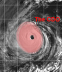
CDO delimited NRL - Monterey
Contributed by Chris Landsea

"CDO" is an acronym that stands for "central dense overcast". This is the cirrus cloud shield that results from the thunderstorms in the eyewall of a tropical cyclone and its rainbands. Before the tropical cyclone reaches hurricane strength (33 m/s, 64 kts, 74mph), typically the CDO is uniformly showing the cold cloud tops of the cirrus with no eye apparent. Once the storm reaches the hurricane strength threshold, usually an eye can be seen in either the infrared or visible channels of the satellites. Tropical cyclones that have nearly circular CDO's are indicative of favorable, low vertical shear environments.

Back to Basic Definitions Page | Back to Main FAQ Page
[Horizontal Rule]

[OAR/DOC/NOAA Logos] Atlantic Oceanographic and Meteorological Laboratory Logo [United States Department of Commerce] [Atlantic Oceanographic and Meteorological Laboratory] Atlantic Oceanographic and Meteorological Laboratory Logo [National Oceanic and Atmospheric Administration] [Office of Oceanic and Atmospheric Research] Department of Commerce Logo National Oceanic and Atmospheric Administration Logo Ocean and Atmospheric Research Logo

  Disclaimer | Privacy Notice
  DOC/NOAA/AOML/
HRD

hrdwebmaster@aoml.noaa.gov