![[Atlantic Oceanographic and Meteorological Laboratory]](https://webarchive.library.unt.edu/eot2008/20080917162652im_/http://www.aoml.noaa.gov/hrd/hrd_top_logo7.jpg)
| Staff | Data Center | Contact Information |
| Subject: A2) What is a "Cape Verde" hurricanes? 
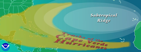
Cape Verde-type hurricanes are those Atlantic basin tropical cyclones that develop into tropical storms fairly close (<1000 km [600 mi] or so) of the Cape Verde Islands and then become hurricanes before reaching the Caribbean. (That would be my definition, there may be others.) Typically, this may occur in August and September, but in rare years (like 1995) there may be some in late July and/or early October. The numbers range from none up to around five per year - with an average of around 2. |
![[OAR/DOC/NOAA Logos]](https://webarchive.library.unt.edu/eot2008/20080917162652im_/http://www.aoml.noaa.gov/hrd/oar_noaa_doc_logos3.jpg)


