

|
Current Events Data & Products Purchase Climate Info |
|
|||||

July 2008
Hurricane Dolly, the Atlantic's second hurricane for the 2008 season, strengthened to a category 2 hurricane before lashing the U.S.-Mexico border. Additional information can be found below.

Moderate to severe drought conditions persisted across parts of the Hawaiian Islands and the western, central, and southeastern parts of the continental U.S. Drought conditions depleted across western North Dakota, where extreme drought developed. Extreme to exceptional drought continued across parts of southern Texas, the southern High Plains, and the southern Appalachians. As of July 29, 31% of the western U.S., 46% of the South, 23% of the High Plains, 59% of the Southeast, and 28% of the contiguous U.S. were in moderate to exceptional drought, according to the U.S. Drought Monitor. For a complete drought analysis across the United States, please see the U.S. drought page.
Across China, drought conditions slightly improved across the northern Xinjiang and Gansu provinces, and parts of Ningxia and the Inner Mongolia provinces, where conditions dropped from severe to moderate (Beijing Climate Center).

Heavy rain fell across parts of South Africa during July 4-7, prompting widespread floods, causing mudslides, and forcing hundreds of people to evacuate affected areas. According to reports, the worst hit area was Cape Town where many were left homeless (BBC News).
Across southwestern China, torrential rain fell during the first week of July. The heavy rain triggered mud and rock slides that affected the Liangshan area in the Sichuan province. Nine people died and six were missing (AFP). Further rain fell across southern China during July 11-13, causing widespread floods that affected more than 360,000 people. The floods destroyed houses, roads, and agricultural land (BBC News).
Heavy monsoon rains affected northern India and Bangladesh during July 5-14. In southeast Bangladesh, the heavy rains triggered deadly landslides and floods, killing 20 people and affecting more than 20,000 (AFP). In northern India, the monsoonal rains prompted flash floods that displaced more than 50,000 people in the State of Assam and inundated nearly 50 villages in the district of Lakimpur (AFP). Fourteen people lost their lives (Associated Press).
In Nepal, heavy monsoon rains during the first half of the month caused flash floods and landslides across the region, killing 11 people. The worst incident occurred when five people were buried by a landslide in the Dhading district (DPA).
Heavy rainfall during July 23-26 in South Korea produced deadly floods and landslides that affected nearly 1,240 people and were responsible for seven fatalities. The heavy downpours damaged about 620 houses and inundated nearly 1,220 hectares (3,015 acres) of farmland (Associated Press/BBC News).
Storms in eastern Europe produced heavy rain that fell across parts of Ukraine and Romania during July 25-29. The copious rainfall caused the Prut and Dniestr rivers to flow over their banks, flooding nearly 50,000 homes, affecting over 20,000 people, and destroying thousands of acres of agricultural land (BBC News). According to reports, 30 fatalities were reported in Ukraine, while Romania reported four fatalities (Reuters).
In western Japan, torrential rain produced widespread floods and mudslides that prompted the evacuation of 50,000 people during July 27-28. According to reports, more than 102 mm (4 inches) of rain fell in a period of two hours (Associated Press). Hundreds of homes were damaged and four fatalities were blamed on the heavy rainfall (BBC News).

Severe storms affected Oslo, Norway's capital, on July 5. The storms brought torrential rain that caused widespread floods which paralyzed traffic. Winds gusting near 97 km/hr (60 mph or 52 knots) brought down trees and power lines (BBC News).
In the U.S., severe storms spawned a deadly tornado on July 24 in central New Hampshire. About 100 homes were damaged with several others completely destroyed. The strong winds brought down trees and power lines, leaving 6,000 homes without power. One fatality was reported (Associated Press/Reuters).

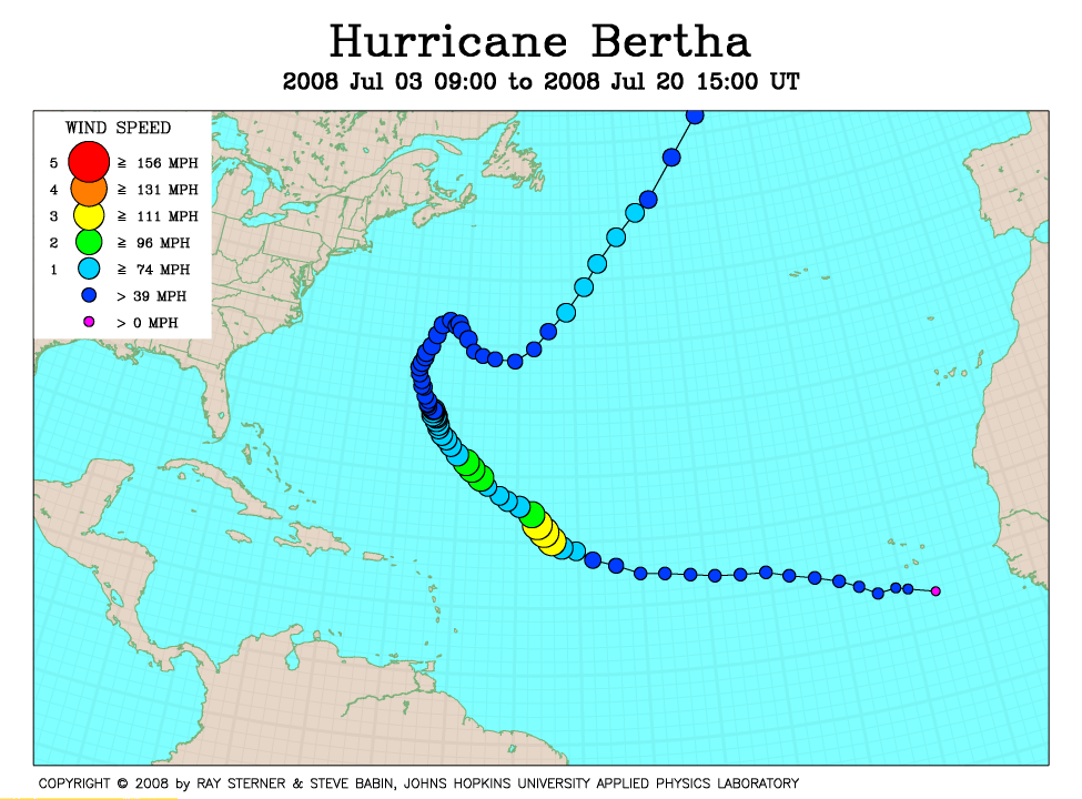
Hurricane Bertha, the Atlantic's first hurricane for the 2008 season, developed in the Atlantic Ocean on July 3. The storm reached peak intensity on July 7 with maximum sustained winds near 193 km/hr (120 mph or 104 knots), but as it traveled toward Bermuda, Bertha weakened into a tropical storm. Although Bertha did not make landfall, Bermuda was battered by the storm's heavy rain and strong winds, causing roads to be flooded and leaving 7,500 people without electricity (Associated Press). Bertha was the longest-lived July Atlantic tropical storm when it entered its 16th day on July 19. The second longest-lived July tropical storm was Storm Number 2 in 1960, lasting just over 12 days (Associated Press/BBC News).
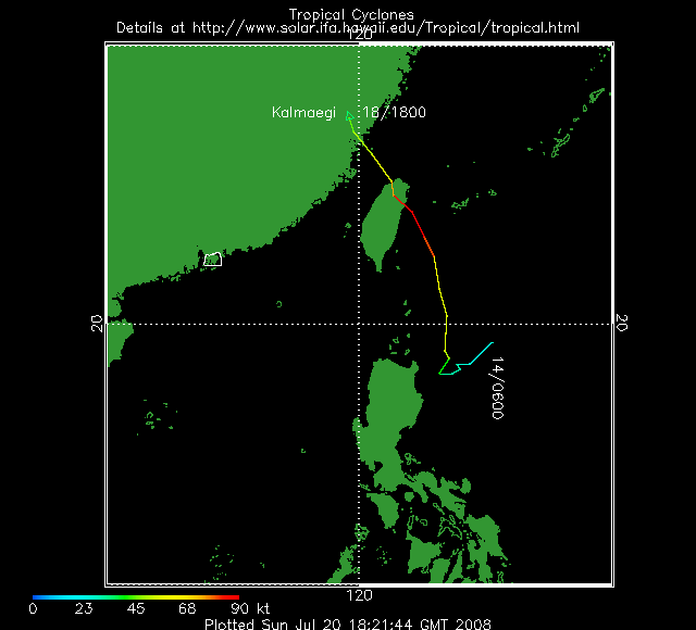
Typhoon Kalmaegi developed as a depression in the western Pacific Ocean, east of the Philippine Islands, on July 14 and reached tropical storm strength on the 15th. The storm strengthened monsoonal rains in the Philippines, resulting in floods that affected thousands of people (BBC News). Kalmaegi reached typhoon peak intensity on July 17 with maximum sustained winds near 167 km/hr (104 mph or 90 knots). Later that day, the storm made landfall on the island of Taiwan, quickly weakening to a tropical storm. The storm lashed the island with heavy downpours that prompted flash floods and landslides that claimed the lives of 18 people and left seven others missing (Reuters/AFP). According to reports, the city of Taichung received a total of 413 mm (16 inches) of rain on the 17th, while other parts of southern Taiwan received as much as 1,100 mm (43 inches) (BBC News). The damages across Taiwan were estimated to be 16 million U.S. dollars (Reuters/AFP). Kalmaegi made a second landfall on the southeastern coast of China on July 18, affecting 360,000 people in the Fujian province (Reuters).
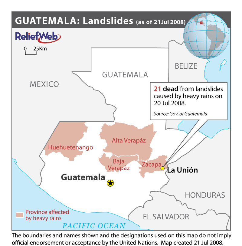
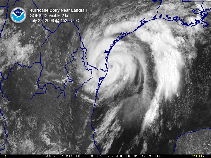
Hurricane Dolly, the Atlantic's second hurricane for the 2008 season, developed as a tropical storm in the western Caribbean Sea on July 20. The storm made landfall in the Yucatan Peninsula on July 21 with maximum sustained winds near 80 km/hr (49 mph or 43 knots). The tropical storm brought heavy rains to parts of Guatemala where deadly landslides were triggered, killing 21 people (RNW). Dolly moved towards the warm waters of the Gulf of Mexico where it strengthened to a category 2 hurricane with maximum sustained winds near 160 km/hr (100 mph or 87 knots) on the 23rd. Later that same day, Dolly made a second landfall in the South Padre Island, southern Texas. The storm lashed the U.S.-Mexico border with strong winds that brought down trees and power lines, and brought heavy rain that caused extensive flooding (Associated Press/AFP). One fatality was reported and nearly 250,000 people were left without drinking water in Mexico. Dolly was downgraded to a tropical depression as it moved further inland on July 25. Dolly's remnants caused heavy rainfall that triggered flash floods across parts of New Mexico, killing one person, flooding nearly 60 homes, and destroying 12 bridges (Reuters).
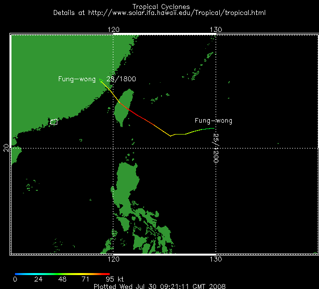
Typhoon Fung-Wong developed as a tropical storm in the northwestern Pacific Ocean on the 25thh. Fung-Wong attained typhoon strength on the 26th, but reached its peak intensity on the 27th with maximum sustained winds near 176 km/hr (109 mph or 95 knots). The storm's outer rain bands intensified seasonal monsoon rains in the northern Philippines, causing widespread floods and landslides that killed four people and left five others missing (Reuters). On July 28 Fung-Wong made its first landfall in Taiwan, the second typhoon to hit in less than two weeks. The typhoon lashed the island with ferocious winds and heavy downpours that triggered floods and landslides. According to reports, the storm dumped more than 838 mm (33 inches) in Hualien, located in Taiwan's east coast. Fung-Wong was responsible for electrical losses for more than 43,000 homes, two fatalities, and an estimated 5.3 million U.S. dollars in agricultural losses (Associated Press). The storm weakened to a tropical storm as it left the island. Over 600,000 people were evacuated in China's southeastern coast as Fung-Wong headed towards the Chinese mainland, where it made its second landfall (AFP).
For 2008 basin tropical cyclone statistics, please refer to the following:
Australian Basin
North Indian Ocean Basin
Western North Pacific Basin
South Pacific Basin
South Indian Ocean Basin
Northeast Pacific Ocean Basin
Atlantic Basin

No reports of significant extratropical cyclones were received during July 2008.

No reports of significant winter weather were received during July 2008.
For all climate questions other than questions concerning this report, please contact the National Climatic Data Center's Climate Services Division:
Climate Services Division
For more information, refer also to:
Selected U.S. City and State Extremes
2008 Atlantic Hurricanes
2008 East Pacific Hurricanes
2008 U.S. Wildfire Summary
Global Historical Climatology Network (GHCN)
The Global Temperature Anomalies
CLIMVIS - Global Summary of the Day
CAMS data provided by the Climate Prediction Center
Tropical Rainfall Measuring Mission (TRMM) - NASA
Relief Web
Geographic Reference Maps (pdf format)
For further information on the historical climate perspective presented in this report, contact:
Ahira Sánchez-Lugo


