a. Synoptic history
The genesis of Tropical Storm Nadine resulted from the interaction of a
strong upper-level trough and a tropical wave. Water vapor imagery showed a
distinct and nearly stationary upper-trough extending northeastward from the
Leeward Islands across the Atlantic for several days. A cut-off low
generated within the trough, moved southwestward, and interacted with a
tropical wave that reached the area on 16 October. The system as a
whole began to move slowly westward with increasing convection and on the
17th, a broad low to middle level circulation became apparent on
visible images. However, it was not until the 19th, when the
system became stationary, that ship reports indicated that a surface
circulation had developed. It is estimated that a tropical depression
formed about 600 n mi southeast of Bermuda at 1200 UTC 19 October.
The depression moved slowly northward and then northeastward around the
periphery of the subtropical ridge and ahead of a cold front. The
thunderstorm activity became better organized with increasing outflow while
the shear relaxed. Based on satellite Dvorak intensity numbers, it is
estimated that the depression became Tropical Storm Nadine at 1200 UTC on
the 20th. Nadine reached a peak intensity of 50 knots and a
minimum pressure of 999 mb at 0000 UTC on the 21st when a possible
eye-like feature and an impressive outflow were observed on satellite
imagery. Thereafter, the shear increased and convection began to weaken.
Nadine interacted with a frontal zone and became a weak extratropical low at
0000 UTC 22 October while moving northeastward. It was then absorbed by a
much larger frontal low. The best track is listed in Table 1 and is plotted
in Fig. 1.
b. Meteorological statistics
Figure 2 depicts the best track curves and data plots
of the maximum sustained 1-min surface winds and minimum central pressure as
a function of time. These plots are primarily based on Dvorak satellite
classification estimates. A report of 33 knots from the southeast from the
vessel Prince of Waves located just east of the cloud system center
was used to initiate tropical depression advisories.
c. Casualties and damages
>
No casualties or damages were associated with Nadine.
d. Forecast and warning critique
There were too few forecasts associated with Nadine to conduct a meaningful
quantitative evaluation. The NCEP global model correctly indicated the
development of a tropical cyclone in the area well in advance.
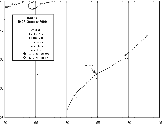
Figure 1.
Best track positions for Tropical Storm Nadine, 19-21 October, 2000.
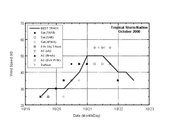
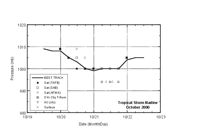
Figure 2.
Best track maximum sustained wind speed and minimum central pressure for
Tropical Storm Nadine.
Table 1.
Best track for Tropical Storm Nadine, 19-21 October, 2000.
Date/Time
(UTC) | Position |
Pressure
(mb) |
Wind Speed
(kt) | Stage |
| Lat. (°N) | Lon. (°W) |
| 19 / 1200 | 26.2 | 59.9 | 1009 | 25 | tropical depression |
| 19 / 1800 | 27.5 | 59.4 | 1008 | 30 | " |
| 20 / 0000 | 28.7 | 58.8 | 1008 | 30 | " |
| 20 / 0600 | 29.7 | 58.0 | 1005 | 30 | " |
| 20 / 1200 | 30.4 | 57.2 | 1003 | 35 | tropical storm |
| 20 / 1800 | 31.4 | 56.3 | 1000 | 40 | " |
| 21 / 0000 | 32.4 | 55.2 | 999 | 50 | " |
| 21 / 0600 | 33.3 | 53.5 | 1000 | 50 | " |
| 21 / 1200 | 34.1 | 52.3 | 1000 | 50 | " |
| 21 / 1800 | 34.8 | 51.3 | 1000 | 45 | " |
| 22 / 0000 | 35.7 | 50.5 | 1004 | 40 | extratropical |
| 22 / 0600 | 37.0 | 49.0 | 1005 | 40 | " |
| 22 / 1200 | 39.0 | 47.0 | 1005 | 35 | " |
| 22/1800 | | absorbed by a frontal low |
| |
| 21 / 0000 | 32.4 | 55.2 | 999 | 50 | minimum pressure |
![[NCEP Logo]](graphics/ncep.gif)


