Isaac was a Cape Verde hurricane that followed a long, parabolic path over
the eastern half of the Atlantic. Its maximum sustained winds reached an
estimated 120 kt, tying it with Keith for the strongest hurricane of the
season.
a. Synoptic History
A strong tropical wave emerged from western Africa on 20 September with some
curvature in the associated deep convective clouds. The system produced a
very well-defined lower-tropospheric wind shift in the time section from
Dakar, Senegal. Later that day, the system was given an initial Dvorak
classification. On the following day, the cloud pattern became better
organized and a tropical depression (Thirteen) formed, a couple hundred
miles to the south of the Cape Verde Islands
(Table 1 and Figure 1).
A mid-tropospheric ridge was present over the eastern Atlantic to the north
of the tropical cyclone, and this provided a west-northwestward steering for
several days. Vertical wind shear was weak, and this allowed the system to
gradually strengthen into Tropical Storm Isaac by 0000 UTC 22 September.
Strengthening continued, and Isaac became a hurricane around 1200 UTC on the
23rd, when a faint eye was evident on visual satellite imagery.
Soon thereafter, the eye became much better defined on the images, and the
hurricane quickly strengthened to 105 kt by 0000 UTC 24 October. Afterwards
on the 24th, the cloud pattern became less organized; core convection became
less symmetric and the eye was not as well-defined as it had been the day
before. This appeared to be mainly the result of internal fluctuations, as
the large-scale atmospheric environment remained favorable. Isaac's winds
decreased to about 90 knots on the 25th, when west-southwesterly
vertical shear became more evident over the system; slightly cooler ocean
waters may have also played a role in the weakening of the hurricane. By
around 1200 UTC on the 26th, the low-cloud center of Isaac was
near the southwest edge of the main area of deep convection, and the
hurricane's winds had decreased to an estimated 75 kt. Later on the
26th, the shear relaxed somewhat, and deep convection became
organized more symmetrically around the center. Isaac re-strengthened on the
27th. A distinct eye again became visible, and Isaac re-attained
category three status around 0000 UTC 28 September. The hurricane turned
toward the northwest about that time. Isaac continued to intensify, and
reached its peak strength of 120 knots, category four on the
Saffir-Simpson Hurricane Scale, around 1800 UTC on the 28th.
Not long after reaching its maximum intensity, the hurricane turned
north-northwestward. Continuing its movement around the western periphery
of a mid-tropospheric anticyclone, Isaac turned northward and then
north-northeastward. The center passed about 440 n mi east of Bermuda on the
29th. When the cyclone moved over cooler waters, the maximum
winds gradually decreased, and were down to category one intensity on the
30th. By this time, Isaac was accelerating northeastward. The
system weakened to a tropical storm on 1 October, and became extratropical
later that same day. Isaac's remnant, a strong extratropical cyclone with
winds of 55 to 60 kt, moved rapidly east-northeastward over the Atlantic.
By 3 October, the cyclone turned north-northeastward, skirting the western
British Isles. The system's maximum winds had decreased to near 45 knots by
this time. Early on 4 October, the cyclone merged with a larger
extratropical low to the north of Scotland.
b. Meteorological Statistics
Table 1
lists the best track positions and intensities of Isaac at
six-hourly intervals. Figure 1
is a display of this track. Figure 2 and
Figure 3
depict the curves of maximum one-minute average "surface" (10 m above ground
level) wind speed and minimum central sea-level pressure, respectively, as
functions of time. Also plotted are the observations on which the curves
are based. These consist of Dvorak-technique estimates using satellite
imagery by the Tropical Analysis and Forecast Branch (TAFB), the Satellite
Analysis Branch (SAB), and the U.S. Air Force Weather
Agency (AFWA).
Isaac's maximum intensity, 120 kt, is based on a blend of both subjective
and objective Dvorak intensity estimates. Subjective Dvorak classifications
around 1800 UTC 28 September gave an estimate of 115 kt. However, the
three-hourly average of objective Dvorak T-numbers around that time
corresponds to 125 kt.
After losing tropical characteristics, Isaac lashed portions of the western
British Isles with winds near gale force on 3 October.
c. Casualty and Damage Statistics
Even though Isaac remained far to the east of the U.S. eastern seabord,
swells generated by this large and powerful hurricane caused a boat with
four passengers to capsize in Moriches Inlet (Long Island), New York on 30
September. One of the passengers, a 54-year old Bronx man, drowned.
d. Forecast and Warning Critique
Excluding the tropical depression and extratropical stages of Isaac, the
average official track forecast errors were 29, 52, 78, 101, and 173 n mi at
12, 24, 36, 48, and 72 h respectively. These errors are smaller than the
most recent ten-year averages (46, 85, 122, 158, and 235 n mi respectively).
For all forecast times, the GFDI model and the GUNS ensemble produced lower
track errors than the official forecast. Table 2
summarizes the performance
for several of the track models and the official track forecasts. Overall
the numerical guidance was quite consistent, with the models
showing the northward turn well in advance.
The mean absolute wind speed errors for the official forecasts were 8, 14,
18, 20, and 18 kt for 12, 24, 36, 48, and 72 h respectively. At 12 and 72 h
these mean intensity errors are comparable to the latest ten-year averages,
however for 24 h through 48 h the mean intensity errors for Isaac were
several knots higher than the longer-term averages. In general, the
official forecasts under-predicted the rate of Isaac's strengthening and
weakening. The SHIPS guidance showed similar biases.
Table 1.
Best track, Hurricane Isaac, 21 September - 1 October 2000.
Date/Time
(UTC) | Position |
Pressure
(mb) |
Wind Speed
(kt) | Stage |
| Lat. (°N) | Lon. (°W) |
| 21 / 1200 | 11.5 | 23.0 | 1008 | 30 | tropical depression |
| 21 / 1800 | 11.9 | 24.5 | 1008 | 30 | " |
| 22 / 0000 | 12.3 | 25.9 | 1005 | 35 | tropical storm |
| 22 / 0600 | 12.7 | 27.2 | 1001 | 40 | " |
| 22 / 1200 | 13.1 | 28.7 | 1000 | 45 | " |
| 22 / 1800 | 13.5 | 30.1 | 1000 | 45 | " |
| 23 / 0000 | 13.7 | 31.2 | 997 | 50 | " |
| 23 / 0600 | 13.9 | 32.3 | 994 | 55 | " |
| 23 / 1200 | 14.3 | 33.2 | 984 | 70 | hurricane |
| 23 / 1800 | 14.6 | 34.2 | 973 | 85 | " |
| 24 / 0000 | 14.9 | 35.0 | 960 | 105 | " |
| 24 / 0600 | 15.1 | 35.8 | 960 | 100 | " |
| 24 / 1200 | 15.5 | 36.8 | 960 | 100 | " |
| 24 / 1800 | 15.8 | 37.8 | 960 | 100 | " |
| 25 / 0000 | 16.3 | 38.6 | 965 | 95 | " |
| 25 / 0600 | 16.7 | 39.5 | 965 | 95 | " |
| 25 / 1200 | 17.2 | 40.4 | 970 | 90 | " |
| 25 / 1800 | 17.6 | 41.2 | 970 | 90 | " |
| 26 / 0000 | 17.9 | 42.0 | 970 | 90 | " |
| 26 / 0600 | 18.3 | 42.9 | 973 | 85 | " |
| 26 / 1200 | 18.6 | 43.9 | 980 | 75 | " |
| 26 / 1800 | 19.1 | 45.0 | 980 | 75 | " |
| 27 / 0000 | 19.6 | 46.0 | 977 | 80 | " |
| 27 / 0600 | 20.4 | 47.0 | 973 | 85 | " |
| 27 / 1200 | 21.0 | 48.1 | 970 | 90 | " |
| 27 / 1800 | 21.9 | 49.5 | 965 | 95 | " |
| 28 / 0000 | 22.8 | 50.6 | 960 | 100 | " |
| 28 / 0600 | 23.8 | 52.0 | 955 | 105 | " |
| 28 / 1200 | 25.0 | 52.9 | 950 | 110 | " |
| 28 / 1800 | 26.6 | 54.2 | 943 | 120 | " |
| 29 / 0000 | 28.0 | 55.1 | 948 | 115 | " |
| 29 / 0600 | 29.7 | 55.9 | 950 | 110 | " |
| 29 / 1200 | 31.2 | 56.2 | 955 | 105 | " |
| 29 / 1800 | 32.9 | 55.9 | 965 | 90 | " |
| 30 / 0000 | 34.4 | 55.2 | 970 | 85 | " |
| 30 / 0600 | 35.7 | 54.0 | 975 | 80 | " |
| 30 / 1200 | 37.0 | 51.8 | 979 | 75 | " |
| 30 / 1800 | 38.3 | 49.8 | 985 | 70 | " |
| 01 / 0000 | 39.7 | 47.9 | 987 | 65 | " |
| 01 / 0600 | 40.9 | 45.7 | 990 | 60 | tropical storm |
| 01 / 1200 | 42.1 | 43.6 | 990 | 55 | " |
| 01 / 1800 | 43.5 | 39.5 | 990 | 55 | extratropical |
| 02 / 0000 | 44.5 | 36.5 | 982 | 55 | " |
| 02 / 0600 | 45.7 | 33.0 | 972 | 60 | " |
| 02 / 1200 | 47.0 | 29.0 | 975 | 60 | " |
| 02 / 1800 | 48.5 | 25.0 | 976 | 60 | " |
| 03 / 0000 | 49.5 | 20.5 | 976 | 60 | " |
| 03 / 0600 | 50.5 | 16.5 | 978 | 60 | " |
| 03 / 1200 | 52.0 | 12.0 | 982 | 55 | " |
| 03 / 1800 | 55.0 | 9.0 | 988 | 45 | " |
| 04 / 0000 | 58.0 | 6.0 | 989 | 45 | " |
| 04 / 0600 | 62.0 | 4.0 | 994 | 45 | " |
| 04 / 1200 | | merged |
| |
| 28 / 1800 | 26.6 | 54.2 | 943 | 120 | minimum pressure |
Table 2.
Preliminary forecast evaluation of Hurricane Isaac, heterogeneous sample.
(Errors in nautical miles for tropical storm and hurricane stages with
number of forecasts in parenthesis).
| Forecast Technique |
Period (hours) |
| 12 | 24 | 36 | 48 | 72 |
| AVNI | 38 (37) | 63 (35) | 87 (33) | 110 (31) | 159 (27) |
| CLIP | 38 (37) | 83 (35) | 138 (33) | 194 (31) | 286 (27) |
| GFDI | 35 (37) | 52 (35) | 65 (33) | 91 (31) | 162 (27) |
| GUNS | 26 (34) | 33 (32) | 52 (31) | 79 (29) | 145 (25) |
| NGPI | 34 (35) | 48 (33) | 67 (31) | 101 (29) | 197 (25) |
| UKMI | 55 (36) | 59 (34) | 87 (33) | 105 (31) | 163 (27) |
| |
| NHC OFFICIAL | 29 (37) | 52 (35) | 78 (33) | 101 (31) | 173 (27) |
| NHC OFFICIAL 1990-1999 10-year average | 46 (2057) | 85 (1842) | 122 (1650) | 158 (1471) | 235 (1164) |
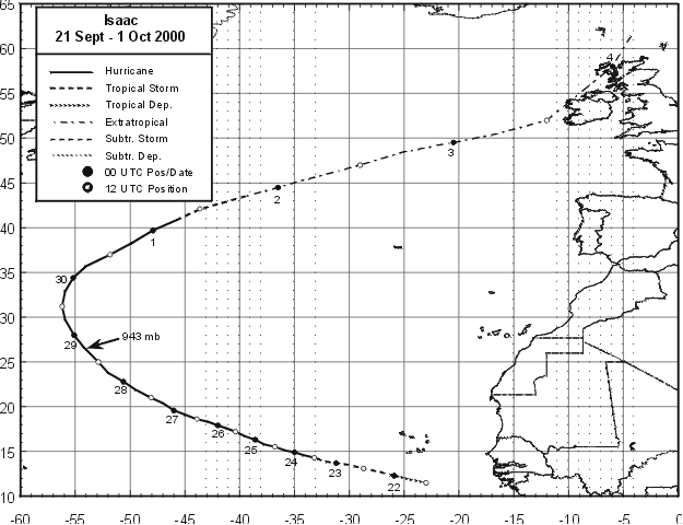
Figure 1.
Best track for Hurricane Isaac, 21 September - 1 October 2000.
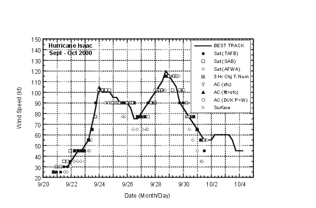
Figure 2.
Best track maximum sustained surface wind speed curve for Hurricane Isaac,
21 September - 1 October 2000, showing the various satellite-based intensity
estimates.
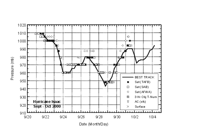
Figure 3.
Best track minimum central pressure curve and satellite-based central
pressure estimates for Hurricane Isaac, 21 September - 1 October 2000.
![[NCEP Logo]](graphics/ncep.gif)


