Tropical Cyclone Report
Hurricane Karl
16 - 24 September 2004
Jack Beven
National Hurricane Center
17 December 2004
Karl was a category 4 hurricane on the
Saffir-Simpson Hurricane Scale that traveled across the open
central North Atlantic.
a. Synoptic History
Karl formed from a strong tropical wave
that moved westward from the coast of Africa on 13 September. The
system showed increasing shower activity on 14 September, and
Dvorak satellite intensity estimates began the next day. The wave
spawned a tropical depression around 0600 UTC 16 September about
340 n mi southwest of the southern Cape Verde islands. The "best
track" chart of the tropical cyclone's path is given in
Figure 1,
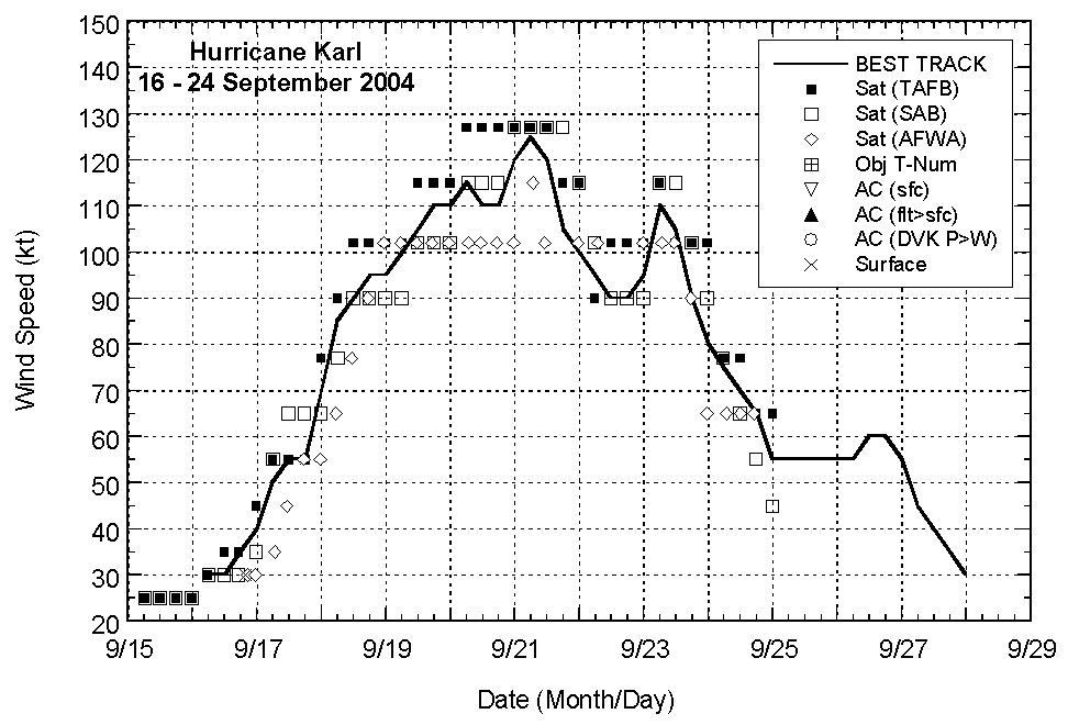
with the wind and pressure histories shown in
Figure 2 and Figure 3,
respectively. The best track positions and intensities are listed
in Table 1.
The depression initially moved westward
south of a subtropical ridge and strengthened into a tropical storm
later that day. Karl turned northwestward on 17 September, then
moved west-northwestward while becoming a hurricane the next day.
The hurricane continued west-northwestward on 19 September, then
turned northwestward on 20 September and north-northwestward on 21
September towards a weakness in the ridge. Maximum sustained winds
reached an estimated 115 kt on 20 September and an estimated 125 kt
on 21 September. Karl continued moving north-northwestward until 22
September when it turned northeastward in response to a deep-layer
baroclinic trough developing north of the hurricane. This motion
continued through 23 September. The intensity fluctuated during
this time due to a concentric eyewall cycle, with maximum sustained
winds decreasing to an estimated 90 kt on 22 September and
increasing to an estimated 110 kt the next day. Karl turned
northward east of the trough on 24 September and weakened as
transition to an extratropical cyclone began. The transition was
complete early on 25 September about 510 n mi east of Cape Race,
Newfoundland.
As an extratropical low, Karl moved
northeastward and eastward across the North Atlantic Ocean and the
North Sea, eventually reaching Norway before being absorbed into
another extratropical low late on 28 September.
b. Meteorological Statistics
Observations in Karl (Figure 2 and Figure 3)
include satellite-based Dvorak technique intensity estimates from
the Tropical Analysis and Forecast Branch (TAFB), the Satellite
Analysis Branch (SAB) and the U. S. Air Force Weather Agency
(AFWA). Microwave satellite imagery from NOAA polar-orbiting
satellites, the NASA Tropical Rainfall Measuring Mission (TRMM),
the NASA QuikSCAT, the NASA Aqua, the Department of Defense
Coriolis/Windsat satellite, and Defense Meteorological Satellite
Program (DMSP) satellites were also useful in tracking Karl.
Shipping avoided the core of Karl, with
reports of winds of tropical storm force from the periphery of the
cyclone given in Table 2. The highest reported wind was from the
Rotterdam, which reported a sustained wind of 45 kt at 1800
UTC 24 September. Two drifting buoys encountered the core of Karl
on 24 September. Buoy 41600 reported a pressure of 958.1 mb at 0100
UTC, while buoy 44617 reported a pressure of 964.2 mb at 2100
UTC.
c. Casualty and Damage Statistics
There were no reports of damages or
casualties associated with Karl.
d. Forecast and Warning Critique
Average official track errors (with the
number of cases in parentheses) for Karl were 37 (31), 65 (29), 84
(27), 101 (25), 118 (21), 125 (17), and 147 (13) n mi for the 12,
24, 36, 48, 72, 96, and 120 h forecasts, respectively. These errors
are lower than the average official track errors for the 10-yr
period 1994-2003[1] (44, 78, 112, 146, 217, 248, and
319 n mi, respectively), (Table 3) - about 20% lower at 12-36 h
increasing to 50-60% lower at 96 and 120 h. Some of the track
forecast models had average errors lower than the official. These
include the GUNA consensus model, which was better at all times
except 12 h, and the GFS global model, which was better at all
times except 12 and 120 h.
Average official intensity errors were 11,
11, 11, 13, 16, 13 and 11 kt for the 12, 24, 36, 48, 72, 96, and
120 h forecasts, respectively. For comparison, the average official
intensity errors over the 10-yr period 1994-2003 are 6, 10, 12, 15,
19, 20, and 21 kt, respectively.
Watches and warnings were not necessary for
Karl.
Acknowledgements
Portions of the track of Karl as an
extratropical low were provided by the Ocean Prediction Center and
the United Kingdom Meteorological Office.
[1]Errors given
for the 96 and 120 h periods are averages over the three-year
period 2001-3.
Table 1: Best track for Hurricane Karl, 16
- 24 September 2004.
Date/Time
(UTC) | Position | Pressure
(mb) | Wind Speed
(kt) | Stage |
Lat.
(°N) | Lon.
(°W) |
| 16 / 0600 | 11.2 | 29.2 | 1008 | 30 | tropical
depression |
| 16 / 1200 | 11.2 | 30.7 | 1007 | 30 | " |
| 16 / 1800 | 11.2 | 32.1 | 1005 | 35 | tropical
storm |
| 17 / 0000 | 11.2 | 33.3 | 1002 | 40 | " |
| 17 / 0600 | 11.6 | 34.4 | 997 | 50 | " |
| 17 / 1200 | 12.1 | 35.3 | 994 | 55 | " |
| 17 / 1800 | 13.0 | 36.0 | 992 | 55 | " |
| 18 / 0000 | 13.9 | 37.0 | 984 | 70 | hurricane |
| 18 / 0600 | 14.5 | 38.0 | 975 | 85 | " |
| 18 / 1200 | 15.0 | 38.8 | 970 | 90 | " |
| 18 / 1800 | 15.6 | 39.7 | 965 | 95 | " |
| 19 / 0000 | 15.9 | 40.8 | 965 | 95 | " |
| 19 / 0600 | 16.0 | 41.6 | 960 | 100 | " |
| 19 / 1200 | 16.3 | 42.4 | 955 | 105 | " |
| 19 / 1800 | 16.7 | 43.4 | 951 | 110 | " |
| 20 / 0000 | 16.8 | 44.5 | 951 | 110 | " |
| 20 / 0600 | 17.0 | 45.2 | 948 | 115 | " |
| 20 / 1200 | 17.5 | 46.0 | 951 | 110 | " |
| 20 / 1800 | 18.1 | 46.5 | 951 | 110 | " |
| 21 / 0000 | 18.7 | 47.0 | 943 | 120 | " |
| 21 / 0600 | 19.6 | 47.3 | 938 | 125 | " |
| 21 / 1200 | 20.8 | 47.8 | 943 | 120 | " |
| 21 / 1800 | 22.3 | 48.3 | 948 | 105 | " |
| 22 / 0000 | 23.7 | 48.8 | 955 | 100 | " |
| 22 / 0600 | 24.9 | 49.4 | 962 | 95 | " |
| 22 / 1200 | 26.2 | 49.5 | 967 | 90 | " |
| 22 / 1800 | 27.5 | 48.7 | 970 | 90 | " |
| 23 / 0000 | 29.0 | 47.7 | 965 | 95 | " |
| 23 / 0600 | 30.7 | 46.3 | 951 | 110 | " |
| 23 / 1200 | 32.5 | 44.4 | 953 | 105 | " |
| 23 / 1800 | 34.5 | 43.0 | 955 | 90 | " |
| 24 / 0000 | 36.8 | 41.9 | 957 | 80 | " |
| 24 / 0600 | 39.5 | 41.2 | 959 | 75 | " |
| 24 / 1200 | 42.6 | 40.5 | 961 | 70 | " |
| 24 / 1800 | 45.5 | 40.5 | 962 | 65 | " |
| 25 / 0000 | 48.1 | 40.5 | 963 | 55 | extratropical |
| 25 / 0600 | 50.4 | 38.9 | 967 | 55 | " |
| 25 / 1200 | 53.0 | 36.5 | 973 | 55 | " |
| 25 / 1800 | 56.1 | 32.0 | 980 | 55 | " |
| 26 / 0000 | 59.5 | 26.0 | 986 | 55 | " |
| 26 / 0600 | 62.0 | 17.0 | 983 | 55 | " |
| 26 / 1200 | 63.5 | 8.0 | 976 | 60 | " |
| 26 / 1800 | 64.0 | 2.0 | 976 | 60 | " |
| 27 / 0000 | 64.0 | 2.5E | 980 | 55 | " |
| 27 / 0600 | 64.5 | 7.0E | 980 | 45 | " |
| 27 / 1200 | 65.0 | 10.5E | 986 | 40 | " |
| 27 / 1800 | 65.3 | 12.0E | 989 | 35 | " |
| 28 / 0000 | 65.5 | 13.5E | 992 | 30 | " |
| 28 / 0600 | | | | | absorbed by
extratropical low |
| 21 / 0600 | 19.6 | 47.3 | 938 | 125 | minimum pressure |
Table 2: Selected ship/drifting buoy
reports with winds of at least 34 kt for Hurricane Karl, 16 -24
September 2004.
| Ship Name or Call Sign | Date/Time (UTC) | Lat.
(°N) | Lon.
(°W) | Wind dir/speed (deg/kt) | Pressure (mb) |
| Bering Sea | 21 / 0600 | 19.5 | 43.8 | 150 / 35 | 1011.0 |
| Buoy 13600 | 21 / 1540 | 22.4 | 46.8 | 230 / 39 | 1000.5 |
| Lapponian
Reefer | 23 / 1200 | 27.6 | 43.1 | 180 / 44 | 1011.7 |
| Star Herdla | 23 / 1500 | 31.0 | 41.4 | 170 / 41 | 1007.0 |
| A8CR8 | 23 / 1800 | 29.5 | 40.7 | 200 / 41 | 1012.0 |
| Star Herdla | 23 / 1800 | 31.1 | 41.5 | 190 / 39 | 1004.7 |
| Maersk
Durban | 24 / 0600 | 36.4 | 36.0 | 230 / 41 | 1009.0 |
| Santa Maria | 24 / 0600 | 42.8 | 38.1 | 120 / 39 | 1002.4 |
| ColomboBay | 24 / 0900 | 42.5 | 46.9 | 010 / 35 | 1003.1 |
| Rotterdam | 24 / 1800 | 44.4 | 34.5 | 150 / 45 | 1009.3 |
|
Table 3: Preliminary forecast evaluation
(heterogeneous sample) for Hurricane Karl, 16 - 24 September 2004.
Forecast errors (n mi) are followed by the number of forecasts in
parentheses. Errors smaller than the NHC official forecast (OFCL)
are shown in bold-face type. Verification includes the depression
stage, but does not include the extratropical stage, if any.
| Forecast Technique | Period (hours) |
| 12 | 24 | 36 | 48 | 72 | 96 | 120 |
| CLP5 | 51 (32) | 111 (30) | 187 (28) | 262 (26) | 390 (22) | 489 (18) | 544 (14) |
| GFDI | 31 (30) | 51 (28) | 62 (26) | 73 (24) | 110 (20) | 153 (16) | 188 (12) |
| GFDL* | 39 (30) | 56 (28) | 64 (26) | 72 (25) | 107 (21) | 147 (17) | 165 (12) |
| GFNI | 49 (29) | 85 (27) | 120 (25) | 161 (23) | 228 (19) | 269 (15) | 294 (11) |
| GFDN* | 49 (30) | 87 (28) | 115 (26) | 148 (24) | 229 (20) | 265 (16) | 255 (12) |
| AF1I | 38 (24) | 62 (22) | 80 (21) | 103 (19) | 120 (15) | | |
| AFW1* | 52 (12) | 85 (12) | 91 (11) | 101 (10) | 116 (8) | | |
| LBAR | 34 (32) | 56 (30) | 78 (28) | 111 (26) | 216 (22) | 272 (18) | 380 (14) |
| A98E | 43 (32) | 80 (30) | 131 (28) | 169 (26) | 304 (22) | 445 (18) | 731 (14) |
| A9UK | 42 (15) | 83 (14) | 126 (13) | 153 (12) | 218 (10) | | |
| BAMD | 43 (32) | 76 (30) | 107 (28) | 139 (26) | 239 (22) | 284 (18) | 382 (14) |
| BAMM | 48 (32) | 84 (30) | 118 (28) | 151 (26) | 222 (22) | 226 (18) | 305 (14) |
| BAMS | 59 (32) | 110 (30) | 155 (28) | 187 (26) | 209 (22) | 167 (18) | 279 (14) |
| NGPI | 50 (31) | 95 (29) | 135 (27) | 169 (25) | 220 (21) | 199 (17) | 199 (13) |
| NGPS* | 51 (32) | 95 (30) | 136 (28) | 171 (26) | 225 (22) | 218 (18) | 196 (14) |
| UKMI | 49 (27) | 82 (25) | 102 (23) | 128 (21) | 199 (17) | 173 (13) | 302 (10) |
| UKM* | 49 (15) | 84 (14) | 113 (13) | 122 (12) | 159 (10) | 169 (8) | 251 (6) |
| GFSI | 36 (30) | 56 (28) | 66 (26) | 76 (24) | 92 (20) | 115 (16) | 217 (12) |
| GFS* | 37 (31) | 59 (29) | 69 (27) | 76 (25) | 97 (21) | 110 (17) | 183 (13) |
| AEMI | 37 (31) | 64 (29) | 83 (27) | 104 (25) | 146 (21) | 150 (17) | 238 (13) |
| AEMN* | 47 (30) | 66 (28) | 84 (27) | 101 (25) | 149 (21) | 154 (17) | 206 (14) |
| GUNS | 41 (27) | 68 (25) | 87 (23) | 104 (21) | 132 (17) | 109 (13) | 153 (10) |
| GUNA | 38 (27) | 60 (25) | 74 (23) | 89 (21) | 117 (17) | 97 (13) | 137 (10) |
| CONU | 37 (30) | 65 (28) | 83 (26) | 102 (24) | 128 (20) | 116 (16) | 140 (12) |
| FSSE* | 37 (27) | 54 (25) | 67 (23) | 82 (21) | 120 (17) | 116 (13) | 168 (10) |
| OFCI | 39 (30) | 65 (28) | 86 (26) | 99 (24) | 131 (20) | 137 (16) | 165 (12) |
| OFCL | 37 (31) | 65 (29) | 84 (27) | 101 (25) | 118 (21) | 125 (17) | 147 (13) |
| NHC Official (1994-2003 mean) | 44 (3172) | 78 (2894) | 112 (2636) | 146 (2368) | 217 (1929) | 248 (421) | 319 (341) |
*Output from these models was
unavailable at forecast time. |
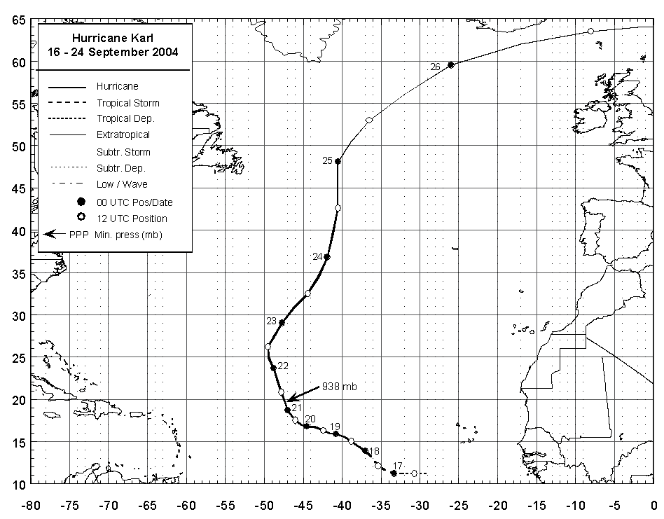
Figure 1:
Best track positions for
Hurricane Karl, 16 - 24 September 2004. Track during the
extratropical stage is based on analyses from the NOAA Ocean
Prediction Center and the United Kingdom Meteorological Office.

Figure 2:
Selected wind observations and
best track maximum sustained surface wind speed curve for Hurricane
Karl, 16 - 24 September 2004. Estimates during the extratropical
stage are based on analyses from the NOAA Ocean Prediction Center
and the United Kingdom Meteorological Office.
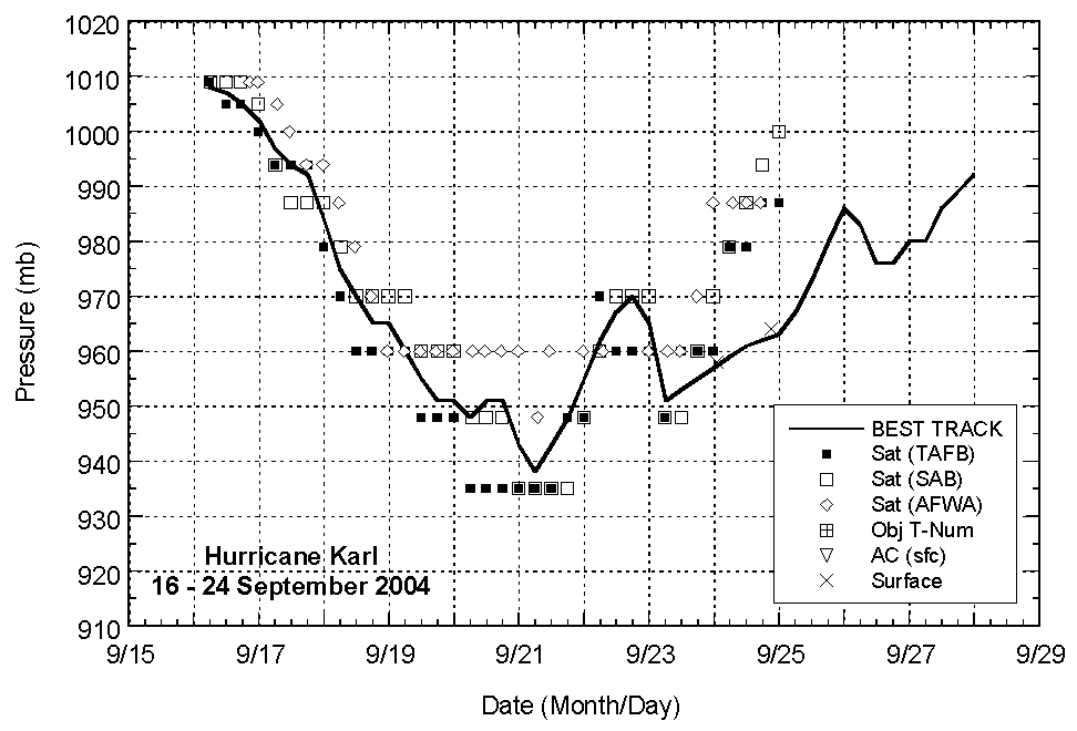
Figure 3:
Selected pressure observations
and best track minimum central pressure curve for Hurricane Karl,
16 - 24 September 2004. Estimates during the extratropical stage
are based on analyses from the NOAA Ocean Prediction Center and the
United Kingdom Meteorological Office.
|