Adrian's center remained well off shore of the Pacific coast of Mexico.
However, outer rain bands associated with the hurricane brought heavy rain
to portions of western Mexico. Six deaths have been attributed to Adrian.
a. Synoptic history
Adrian originated within a large area of disturbed weather associated with a
broad cyclonic turning of low- and mid-level clouds, which persisted for
several days while located to the south of the Gulf of Tehuantepec, Mexico.
The first signs that a tropical cyclone was forming appeared on 16 June,
when a low-level circulation and a banding feature was seen on visible
satellite imagery. This circulation was centered about 175 n mi south of
the Gulf of Tehuantepec. At the same time, a tropical wave which moved
across the coast of Africa on 5 June is estimated to have moved into the
area of the incipient cyclone on the 16th and 17th.
This estimate is based primarily on continuity considerations, as the wave
itself was rather poorly defined except while located over the eastern
tropical Atlantic Ocean.
Adrian became a tropical depression early on the 18th when a
convective band with tops to -85C became more developed. The circulation
center at this time was located about 225 n mi southeast of Acapulco,
Mexico. The best track begins here, as seen on the map showing the track in
Fig. 1. A complete listing of best track six-hour positions, wind speeds,
and central pressures are given in Table 1.
The motion of the cyclone center was generally toward the west-northwest
during its entire existence, roughly parallel to the coast of Mexico, and
175-225 n mi offshore. This steering was, in part, provided by a
deep-layer-mean ridge of high pressure located over Mexico. The forward
motion accelerated 10 kt on the 18th and to 14 kt on the
19th. It then decelerated down to about 2 kt on the
22nd, as the cyclone approached the western periphery of the
ridge to the north and weaker steering currents.
Adrian became a tropical storm late on the 18th, as easterly
vertical shear relaxed and an outflow pattern developed aloft. A central
dense overcast formed on the 19th and Adrian became a hurricane on
the 20th, while centered about 420 n mi south-southeast of the
southern tip of Baja Californina. Maximum 1-min surface wind speeds of 85 kt
were estimated late on the 19th and early on the 20th,
as an eye formed briefly on satellite imagery. Then, southeasterly shear
and increasingly cooler SST's resulted in a weakening trend. This system was
reduced to a of low clouds on the 22nd, while centered about 300
n mi southwest of the southern tip of Baja California.
b. Meteorological statistics
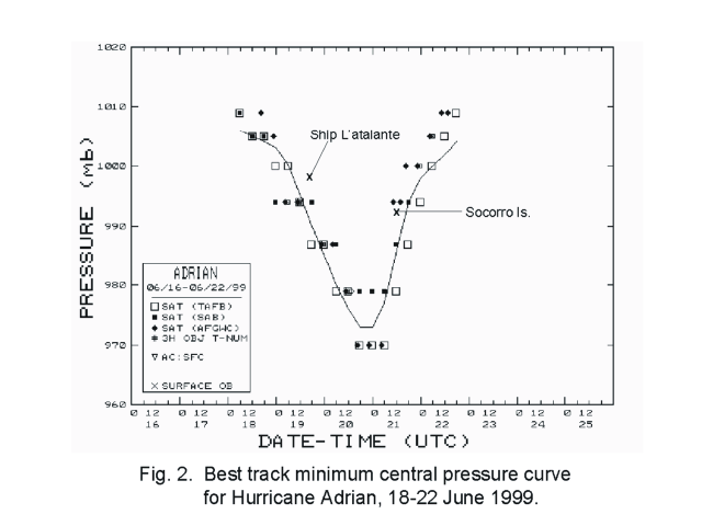
Figures 2 and 3, respectively, show best track curves of wind speed and
central pressure versus time. The satellite Dvorak estimates of wind and
pressure that were used to determine the best track values are plotted on
these figures. In addition, the ship L'atalante, moving southward
from Mexico, passed about 30 n mi west of the center of Adrian on the
19th, as the storm was reaching hurricane force. The ship's
minimum pressure was 998.6 mb and its reported maximum wind was only 34 kt,
indicating that the winds were probably weaker on the west side of the
circulation.
The center of Adrian also passed about 30 n mi south of Socorro Island on the
21st, while weakening from a hurricane to a tropical storm.
Reports are incomplete from this island. However, a 993 mb surface pressure
was reported at 1200 UTC when the center was near its point of closest
approach. Socorro Island's surface wind observation at this time was 070
degrees at 39 kt and this was the highest wind speed reported from there.
c. Casualty and damage statistics
Some of Adrian's outer rain bands produced heavy rain over portions of
Mexico. According to the Associated Press, the Mexican government news
agency Notimex reported minor flooding in the northern state of Coahuila and
the coastal state of Colima. Reuters reported two drowning deaths and one
person missing inland in the state of Chiapas from river flooding. Although
Adrian's winds were only in the 30 to 40 kt range on the 18th,
Reuters reported that four persons were swept away and drowned from a huge
wave on the beach in Chiapas.
d. Forecast and warning critique
The official track forecast errors were generally in the normal range for
the eastern Pacific basin, ranging from 11 n mi at the 0-hr forecast to 83 n
mi at 24 hours to 148 n mi at 48 hours to 149 n mi at 72 hours. The number
of cases ranged from 15 at the 0-hour to 3 cases at 72 hours. During the
18th and 19th, the GFDL model exhibited a right bias
showing a threat to Mexico. This is believed to be related to poor
initializations of the NCEP global spectral model and the official forecasts
were not influenced by this bias. Official wind speed forecast errors were
generally small. In the early stages, the official forecast had a negative
bias, under-forecasting the peak intensity by 20 kt. Conversely, in the
weakening stages, the official forecasts were too slow to weaken the storm,
with one 30-kt over-forecast at 36 hours.
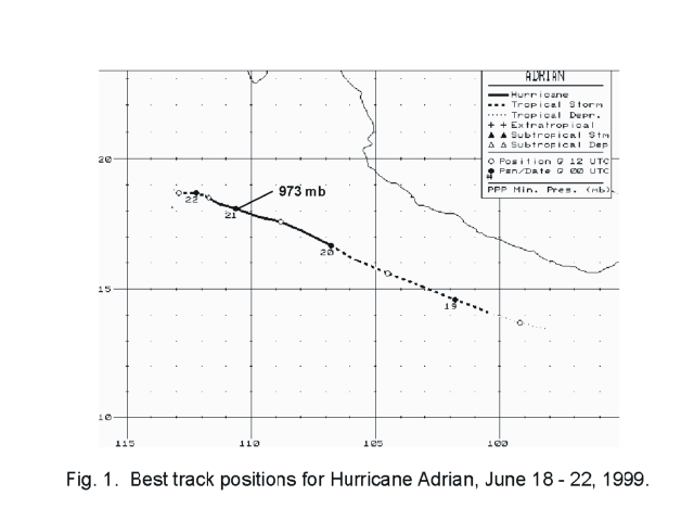
Figure 1.
Best track positions for Hurricane Adrian, 18-22 June 1999.

Figure 2.
Best track minimum central pressure curve for Hurricane Adrian, 18-22 June
1999.

Figure 3.
Best track one-minute surface wind speed curve for Hurricane Adrian, 18-22
June 1999.
Table 1.
Preliminary Best Track - Hurricane Adrian, 18-22 June 1999.
Date/Time
(UTC) |
Position |
Pressure
(mb) |
Wind Speed
(kt) |
Stage |
| Lat. (°N) |
Lon. (°W) |
| 18/0600 | 13.5 | 98.2 | 1006 | 30 | tropical depression |
| 1200 | 13.7 | 99.2 | 1005 | 30 | " |
| 1800 | 14.1 | 100.4 | 1004 | 35 | tropical storm |
| 19/0000 | 14.6 | 101.8 | 1003 | 40 | " |
| 0600 | 15.1 | 103.1 | 1000 | 50 | " |
| 1200 | 15.6 | 104.5 | 995 | 55 | " |
| 1800 | 16.1 | 105.7 | 990 | 60 | " |
| 20/0000 | 16.7 | 106.8 | 985 | 65 | hurricane |
| 0600 | 17.2 | 107.8 | 980 | 70 | " |
| 1200 | 17.6 | 108.8 | 976 | 75 | " |
| 1800 | 17.8 | 109.7 | 973 | 85 | " |
| 21/0000 | 18.1 | 110.6 | 973 | 85 | " |
| 0600 | 18.3 | 111.3 | 977 | 80 | " |
| 1200 | 18.5 | 111.7 | 986 | 70 | " |
| 1800 | 18.6 | 111.9 | 994 | 60 | tropical storm |
| 22/0000 | 18.7 | 112.2 | 998 | 45 | " |
| 0600 | 18.7 | 112.6 | 1000 | 35 | " |
| 1200 | 18.7 | 112.9 | 1002 | 30 | tropical depression |
| 1800 | 18.8 | 113.1 | 1004 | 25 | " |
| | | | | |
| |
| 21/0000 | 18.1 | 110.6 | 973 | 85 | minimum pressure |
![[NCEP Logo]](graphics/ncep.gif)