Jerry spread heavy rains over portions of the southeastern
United States.
a. Synoptic History
Satellite images indicate that an area of cloudiness, associated with a
tropical wave that left
western Africa on 9 August, propagated westward across the tropical Atlantic from the
9th to the 15th of August. Even though convection increased when
the wave neared the Lesser Antilles on the 15th, there were no
large surface pressure falls noted in those islands. When the wave
moved over the eastern and central Caribbean Sea, rawinsonde data
from San Juan and Santo Domingo revealed that the system was fairly
strong at mid- to lower-tropospheric levels, as evidenced by 30- to
40-knot wind reports east of the wave axis at 850 and 700 mb.
By the 19th, satellite pictures and surface data gave some
evidence of a low-level circulation centered near 18N 75W at 1200 UTC.
No further development occurred during the next couple of
days as the system moved west-northwestward to northwestward,
interacting with the mountainous land mass of eastern Cuba. On the
22nd, cloudiness and convection became better organized near the
western Bahamas, and surface reports indicate that a
tropical
depression formed from this system a short distance southwest of
Andros Island at 1800 UTC 22 August (as shown in the post-analysis
best track in Table 1
and Fig. 1 [49K GIF]).
Upper-level winds were partially favorable for development, since anticylonic outflow
prevailed over the eastern half of the depression while outflow was
inhibited to the west and northwest.
As the depression moved north-northwestward toward southeast
Florida, slow strengthening took place. Based on measurements from
a NOAA plane,
it is estimated that the system strengthened to a
tropical storm
around 1200 UTC on the 23rd. Tropical Storm Jerry made landfall later
that same day near Jupiter, Florida as a 35-knot storm. Jerry moved
northwest to west-northwest across the Florida peninsula, weakening
back to a tropical depression by 1800 UTC on the 24th while nearing
the upper west coast of Florida. The forward motion slowed, and after
the center
drifted a short distance out over the waters of the Gulf
of Mexico, Jerry turned toward the north and moved inland again over
northern Florida and across the Georgia/Florida border on 25 August.
The weak depression moved slowly northward to north-northwestward
over Georgia on the 26th and 27th. Later on the
27th, Jerry turned eastward toward South Carolina. By 0000 UTC on
the 28th, the circulation of Jerry became elongated in a northeast-southwest
oriented trough, and six hours later it was impossible
to distinguish a circulation center. However, the trough persisted
near the Carolinas during the next couple of days and two discrete
low pressure centers appeared. The first moved eastward from the
coast of North Carolina into the Atlantic without significant
development. The second became evident just offshore of the
Georgia/South Carolina border early on the 29th. This weak surface
low moved southward and southwestward, across the Florida peninsula
on 30-31 August, and died a slow death over the southeast Gulf of
Mexico during the first few days of September. There was, and
still is, confusion concerning which, if any, of these two lows was
derived from the original circulation of Jerry.
b. Meteorological Statistics
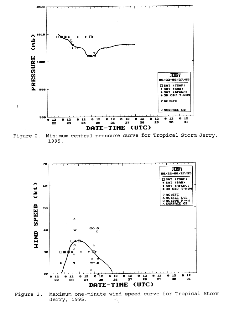
The post-analysis best track intensities for Jerry are listed
in Table 1 and displayed in
Figs. 2 and 3 (52K GIF),
which show the estimated minimum central pressure and maximum one-minute wind speed,
respectively, versus time. These intensity estimates were derived
from analyses of satellite images, using the
Dvorak technique,
performed by meteorologists at the
Synoptic Analysis Branch (SAB)
and the Tropical Analysis and Forecast Branch
(TAFB; formerly the Tropical Satellite Analysis and Forecast unit, TSAF, as in the
figures) and at the
Air Force Global Weather Central (AFGWC), along
with aerial reconnaissance data and surface observations.
The highest flight-level wind measurement from aerial
reconnaissance of Jerry was 45 knots at an altitude of 1500 feet,
taken from a NOAA plane at 1621 UTC
23 August. Sustained winds of 35 knots and a gust to 43 knots were observed
at Lake Worth Inlet, Florida (close to the landfall point) at 2100 UTC 23 August.
Patrick Air Force Base
reported sustained winds of 37 knots gusting to 50 knots at 0640 UTC 24 August.
Sustained winds of 37 knots with a gust to 55 knots, at an elevation of 54 feet
above ground level, were recorded at Cape Canaveral at 1420 UTC 24 August.
The only known ship report of tropical storm force winds
associated with Jerry was from the vessel Atlantic Erie: winds
120/34 knots, and pressure 1012.0 mb, at 28.7°N 78.4°W on 0600 UTC
24 August. This was about 155 n mi to the east-northeast of the storm center.
A waterspout was observed over Tampa Bay east of the St.
Petersburg Pier at 1840 UTC on the 23rd. A small, brief tornado
was observed 10 n mi west of Zephyrhills in Pasco County, FL at
1647 UTC on the 24th. No damage was reported. Another, presumably
minor, tornado was observed 6 n mi west of Ruskin in Hillsborough
County, FL at 1547 UTC on the 25th.
Jerry caused very heavy rainfall over Florida, Georgia, South
Carolina and North Carolina. Rainfall totals of up to 10 to 15
inches were reported over the southwest and west-central coastal
sections of Florida from the Naples/Ft. Myers area northward to
Tampa, with one total of 16.80 inches at Golden Gate (east of
Naples). Rainfall totals over southeast Florida were generally 3
to 8 inches, although locally heavier rainfall in the 9 to 10 inch
range occurred in Martin and St. Lucie counties. Rainfall amounts
of at least 8 inches occurred over eastern Georgia. Rainfall
totals exceeded 12 inches over portions of western South Carolina.
Rainfall amounts reached 8 to 9 inches over parts of North
Carolina, with local totals of 15 to 17 inches over portions of
north-central North Carolina.
Storm tides were generally
1 to 2 feet above normal along the southeast and central east coast of Florida,
and 1 to 1.5 feet above normal along the west coast of Florida, due to Jerry.
c. Casualty and Damage Statistics
Flooding caused three deaths in South Carolina and three
deaths in North Carolina.
In Florida, freshwater flooding near the west coast was
responsible for most of the damage from Jerry. Three-hundred forty
buildings were damaged in Collier County, Florida, with 12
uninhabitable. Flooding was particularly severe in Lee and
Charlotte counties. Property damage in Florida totalled $1.5
million and damage to agriculture was estimated to be $19 million.
Damage figures due to flooding over the remainder of the southeast
U.S. are incomplete. The governor of North Carolina estimated $6
million in uninsured losses in the Raleigh area. This makes a
total damage estimate for Jerry of $26.5 million, although
additional (unknown) flood damage likely took place in Georgia and South Carolina.
d. Forecast and Warning Critique
Jerry was a tropical storm for only 24 hours, so there are no
relevant forecast error statistics for this system. During the
initial depression stage, the NHC advisories did not predict the
cyclone to strengthen to a tropical storm. When Jerry
did become a minimal storm, nearing the coast of southeast Florida, even
though a tropical storm warning
was posted for the east coast from
Flagler Beach southward to Deerfield Beach, the advisories
emphasized that the primary concern was heavy rainfall.
Table 2 gives a chronology of the watches
and warnings for Jerry. The day after the storm made landfall (the 24th) a tropical
storm warning was issued for the Gulf coast of Florida from the
Anclote Keys to Pensacola, since Jerry was expected to emerge over
the Gulf and to restrengthen. The latter tropical storm warning
turned out to be unnecessary, since Tropical Depression Jerry soon
moved back inland over north Florida without redevelopment. All
warnings were discontinued at 1500 UTC 25 August.
![[NCEP Logo]](graphics/ncep.gif)
