|
|
 |
Digital Earth Workbench: Multiple Views of the Florida Keys
|
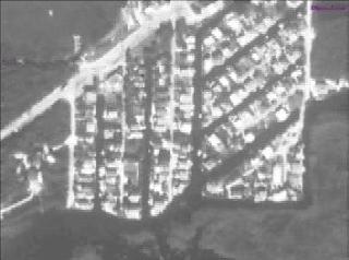
The Digital Earth Workbench is an interactive application that runs on a SGI Onyx Infinite Reality system and is controlled by an Immersive Workbench, tracked stereo glasses, and a tracked wand. The application allows an unprecedented freedom to roam georeferenced data sets at multiple resolutions and timescales. This animation is one of a series of direct screen captures of the application in operation. The occasional menu appearance denotes direct intervention by the operator to add or delete data or to activate a new control option.
|
|
|
|
Zooming from the east coast of North America to the Florida Keys, adding first a Landsat image, then an aerial photograph, and then a benthic habitat map, before zooming back out to a continental view.
Duration: 55.0 seconds
Available formats:
352x240 (29.97 fps)
MPEG-1
7 MB
160x80
PNG
17 KB
80x40
PNG
6 KB
320x238
JPEG
14 KB
How to play our movies
|
| Animation Number: | 796 |
| Animator: | Steve Maher (Lead) |
| Studio: | NASA |
| Completed: | 1999-11-12 |
| Scientist: | Gene Feldman (NASA/GSFC) |
| Instrument: | Landsat |
| Data Collected: | Various |
| Series: | Digital Earth Workbench |
| Video: | SVS1999-0031 * |
Keywords:
DLESE
>> Biological oceanography
SVS
>> Florida Keys
DLESE
>> Human geography
DLESE
>> Physical geography
DLESE
>> Technology
|
|
Please give credit for this item to
NASA/Goddard Space Flight Center
Scientific Visualization Studio |
*Please note: the SVS does not fulfill requests for copies of the tapes in our library. On some of our animation pages, there is a direct link to a video distribution service from which tapes, handled by the Public Affairs Office (PAO)/Goddard TV, including some of our animations may be ordered. General information on this service can be found here. |
|
Back to Top
|
|
|
|

