|
|
 |
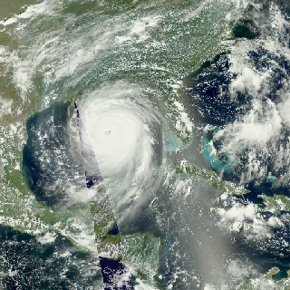
Aqua MODIS Imagery of Hurricane Katrina (WMS)
|
Low earth-orbiting satellites, such as Aqua, usually see any place on Earth no more than once a day. This daily sequence of color images from the MODIS instrument on Aqua shows the Gulf of Mexico during the period of Hurricane Katrina, from August 23 to August 30, 2005. The gaps in the MODIS imagery occur between successive orbits, about 90 minutes apart, and are filled in in this animation using high-resolution visible imagery from GOES-12.
|
|
|
|
Imagery of Hurricane Katrina from August 23, 2005 to August 30, 2005 from the MODIS Instrument on the Aqua satellite. Gaps in the MODIS imagery have been filled in with visible imagery from GOES-12.
Duration: 4.0 seconds
Available formats:
512x512 (29.97 fps)
MPEG-1
1 MB
320x320
PNG
247 KB
160x80
PNG
29 KB
80x40
PNG
7 KB
1024x1024
Frames
How to play our movies
|
|
This product is available through our Web Map Service.
Click here to learn more.
|
|
|
Back to Top
|
|
|
|


