Skip all navigation and jump to content Jump to site navigation Jump to section navigation.
NASA Logo - Goddard Space Flight Center + Visit NASA.gov
HOME PROJECTS RESOURCES SEARCH MAP

+ Advanced Search
Home
Home
View Most Recently Released Imagery
View Gallery of Imagery: A topical collection of SVS Imagery
Search Imagery by the keywords assigned to it
Search Imagery by the instruments that supplied data for a visualization product
Search Imagery by the series of visualizations that have been produced
Search Imagery by the scientist providing the data used in a visualization product
Search Imagery by the animator that created the product
Search Imagery by the identification number assigned to the visualization product
See other search options
Learn about the SVS Image Server
  + About the Server
  + Animation List
  + How to Use the Server


  + RSS Feeds
blank image
Previous Animation
Next Animation
Before and During the Great Mississippi Flood of 1993

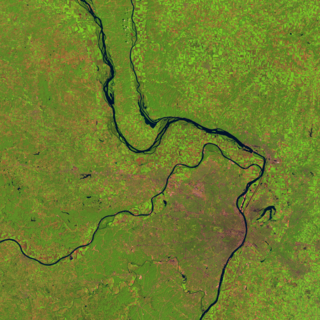
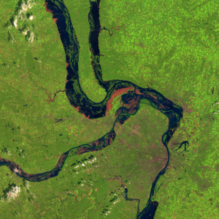
During the first half of 1993, heavy rains in the Midwest United States caused the greatest flood ever recorded on the Upper Mississippi. The Mississippi River remained above flood stage from April through September of that year, and many of the dykes and water control systems along the rivers in this region were overwhelmed. These images from the Landsat-5 Thematic Mapper clearly show the flooded regions near St. Louis. The pink areas near the flooded regions show the scoured land from which the flood waters have receded. A comparison of the image during the flood with an image from a year before clearly shows the preponderance of cultivated fields in the lowland flooded region, evidence that floods and river meanderings have deposited rich soil in these regions in the past.

This animation shows two images from Landsat-5 of the region around St. Louis, Missouri, one from 1991 during normal conditions and one during the flood of 1993.    This animation shows two images from Landsat-5 of the region around St. Louis, Missouri, one from 1991 during normal conditions and one during the flood of 1993.
Duration: 4.0 seconds
Available formats:
  2048x2048 Frames
  320x320     PNG           223 KB
  160x80       PNG           31 KB
  80x40         PNG           10 KB
  512x512 (29.97 fps) MPEG-1   1 MB
  512x512 (29.97 fps) MPEG-4   1 MB
How to play our movies

This product is available through our Web Map Service.   Click here to learn more.

An image from the Landsat-5 Thematic Mapper of the region around St. Louis, Missouri, on August 14, 1991, one year before the Mississippi flood.  The three rivers seen in this image are, from top to bottom, the Illinois, the Mississippi, and the Missouri.  St. Louis is just south of the Missouri River in the center of this image.    An image from the Landsat-5 Thematic Mapper of the region around St. Louis, Missouri, on August 14, 1991, one year before the Mississippi flood. The three rivers seen in this image are, from top to bottom, the Illinois, the Mississippi, and the Missouri. St. Louis is just south of the Missouri River in the center of this image.

Available formats:
  3390 x 3390     PNG 19 MB
  320 x 320         PNG 220 KB
  160 x 80           PNG 25 KB

This product is available through our Web Map Service.   Click here to learn more.

An image from the Landsat-5 Thematic Mapper of the region around St. Louis Missouri on August 19, 1993, just after the peak of the Mississippi flood.    An image from the Landsat-5 Thematic Mapper of the region around St. Louis Missouri on August 19, 1993, just after the peak of the Mississippi flood.

Available formats:
  3390 x 3390     PNG 19 MB
  320 x 320         PNG 220 KB
  160 x 80           PNG 25 KB

This product is available through our Web Map Service.   Click here to learn more.
Animation Number:3352
Animator:Horace Mitchell (SVS) (Lead)
Completed:2006-04-04
Scientist:Darrel Williams (NASA/GSFC)
Instrument:Landsat-5/TM
Data set:Landsat-5 Band Combination 5, 4, 2
Data Collected:1991/08/14, 1993/08/19
Series:WMS
Keywords:
DLESE >> Human geography
DLESE >> Hydrology
DLESE >> Natural hazards
GCMD >> EARTH SCIENCE >> Human Dimensions >> Natural Hazards >> Hydrological Hazards
GCMD >> EARTH SCIENCE >> Hydrosphere >> Surface Water >> Floods
GCMD >> EARTH SCIENCE >> Hydrosphere >> Surface Water >> Rivers/Streams
More Information on this topic available at:
http://earthobservatory.nasa.gov/Newsroom/NewImages/images.php3?img_id=16881
View Animation in Google Earth Google Earth KML file is available here.
DEPC Metadata is available here.
 
 
Please give credit for this item to
NASA/Goddard Space Flight Center Scientific Visualization Studio


Back to Top

USA.gov logo - the U.S. Government's official Web portal. + Privacy Policy and Important Notices
+ Reproduction Guidelines
NASA NASA Official:
SVS Contact:
Curator: