06344600: Flow=0.00cfs,Stage=5.28ft,2007-10-19 12:30,Low,GREEN RIVER NR NEW HRADEC, ND 06331000, LITTLE MUDDY RIVER BL COW CREEK NR WILLISTON, ND 06345500, HEART RIVER NR RICHARDTON, ND 06339100, KNIFE RIVER AT MANNING, ND 06332515, BEAR DEN CREEK NR MANDAREE, ND 05090000, PARK RIVER AT GRAFTON, ND 05085000, FOREST RIVER AT MINTO, ND 05084000, FOREST RIVER NR FORDVILLE, ND 05060500, RUSH RIVER AT AMENIA, ND 05059000, SHEYENNE RIVER NEAR KINDRED, ND 05058700, SHEYENNE RIVER AT LISBON, ND 05058000, SHEYENNE RIVER BELOW BALDHILL DAM, ND 06349000, HEART RIVER NR MANDAN, ND 06471200, MAPLE R AT ND-SD STATE LINE 06470800, BEAR CREEK NR OAKES, ND 06470500, JAMES RIVER AT LAMOURE, ND 06470000, JAMES RIVER AT JAMESTOWN, ND 05100000, PEMBINA RIVER AT NECHE, ND 05099400, LITTLE SOUTH PEMBINA RIVER NR WALHALLA, ND 05059700, MAPLE RIVER NR ENDERLIN, ND 05057200, BALDHILL CREEK NR DAZEY, ND 05050000, BOIS DE SIOUX RIVER NEAR WHITE ROCK, SD 06342500, MISSOURI RIVER AT BISMARCK, ND 06340500, KNIFE RIVER AT HAZEN, ND 06337000, LITTLE MISSOURI RIVER NR WATFORD CITY, ND 06329500, Yellowstone River near Sidney MT 05120000, SOURIS RIVER NR VERENDRYE, ND 05117500, SOURIS RIVER ABOVE MINOT, ND 05116000, SOURIS RIVER NR FOXHOLM, ND 05054500, SHEYENNE RIVER ABOVE HARVEY, ND 06468170, JAMES RIVER NR GRACE CITY, ND 06354000, CANNONBALL RIVER AT BREIEN, ND 06352000, CEDAR CREEK NR HAYNES, ND 06342260, SQUARE BUTTE CREEK BELOW CENTER, ND 06336000, LITTLE MISSOURI RIVER AT MEDORA, ND 05124000, SOURIS RIVER NR WESTHOPE, ND 05116500, DES LACS RIVER AT FOXHOLM, ND 05114000, SOURIS RIVER NR SHERWOOD, ND 05113600, LONG CREEK NR NOONAN, ND 05099600, PEMBINA RIVER AT WALHALLA, ND 05092000, RED RIVER OF THE NORTH AT DRAYTON, ND 05082500, RED RIVER OF THE NORTH AT GRAND FORKS, ND 05069000, SAND HILL RIVER AT CLIMAX, MN 05064500, RED RIVER OF THE NORTH AT HALSTAD, MN 05064000, WILD RICE RIVER AT HENDRUM, MN 05062000, BUFFALO RIVER NEAR DILWORTH, MN 05057000, SHEYENNE RIVER NR COOPERSTOWN, ND 05056000, SHEYENNE RIVER NR WARWICK, ND 05054000, RED RIVER OF THE NORTH AT FARGO, ND 05051500, RED RIVER OF THE NORTH AT WAHPETON, ND 06470878, JAMES RIVER AT ND-SD STATE LINE 06470875, DAKOTA LAKE NR LUDDEN, ND 06469400, PIPESTEM CREEK NR PINGREE, ND 06468250, JAMES RIVER ABOVE ARROWWOOD LAKE NR KENSAL, ND 06354580, BEAVER CREEK BL LINTON, ND 06353000, CEDAR CREEK NR RALEIGH, ND 06351200, CANNONBALL RIVER NR RALEIGH, ND 06350000, CANNONBALL RIVER AT REGENT, ND 06349700, MISSOURI RIVER NR SCHMIDT, ND 06349600, HAY CREEK AT MAIN AVENUE IN BISMARCK, ND 06349500, APPLE CREEK NR MENOKEN, ND 06348500, SWEETBRIAR CREEK NR JUDSON, ND 06348300, HEART RIVER AT STARK BRIDGE NR JUDSON, ND 06347500, BIG MUDDY CREEK NEAR ALMONT, ND 06347000, ANTELOPE CREEK NR CARSON, ND 06345780, HEART R AB LAKE TSCHIDA NR GLEN ULLIN, ND 06342450, BURNT CREEK NR BISMARCK, ND 06342020, MISSOURI RIVER AT PRICE, ND 06341000, MISSOURI RIVER AT WASHBURN, ND 06340700, MISSOURI RIVER NEAR STANTON, ND 06340000, SPRING CREEK AT ZAP, ND 06339500, KNIFE RIVER NR GOLDEN VALLEY, ND 06336600, BEAVER CREEK NR TROTTERS, ND 06335500, LITTLE MISSOURI RIVER AT MARMARTH, ND 06332770, DEEPWATER CREEK AT MOUTH NR RAUB, ND 06332523, E. FORK SHELL CREEK NR PARSHALL, ND 06330000, MISSOURI RIVER NR WILLISTON, ND 06329610, YELLOWSTONE R NO. 2 NR CARTWRIGHT, ND 06329597, CHARBONNEAU CREEK NR CHARBONNEAU, ND 05123510: 2007-10-19 07:15,Not ranked,Seasonal site,DEEP RIVER NR UPHAM, ND 05123400, WILLOW CREEK NR WILLOW CITY, ND 05122000, SOURIS RIVER NR BANTRY, ND 05121001, SOURIS RIVER EAST OUTFALL AT EATON DAM NR TOWNER 05121000, SOURIS RIVER WEST OUTFALL AT EATON DAM NR TOWNER 05120500, WINTERING RIVER NR KARLSRUHE, ND 05113750, EAST BRANCH SHORT CREEK RES NR COLUMBUS, ND 05102490, RED RIVER OF THE NORTH AT PEMBINA, ND 05101000, TONGUE RIVER AT AKRA, ND 05083500, RED RIVER OF THE NORTH AT OSLO, MN 05082625, TURTLE RIVER AT TURTLE R STATE PARK NR ARVILLA, ND 05070000, RED RIVER OF THE NORTH NEAR THOMPSON, ND 05067500, MARSH RIVER NEAR SHELLY, MN 05066500, GOOSE RIVER AT HILLSBORO, ND 05060400, SHEYENNE RIVER AT HARWOOD, ND 05060100, MAPLE RIVER BL MAPLETON, ND 05060000, MAPLE RIVER NR MAPLETON, ND 05059715, MAPLE RIVER ABOVE MAPLE RIVER DAM NR SHELDON, ND 05059600, MAPLE RIVER NR HOPE, ND 05059500, SHEYENNE RIVER AT WEST FARGO, ND 05059480, SHEYENNE RIVER DIVERSION AT WEST FARGO, ND 05059310, SHEYENNE RIVER DIVERSION NR HORACE, ND 05059300, SHEYENNE R AB SHEYENNE R DIVERSION NR HORACE, ND 05058500, SHEYENNE RIVER AT VALLEY CITY, ND 05056665, EASTERN STUMP LAKE NR LAKOTA, ND 05056636, DEVILS LAKE OUTLET TO STUMP LAKE NR LAKOTA, ND 05056500, DEVILS LAKE NR DEVILS LAKE, ND 05056340, LITTLE COULEE NR LEEDS, ND 05056255, LAKE ALICE-IRVINE CHANNEL NR CHURCHS FERRY, ND 05056241, DRY LAKE NEAR PENN, ND 05056239, STARKWEATHER COULEE NR WEBSTER, ND 05056222M ORRISON LAKE NEAR WEBSTER, ND 05056215, EDMORE COULEE TRIB NR WEBSTER, ND 05056200, EDMORE COULEE NR EDMORE, ND 05056100, MAUVAIS COULEE NR CANDO, ND 05056060, MAUVAIS COULEE TRIB NO. 3 NR CANDO, ND 05055400, SHEYENNE R BL DEVILS LK STATE OUTLET NR BREMEN, ND 05055300, SHEYENNE R AB DEVILS LK STATE OUTLET NR FLORA, ND 05053000, WILD RICE RIVER NR ABERCROMBIE, ND 05052500, ANTELOPE CREEK AT DWIGHT, ND 05051600, WILD RICE RIVER NR RUTLAND, ND 05051522, RED RIVER OF THE NORTH AT HICKSON, ND 05051300, BOIS DE SIOUX RIVER NEAR DORAN, MN 05049995, MUD LAKE ABOVE WHITE ROCK DAM NEAR WHITE ROCK, SD 05046475, OTTERTAIL RIVER DIVERSION AT BRECKENRIDGE, MN
USGS - science for a changing world

North Dakota Water Science Center

home home information/data information/data publications publications FAQs FAQs links links about us about us contact contact internal internal

USGS North Dakota Water Science Centers


USGS IN YOUR STATE


USGS Water Science Centers are located in each state.

There is a USGS Water Science Center office in each State. Washington Oregon California Idaho Nevada Montana Wyoming Utah Colorado Arizona New Mexico North Dakota South Dakota Nebraska Kansas Oklahoma Texas Minnesota Iowa Missouri Arkansas Louisiana Wisconsin Illinois Mississippi Michigan Indiana Ohio Kentucky Tennessee Alabama Pennsylvania West Virginia Georgia Florida Caribbean Alaska Hawaii New York Vermont New Hampshire Maine Massachusettes South Carolina North Carolina Rhode Island Virginia Connecticut New Jersey Maryland-Delaware-D.C.

Hydrologic Data

Hydrologic Conditions for North Dakota

Annual Water-Data Reports

Water-resources data for North Dakota consists of records of discharge, stage, and water quality for streams; contents, stage, and water quality for lakes and reservoirs; and water levels and water quality for ground-water wells.

Beginning with water year 2006, the Annual Water-Data Report has been changed to an online only system that makes surface-water, ground-water, and water-quality data available for the United States from one location. The new user interface allows users to search for data by state and county, hydrologic unit, and site number. There is also a map-based tool for locating hydrologic data. Click on the "Mapper" link to use the map tool.

A water year is the 12-month period October 1 through September 30. The water year is designated by the calendar year in which it ends and which includes 9 of the 12 months. Thus, the year ending September 30, 2005, is called the 2005 water year.


Hydrologic Conditions for the Nation

  • NWISWeb Real-Time Data
    Includes Surface Water - Ground Water - Water Quality
  • NWISWeb Tutorial
    This tutorial includes step-by-step guides for the first-time user of the USGS National Water Information System Web site (NWISWeb).
  • NWISWeb Fact Sheet
    A short description of the features and benefits of NWISWeb.
  • Water Use
    The U.S. Geological Survey's National Water-Use Information Program is responsible for compiling and disseminating the nation's water-use data.
  • Drought Watch
    States where average streamflow was below normal during the previous 7 days
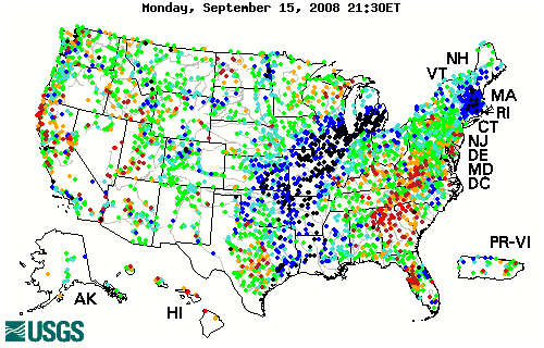
  • Water Watch
    The flood and high flow map shows the location of streamgages in the United States where the water level is currently at or above flood stage or at high flow.


Current Streamflow Conditions
Current North Dakota Streamflow Conditions
Map color code explanation - click for further explanation


Map of Flood and High Flow Conditions
Map of flood and high flow conditions (North Dakota)

Explanation - Percentile Classes

color code for 95th-98th percentile color code for river greater than or equal to 99th percentile color code for river above flood stage Not ranked

95 - 98

> 99

River above flood stage

Not ranked


Map of Below Normal 7-Day Average Streamflow
Map of below normal 7-day average streamflow compared to historical streamflow for the week of the year (North Dakota)

Explanation - Percentile Classes

color code for streamflow in the 10-24th percentile color code for flow at 6-9th percentile color code for flow at or below 5th percentile color code for lowest 7-day flow Not ranked

Below Normal

Moderate Hydrologic Drought

Severe Hydrologic Drought

Extreme Hydrologic Drought

Not Ranked

10th-24th
percentile

6th-9th
percentile

< 5th
percentile

New low


Current Streamflow Conditions for the Nation
Current Streamflow Conditions for the United States
Map color code explanation - click for further explanation


Accessibility FOIA Privacy Policies and Notices

Take Pride in America logo USA.gov logo U.S. Department of the Interior | U.S. Geological Survey
URL: http://nd.water.usgs.gov/data/index.html
Page Contact Information: Webmaster
Page Last Modified: Tuesday, 08-Jul-2008 10:56:07 EDT