Skip Navigation Linkweather.gov 
NOAA logo - Click to go to the NOAA homepage National Weather Service   NWS logo - Click to go to the NWS homepage
Arkansas-Red Basin River Forecast Center


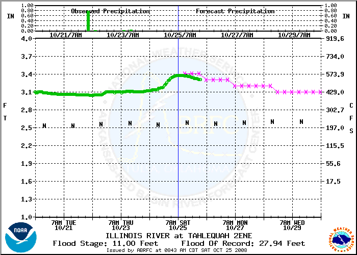
Tahlequah 2ENE (TALO2)
ILLINOIS RIVER

Latest stage: 3.32 ft @ Oct 26 02:00am CST (Note: may not be represented on the hydrograph below.)
Maximum Forecast Stage: 3.40 ft @ Oct 25 1:00pm CST
Tahlequah 2ENE Hydrograph
Legend

:ILLINOIS RIVER NEAR TAHLEQUAH OK
:FLOOD STAGE  11.0  
:
:LATEST STAGE     3.39 FT AT 800 AM CDT ON 1025
.ER TALO2    1025 C DC200810250843/DH13/HGIFF/DIH6
:QPF FORECAST        7AM        1PM        7PM        1AM
.E1 :1025:              /       3.4/       3.4/       3.4
.E2 :1026:   /       3.3/       3.3/       3.3/       3.3
.E3 :1027:   /       3.2/       3.2/       3.2/       3.2
.E4 :1028:   /       3.2/       3.2/       3.1/       3.1
.E5 :1029:   /       3.1/       3.1/       3.1/       3.1
.E6 :1030:   /       3.1
.ER TALO2    1025 C DC200810250843/DH13/PPQFZ/DIH6/  0.00/0.00  
.ER TALO2    1025 C DC200810250843/DH13/HGIFZ/DIH6
:NON-QPF FORECAST    7AM        1PM        7PM        1AM
.E1 :1025:              /       3.4/       3.4/       3.4
.E2 :1026:   /       3.3/       3.3/       3.3/       3.3
.E3 :1027:   /       3.2/       3.2/       3.2/       3.2
.E4 :1028:   /       3.2/       3.2/       3.1/       3.1
.E5 :1029:   /       3.1/       3.1/       3.1/       3.1
.E6 :1030:   /       3.1

Official Public River Forecasts from WFO Tulsa, OK
Latest Real Time Data for Tahlequah 2ENE (TALO2 07196500) from the USGS
View a list of all agencies providing funding for this site.
Historical Photo Gallery for Tahlequah 2ENE

Here is a partial description of the hydrographs.
  • Note left vertical coordinates are in feet, right vertical coordinates are in Cubic Feet Per Second.
  • Horizontal scale is time with the forecast issuance time centered, this is also indicated by the vertical dashed blue line.
  • The magenta 'x's are the actual forecast. The green 'o's are observed values. The black 'N's are USGS median daily flows (where available).
  • There may or may not be a horizontal dashed line which indicates flood stage and a horizontal dashed blue line which indicates flood of record.
Here is a partial description of the text guidance.
  • The text-based guidance uses Standard Hydrometeorological Exchange Format (SHEF) code and contains a time series of forecast river heights every six hours.
  • Two forecasts are issued for each point; one with forecast precipitation included (the official guidance) and one without forecast precipitation.
  • If flooding is imminent or occurring, the guidance may also include flood crest information and forecaster commentary.
  • These guidance products are internal NWS products as produced by the ABRFC for use by NWS WFOs (National Weather Service Weather Forecast Offices) and various other entities. Official flood forecasts are those as issued by the appropriate NWS WFO.
Observed data and other information about the gage sites and river information comes from a variety of sources including the United States Geological Survey and the Army Corps of Engineers.


Main Link Categories:
River Forecasts, Observed Precip, Forecast Precip, Archive, General Info, Site Map, Contact Us

National Weather Service
Arkansas-Red Basin River Forecast Center
Page last modified: September 18, 2008
Disclaimer
Credits
Glossary
Privacy Policy
About Us
Career Opportunities