WSR-88D OBSERVATIONS OF BOW ECHOES IN OUTER RAINBANDS OF HURRICANE
BERTHA
John E. Wright* and Shawn P. Bennett
National Weather Service, Carolina, Puerto Rico
1. INTRODUCTION
Numerous severe weather and bow echo events have been studied and
documented in the mid-latitudes. Occurrences of bow echoes in a
tropical environment, specifically the Caribbean are not well documented.
On July 8, 1996 Hurricane Bertha moved west to northwest at 10 to
15 mph across the Caribbean. During the morning hours a couple of
outer rainbands moved across Puerto Rico. This paper will demonstrate
that the phenomena of bow echoes embedded in an outer rainband of
a hurricane was: 1) observed, and 2) occurred in an environment
of high storm relative helicity values, but marginal Convective
Available Potential Energy (CAPE), reminiscent of mid-latitude bow
echo events.
Przybylinski et al (1993) found that cool season bow echo events
possessed the following features: 1) high precipitation (HP) storms
frequently embedded within large rapidly moving squall lines, 2)
HP storms characterized by shallow, but still strong rotating updraft
centers with 50 dBZ cores only extended up to altitudes of 4-5 km.
Structures of rainbands in tropical cyclones studied by Jorgensen
(1984) and Korotky et al. (1995) were found to have weak updrafts
and reflectivities decreasing rapidly with height above the freezing
level.
2. ENVIRONMENTAL CONDITIONS
The 1200 UTC sounding data for San Juan, Puerto Rico (SJU) were
analyzed with the SHARP program. Convective indices indicated only
a marginally unstable air mass with a CAPE of 681 Jkg-¹.
A previous study by McCaul (1991) on tornado environments in tropical
cyclones that affected the United States found mean CAPE values
of 299.8 Jkg-¹ and Bulk Richardson Numbers (BRN)
shear values of 8.4 ms-¹ in the left front quadrant.
Puerto Rico was in the left front quadrant of Hurricane Bertha,
but exhibited much greater values of CAPE. Computation of BRN yielded
a value of 12, which fell within the range of 10 to 40 found by
Weisman and Klemp (1982, 1984) to most likely favor supercell type
storms.
The hodograph for 1200 UTC 8 July 1996 was analyzed using the SHARP
program. SHARP estimate of sr helicity (0-3 km, AGL) for the observed
sounding was 218 m²s-². A modified SHARP estimate
of sr helicity was produced using the storm motion of 066 degrees
at 34 kts. This yielded a sr helicity of 244 m²s-².
This fell within the range of 150-299 m²s-²
found by Davies-Jones et al. (1990) to favor weak tornadoes. A right
moving storm in the outer rainband produced a weak (F0) tornado
which caused damage as it passed over Mayaguez.
The VAD wind profile is shown in Fig. 1a-c. Examination of the
wind profile shows an increase in depth of the 40 kt isotach from
1108 to 1114 UTC, but a much greater total depth (13,000 ft) increase
from 1142 to 1206 UTC. Maximum estimated VAD wind speeds also increased
to 55 knots at 10,000 ft by 1200 UTC. The increase in depth of the
40 kt isotach and maximum wind speeds to 55 kts nearly coincided
with the passage of the leading edge of the outer rainband at San
Juan. The momentum of the winds aloft was carried down to the surface.
At 1213 UTC the visibility dropped to 1 3/4 nautical miles in moderate
rain and the wind shifted from 330 degrees at 16 knots to 040 degrees
at 26 kts with gusts to 36 kts at San Juan's Luis Munoz Marin International
Airport. Later, the ASOS remark of PRESRR at 1234 UTC indicates
a mesohigh was likely located on the east side of the rainband.
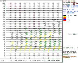
Figure 1a
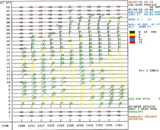
Figure 1b
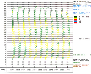
Figure 1a
Figure 1a-c. VAD Wind Profile 8 July 1996 a) 1102-1200
UTC b) 1206-1304 UTC c) 1304-1402 UTC
3. DISCUSSION
At 1200 UTC an outer rainband was over the east coast of Puerto
Rico. The rainband had bow echoes embedded in it similar to mid-latitude
mesoscale convective complexes. The band had sharp low-level reflectivity
gradients along the leading edge and maximum reflectivities 50-54
dBZ. Rotating heads and rear inflow notches (RINs) were visible
in a large broad bow. At least three rear inflow notches (RINs)
appeared in the reflectivity data over the ocean north of Puerto
Rico in the rainband. Rotating heads appeared to be present with
the smaller scale bows and suggested the locations of mesoanticyclones.
VIL values were 12 kgm-2 or less in the rainband and maximum echo
tops 20,000-25,000 ft. Maximum reflectivities of 50-54 dBZ were
confined to 9,000 ft or less. Maximum echo top data suggested the
convection producing the bow echoes was low top in nature, generally
less than 30,000 ft. A trailing band of stratiform precipitation
was observed east of the bow echo.
Between 1200 UTC and 1419 UTC, the outer rainband progressed past
San Juan toward western Puerto Rico. Figure 2 shows a bow echo embedded
in a rainband of Hurricane Bertha as it crosses the north coast
of Puerto Rico on 8 July 1996. A well defined bow echo with maximum
reflectivities of 50-54 dBZ, a RIN, and subtle hook echo are visible
at 1310 UTC before weakening by 1414 UTC.
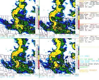
Figure 2. Four-panel Base Reflectivity time
series at 0.5° elevation for the period 1304UTC (upper left)
- 1321UTC (lower right) on 8 July 96
Another portion of the initial rainband (north of the coast) discussed,
began bowing southeast from the Atlantic toward northwest Puerto
Rico. By 1419 UTC an incipient bow echo was over northwest Puerto
Rico and had increased in maximum reflectivity to 50-54 dBZ. VIL
values were 14 kgm-² or less. A RIN present east
of the developing bow echo at 1419 UTC expanded and progressed into
the bow. From 1425 to 1431 UTC a subtle hook and, or mesocyclone
was suggested by the reflectivity data near Mayaguez. Unconfirmed
reports of a tornado were received from the Mayaguez area in the
morning. Examination of base reflectivity data for 1425 UTC indicated
a shallow core to the bow echo, 35-39 dBZ limited to below 22,000
ft. VIL values in the bow echo were 12 kgm-2 or less. Maximum echo
tops were only around 20,000-25,000 ft. Other storms in the rainband
north of the coast exhibited subtle bow echo features also.
Figure 3. Shows the SRM data corresponding to
the low-level reflectivity data. Examination of this data confirms
the existence of features normally associated with bow echoes, such
as a RIN, and suggests mesocirculation features were also present
in the outer rainband. Further diagnosis of SRM data for the period
1304 UTC to 1414 UTC showed weak mesocyclonic and mesoanticyclonic
areas of shear associated with the bow echoes. Maximum outbound
velocities of 10-21 kts and maximum inbound velocities of 22-29
kts occurred between 1316 and 1321 UTC.
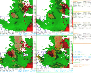
Figure 3. Four-panel Storm Relative Velocity
map time series at 0.5° elevation for the period 1304 - 1321UTC
on 8 July 1996
From 1356 to 1414 UTC, velocities and shears gradually weakened
in the original bow echo which had moved over western Puerto Rico.
The acceleration of the portion of the rainband north over the Atlantic
Ocean continued southeast into northwest Puerto Rico. By 1414 UTC,
outbound velocities east of the new bow echo had increased from
10-21 kts to 22-29 kts. Weak subtle areas of shear began to develop
on the north and south ends of the concave shaped echo.
Outbound velocities peaked at 22-29 kts over western Puerto Rico
immediately east of the evolving bow echo at both 1419 and 1431
UTC. Subtle areas of meso -anticyclonic shear on the north end and
mesocyclonic shear on the south end of the bow echo increased. Inbound
velocities at both ends of the bow echo peaked at 22-29 kts. The
radar beam was likely overshooting much of the low-level outflow
air with a beam height of 9,000-10,000 ft. By 1437 UTC, the bow
echo had begun to dissipate.
4. SUMMARY AND CONCLUSIONS
WSR-88D data indicate that bow echoes are more frequent in hurricane
rainbands over the Caribbean than previously thought. Examination
of the data revealed more than one occurrence of bow echoes in the
outer rainbands of Hurricane Bertha.
Bow echoes observed in Hurricane Bertha's outer rainbands were
more similar in structure and environmental conditions to that found
in cool season mid-latitude bow echo events than to warm season
mid-latitude events. Low echo tops and VILs, and limited vertical
extent of the high reflectivity cores provided strong evidence of
weak updrafts in the rainbands, which is similar to earlier findings
of research on tropical cyclones. These structural features are
opposite of those found for warm season bow echo events at mid-latitudes.
Environmental parameters, marginal instability and higher sr helicity,
also conformed to the conditions found present in cool season bow
echo and tornadic hurricane events.
Finally, topography and wind direction appear to be key factors
in the formation and longevity of bow echoes in Puerto Rico. Mountainous
terrain and wind direction on the island likely affected storm type.
Most days convection over the island appears to be pulse type storms,
but the bow echoes in the outer rainbands on 8 July 1996 had features
more common to HP supercells.
5. ACKNOWLEDGEMENTS
The authors wish to thank Rachel Gross for reading the manuscript
and suggesting helpful changes.
6. REFERENCES
McAdie, J. C., P. Dodge, and S. H. Houston, 1995: Mesoscale features
of Tropical Storm Beryl (15-16 August 1994) as detected by the WSR-88D.
Preprints, 21st AMS Conf. on Hurricanes and tropical Meteorology.
Miami. FL, Amer. Meteor. Soc. 320-322.
Jorgensen, D.P., 1984: Mesoscale and convective-scale characteristics
of mature hurricanes. Part 1: General observations by research aircraft.
J. Atmos. Sci., 41, 1268-1285.
Korotky, J., J.R. Michael, and C.E. Williford, 1995: Tropical Storm
Beryl: A WSR-88D Radar Overview. Preprints, 21st Conf. on Hurricanes
and Tropical Meteorology. Miami, Fl, Amer. Meteor. Soc.
Parrish, J. R., R. W. Burpee, F. D. Marks, JR., and R. Grebe, 1982:
Rainfall patterns observed by digitized radar during the landfall
of Hurricane Frederic (1979). Mon. Wea. Rev., 110, 1933-1944.
Powell, M. D., P. D. Dodge, and M. L. Black, 1991: The landfall
of Hurricane Hugo in the Carolinas: Surface wind distribution. Wea.
Forecasting, 6, 379-399.
Przybylinski, R.W., T. J. Shea, D. L. Ferry, E. H. Goetsch, R.
R. Czys, N. E. Wescott, 1993: Doppler Radar Observations of High-Precipitation
Supercells over the Mid-Mississippi Valley Region. Preprints, 17th
Conf. Severe Local Storms, St. Louis, Amer. Meteor. Soc., 158-163.
* Corresponding author address:
|

 National Weather Service Forecast Office