
|
|
| You are here: NODC Home > Access Data > Buoy Home |
Use text links below or click on area of interest in the map.
Region: |
NOAA Marine Environmental Buoy Database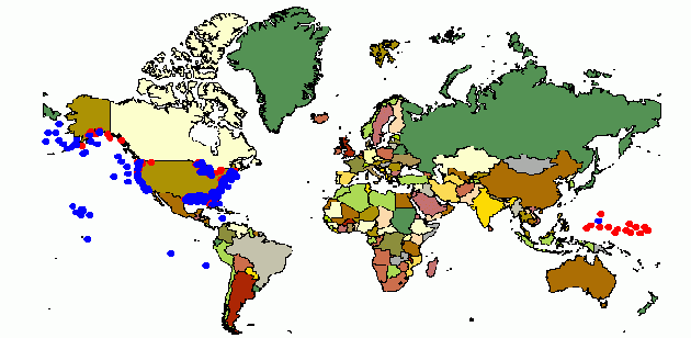
The NOAA Marine Environmental Buoy Database (NODC File 291) is one of the largest and most frequently used data archives maintained by the NODC. This database holds wind, wave, and other marine data collected by the NOAA National Data Buoy Center (NDBC). The data are collected from NDBC moored buoys and from C-MAN (Coastal-Marine Automated Network) stations located on piers, offshore towers, lighthouses, and beaches. Parameters reported by both buoys and C-MAN stations include air temperature and pressure, wind speed and direction, wind gust, and sea surface temperature. The buoys (and a few C-MAN stations located on offshore towers) also report wave data, usually including wave height, wave period, and wave spectra. Since the late 1980s some buoys have reported directional wave spectra. NODC receives the data from NDBC on a monthly basis, generally 2-3 weeks after the last observation from the given month, and makes them available online. The above interactive map and related files provide users with detailed information about the positions, period of record and other characteristics of the data in this NODC database. The NOAA Marine Environmental Buoy Database (only through December 1997) is available on CD-ROM from the online store or via User Services. However, all F291 Buoy Data in the NODC archive may be downloaded through this system. Note: file sizes range from 50 Kbytes to 1.4 Mbytes compressed (300 Kbytes to 5.5 Mbytes uncompressed).
Number of "Buoy Months" in the Archive is 35786. (Last updated September 10, 2008) Note - two buoys 46023 and 46062 have associated id's, 46b23 and 46b62. The b data files contain observations taken by acoustic Doppler current profilers (ADCPs). Data records A (Descriptive Header Record) and E (Subsurface Current Data Record) are used in the files. The "new" buoy id's are treated like all other buoys in that they have their own inventory pages. NOAA Marine Environmental Buoy Data (F291) General Information
If you are interested in being notified whenever this page is updated, send a brief note to Thomas Ryan (Thomas.Ryan@noaa.gov) and ask to be added to the mailing list for the NOAA Marine Environmental Buoy Database. |
| Last modified: Wed, 10-Sep-2008 12:43 UTC | NODC.Webmaster@noaa.gov | ||
|
Freedom of Information Act (FOIA)
USA.gov - The U.S. Government's Web Portal
|
|||