Helene made landfall as a minimal tropical storm near Fort Walton Beach,
Florida and redeveloped into a strong tropical storm over the North
Atlantic.
a. Synoptic History
Helene developed from a tropical wave that emerged from the African coast on
10 September. The wave lost all of its deep convection the next day as it
continued moving westward. There was little sign of redevelopment until 14
September when convection formed near the center of the system. Showers and
thunderstorms continued overnight and Dvorak satellite estimates indicate
that Tropical Depression Twelve formed on the afternoon of the 15th.
The depression appeared to weaken before aircraft reconnaissance first flew
into the system the next day. The aircraft could not find a closed
circulation, indicating that the depression had degenerated into a tropical
wave. It is notable that, even without any center, the plane reported winds
in excess of 55 knots at 1500 ft to the north and east of the wave.
The remnants of the depression moved over the Leeward Islands on the
17th, producing heavy rains and gusty winds to tropical storm
force in squalls. Upper-level conditions seemed very favorable for
regeneration, but the system was slow to redevelop. It was not until late on
the 19th that a reconnaissance aircraft found a closed circulation
northwest of Grand Cayman Island, while the system was moving more to the
west-northwest. The depression was very weak with only a few thunderstorms
near the center when it crossed the western tip of Cuba the next day.
However, convection redeveloped near the center and it became Tropical Storm
Helene early on the morning of the 21st in the southeast Gulf of
Mexico. The storm moved northwestward, strengthening under marginally
favorable conditions. However, the vertical wind shear increased,
preventing Helene from attaining hurricane status. The system became very
asymmetric as a result of the shear, with most of its deep convection,
winds, and heavy rainfall displaced to the east of the center. It peaked at
a maximum intensity of 60 knots about twelve hours before landfall. The
shear increased further and weakened Helene to an intensity of 35 knots
during landfall near Fort Walton Beach, Florida around 7 am CDT on the
22nd. Helene then moved toward the northeast over the
southeastern states as a tropical depression.
Even with strong westerly shear, deep convection began to intensify over the
coastal waters of North Carolina when the system approached the east coast.
Tropical storm force winds were measured at stations off the coast of North
Carolina. A post-analysis of buoy data and satellite imagery indicates that
Helene had developed enough tropical characteristics to be considered a
tropical cyclone as it emerged from the coast of Virginia. The cyclone began
to race northeastward away from the United States toward decreasing shear.
Ship observations and satellite images indicate the system was very compact
over the Atlantic, no more than 120 n mi wide with the strongest winds in
the south and east quadrants. An intense burst of convection formed over the
center on the 24th, and it is estimated that Helene reached a
second peak intensity of 60 knots early on the 25th before merging
with a cold front later that day. The best track is listed in Table 1 and
is plotted in Figure 1.
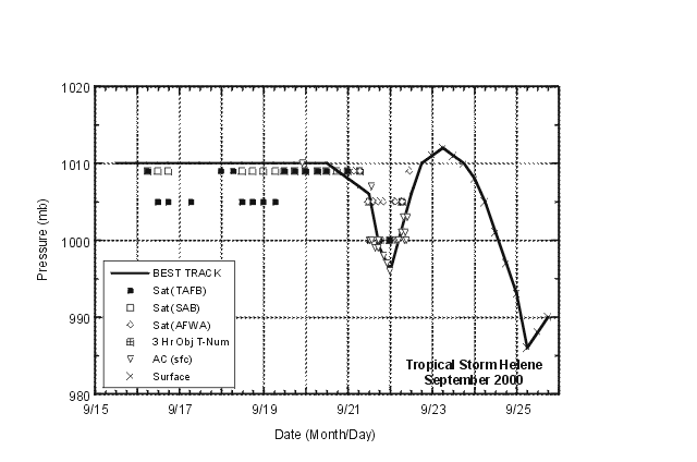
b. Meteorological statistics
Figure 2 and Figure 3
shows the best track curves for maximum sustained 1-min surface
winds and minimum central pressure data, respectively, as functions of time.
These plots include aircraft reconnaissance, Dvorak satellite classification
estimates, and surface observations. Table 2
includes selected surface observations along the path of Helene. The
intensity or redevelopment of Helene as it emerged off the Mid-Atlantic
coast would likely never have
been known if not for the hourly reports of the ship Neptune Olivine.
The ship reported sustained winds of 56 knots at 0600 UTC on the
25th as the storm moved nearby. An intensity of 60 knots has been
estimated from this ship report. The ship also recorded a lowest pressure
of 988.2 mb with a westerly wind of 46 knots. However, it is likely that
the ship did not report the minimum pressure as the winds indicate that the
ship was displaced to the south of the center and a final estimate of 986 mb
has been made. It is notable that Neptune Olivine had reports that
were similar to another ship to its southeast, the Global Mariner,
that reported sustained winds of 52 knots at the same time that the
Neptune Olivine reported 56 knots.
Figure 4 displays the hourly wind and pressure data
reported by the Neptune Olivine.
c. Casualties and damages
The one casualty associated with Helene was a man killed in a F2 tornado in
South Carolina as the tropical depression moved through the region on the
23rd. The storm caused extensive flooding in Tallahassee, Florida
where it dumped near nine inches of rain.
d. Forecast and warning critique
Despite the apparently favorable conditions for tropical cyclone
development: low shear, enough convection, low pressure, warm ocean, and
high ocean heat content, the depression did not strengthen until after it
entered the Gulf of Mexico. The expected strengthening from the official
forecast as well as the intensity guidance prompted tropical storm watches
and warnings for some of the eastern Caribbean Sea islands and then for
western Cuba. Once Helene formed in the Gulf of Mexico, watches and
warnings were issued for a portion of the northeast Gulf coast.
Table 3
includes a watch and warning summary. The final official forecast issued on
Helene indicated the possibility of restrengthening over water as an
extratropical system. However, the post-analysis
indicates that system retained tropical characteristics.
Operationally, Helene was a tropical storm for 36 hours only. Therefore, no
forecast verification statistics are presented. It is worth noting that, in
general, track models correctly captured the westward motion of the system
through the Caribbean and the gradual northward turn over the Gulf of
Mexico.
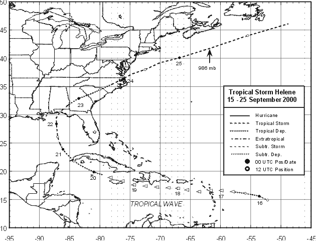
Figure 1.
Best track positions for Tropical Storm Helene, 15-25 September, 2000.
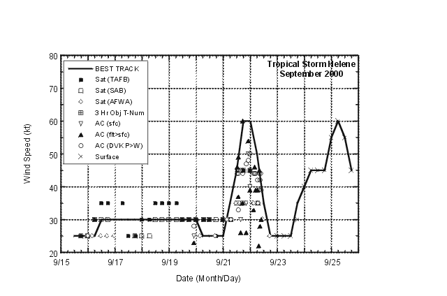
Figure 2.
Best track maximum sustained wind speed for Tropical Storm Helene, 15-25 September, 2000.

Figure 3.
Best track minimum central pressure for Tropical Storm Helene, 15-25 September, 2000.

Figure 4.
Hourly wind and pressure reports from vessel Neptune Olivine from 00 to 10
UTC 25 September 2000.
Table 1.
Best track for Tropical Storm Helene, 15-25 September, 2000.
Date/Time
(UTC) | Position |
Pressure
(mb) |
Wind Speed
(kt) | Stage |
| Lat. (°N) | Lon. (°W) |
| 15 / 1200 | 14.9 | 52.2 | 1010 | 25 | tropical depression |
| 15 / 1800 | 15.3 | 53.0 | 1010 | 25 | " |
| 16 / 0000 | 15.6 | 53.6 | 1010 | 25 | " |
| 16 / 0600 | 15.8 | 54.4 | 1010 | 25 | " |
| 16 / 1200 | 16.1 | 55.9 | 1010 | 30 | " |
| 16 / 1800 | 16.4 | 58.0 | 1010 | 30 | tropical wave* |
| 17 / 0000 | 16.6 | 59.9 | 1010 | 30 | " |
| 17 / 0600 | 16.6 | 61.7 | 1010 | 30 | " |
| 17 / 1200 | 16.4 | 63.6 | 1010 | 30 | " |
| 17 / 1800 | 16.7 | 65.6 | 1010 | 30 | " |
| 18 / 0000 | 17.0 | 67.1 | 1010 | 30 | " |
| 18 / 0600 | 17.1 | 68.7 | 1010 | 30 | " |
| 18 / 1200 | 17.2 | 70.6 | 1010 | 30 | " |
| 18 / 1800 | 17.4 | 72.5 | 1010 | 30 | " |
| 19 / 0000 | 17.6 | 74.4 | 1010 | 30 | " |
| 19 / 0600 | 18.3 | 76.3 | 1010 | 30 | " |
| 19 / 1200 | 18.9 | 78.3 | 1010 | 30 | " |
| 19 / 1800 | 19.4 | 79.6 | 1010 | 30 | tropical depression |
| 20 / 0000 | 19.9 | 81.0 | 1010 | 30 | " |
| 20 / 0600 | 20.7 | 82.6 | 1010 | 25 | " |
| 20 / 1200 | 21.8 | 84.3 | 1010 | 25 | " |
| 20 / 1800 | 23.0 | 85.4 | 1010 | 25 | " |
| 21 / 0000 | 23.9 | 86.1 | 1008 | 25 | " |
| 21 / 0600 | 24.9 | 86.6 | 1007 | 35 | tropical storm |
| 21 / 1200 | 26.1 | 87.0 | 1006 | 45 | " |
| 21 / 1800 | 27.1 | 87.1 | 999 | 60 | " |
| 22 / 0000 | 28.4 | 87.2 | 996 | 60 | " |
| 22 / 0600 | 29.5 | 87.2 | 1001 | 50 | " |
| 22 / 1200 | 30.5 | 86.6 | 1006 | 35 | " |
| 22 / 1800 | 31.6 | 85.4 | 1010 | 25 | tropical depression |
| 23 / 0000 | 32.9 | 83.5 | 1011 | 25 | " |
| 23 / 0600 | 33.6 | 81.7 | 1012 | 25 | " |
| 23 / 1200 | 34.4 | 80.0 | 1011 | 25 | " |
| 23 / 1800 | 35.4 | 78.0 | 1010 | 35 | tropical storm |
| 24 / 0000 | 36.4 | 76.1 | 1008 | 40 | " |
| 24 / 0600 | 37.2 | 74.7 | 1005 | 45 | " |
| 24 / 1200 | 38.0 | 72.5 | 1001 | 45 | " |
| 24 / 1800 | 39.2 | 70.1 | 997 | 45 | " |
| 25 / 0000 | 40.1 | 66.8 | 993 | 55 | " |
| 25 / 0600 | 41.6 | 62.2 | 986 | 60 | " |
| 25 / 1200 | 44.0 | 55.5 | 988 | 55 | " |
| 25 / 1800 | 46.1 | 48.8 | 990 | 45 | " |
| 26/ 0000 | | | | | absorbed by a front |
| |
| 25 / 0600 | 41.6 | 62.2 | 986 | 60 | minimum pressure |
| 22 / 1200 | 30.5 | 86.6 | 1006 | 35 | Landfall near Fort Walton Beach, FL |
*estimated location of the cloud system center tracked by satellite
Table 2.
Tropical Storm Helene, selected surface observations, September, 2000.
| |
Minimum
sea-level
pressure |
Maximum surface wind speed
(kt) |
|
| Location |
Press.
(mb) |
Date/
time
(UTC) |
Sust.
winda
(kts) |
Peak
gust (kts) |
Date/
timeb
(UTC) |
Storm
surgec
(ft) |
Storm
tided
(ft) |
Rain
(storm total)
(in) |
| Lesser Antilles |
| Guadeloupe (TFFR) | | | | 48 | 17/Unk. | | | |
| Antigua | | | | | | | | 3.14 |
| Gulf of Mexico Buoys |
| 42003 | | | 32 | 39 | 21/1049 | | | |
| 42039 | | | 31 | 41 | 22/0043 | | | |
| Florida |
| Perdido Key | | | 20 | 34 | 22/0730 | | | |
| Panama City Beach | | | 23 | 39 | 22/0900 | 1 | | |
| Pensacola Beach | | | 23 | 38 | 22/0930 | 1 | | |
| Destin Airport (DTS) | | | 24 | 35 | 22/1118 | 1 | | |
| Cape San Blas CMAN | | | 26 | 46 | 22/1211 | | | |
| Apalachicola (KAAF) | | | | | | | | 9.56 |
| Sopchoppy | | | | | | | | 9.50 |
| Tallahassee (KTLH) | | | | | | | | 7.86 |
| North Carolina |
| Frying Pan Shoals CMAN | | | 40 | 47 | 23/1825 | | | |
| Cape Lookout CMAN | | | 36 | 45 | 23/1902 | | | |
| Duck Pier CMAN | | | 38 | 45 | 23/2215 | | | |
| Diamond Shoals CMAN | | | 51 | 61 | 23/2243 | | | |
aASOS and CMAN's are 2-minute averages, buoys are 10
minute averages, all others are 1-minute averages.
bDate/time is for wind gust when both sustained and gust
are listed.
cStorm surge is water height above normal astronomical
tide level.
dStorm tide is water height above National Geodetic
Vertical Datum (1929 mean sea level).
Table 3.
Watch and warning summary, Tropical Storm Helene, September, 2000.
Date/Time
(UTC) |
Action |
Location |
| 16/0300 |
Tropical storm watch issued |
St. Maarten, Saba, St. Eustatius |
| 16/0900 |
Tropical storm watch issued |
Antigua, Anguilla, Barbuda, Montserrat, Nevis, St Kitts |
| 16/1700 |
Tropical storm watch discontinued |
St. Maarten, Saba, St. Eustatius, Antigua, Anguilla, Barbuda, Montserrat, Nevis, St Kitts |
| 20/0300 |
Tropical storm warning issued |
Cuban provinces of Isle of Youth, Havana, Pinar Del Rio, and the city of Havana. |
| 20/1500 |
Tropical storm warning discontinued |
Cuban provinces of Isle of Youth, Havana, Pinar Del Rio, and the city of Havana. |
| 21/1500 |
Tropical storm warning issued |
The mouth of the Pearl River on the Louisiana-Mississippi border eastward to the mouth of the Aucilla River, Florida |
| 21/2100 |
Hurricane watch issued |
The Florida-Alabama border eastward to the mouth of the Aucilla River, Florida |
| 22/0300 |
Tropical storm warning discontinued |
The mouth of the Pearl River on the Louisiana-Mississippi border eastward to west of Pascagoula, Mississippi. |
| 22/0900 |
Hurricane watch discontinued |
The Florida-Alabama border eastward to the mouth of the Aucilla River, Florida. |
| 22/1500 |
Tropical storm warning discontinued |
Pascagoula, Mississippi eastward to just west of Destin, Florida |
| 22/1800 |
Tropical storm warning discontinued |
Destin, Florida eastward to the mouth of the Aucilla River, Florida |
![[NCEP Logo]](graphics/ncep.gif)