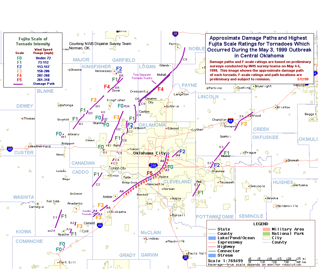
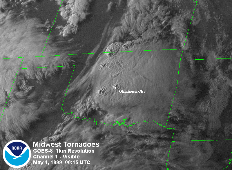
Devastating tornadoes hit portions of Oklahoma and Kansas on Monday evening May 3rd, 1999. The estimated death toll stands at 49 people, 44 of the fatalities in Oklahoma and five in the Wichita, Kansas area. Additionally, the same storm system resulted in one death in Texas and four deaths in Tennessee, bringing its total to 54. The largest tornado (F-5) on the Fujita-Pearson Tornado Scale formed about 45 miles southwest of Oklahoma City and cut a path at least a half-mile wide as it moved north and east across the Oklahoma City area, staying on the ground for about 4 hours. This photo from the newspaper, "Daily Oklahoman" shows detailed Aerial Tornado Damage. Preliminary estimates show that 76 tornadoes occurred during the event across the southern plains states. Oklahoma officials now estimate that 8093 homes or businesses were damaged or destroyed; while Kansas estimates 1109 homes or businesses were destroyed. A track map courtesy of the NWS Disaster Survey team Central Oklahoma Tornado Track Map shows the approximate damage paths and highest Fujita scale ratings for tornadoes occurring in Central Oklahoma on May 3rd, 1999. The insurance industry expects insured losses to reach or exceed $1 billion.
The storm system also produced heavy rainfall in portions of Oklahoma, Kansas, Missouri, and Arkansas. The following file provides preliminary rainfall totals related to this storm system -- Rainfall Data. Seven locations reported over five inches of rain, and some isolated flooding occurred.
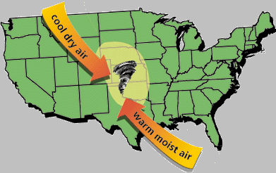
The central part of the U.S. is traditionally known as ""Tornado Alley". This "alley" covers the states from Texas northward to the Dakotas. This part of the country experiences a unique combination of geography and climate which enhances severe weather events. Dry air flowing eastward from the Rockies meets the warm, moist air flowing north from the Gulf of Mexico, and cooler air flowing southward from Canada. These atmospheric ingredients fuel violent thunderstorms which spawn tornadoes. Springtime is prime time for violent deadly tornado outbreaks in this part of the U.S., and these outbreaks are part of the climate pattern of the U.S. A continuing major challenge is increasing prediction skills and lead times before these events occur. The above map depicts the average annual number of tornadoes per 10,000 square miles. Note that the highest incident number of tornadoes occurs in Florida with Oklahoma ranked second. Additional tornado climatology maps are available from NCDC Tornado Climatology Maps for the U.S.
As of noon on 5/13/99, Mount Baker, Washington set a new "unoffical" world snowfall record with 1124 inches of snow recorded this season. The snow fell between November 1st, 1998 and noon on May 13th, 1999. The official snowfall season runs from July 1st through June 30th. This amount of 1124 inches or 93.67 feet surpasses the previous record of 1122 .5 inches received at the Rainier-Paradise NWS cooperative station during the 1971-1972 season. Mt. Baker's record is currently "unofficial" until the National Climate Extremes Committee can complete a review of the new reported record. The committee run by the National Oceanic and Atmospheric Administration (NOAA) is working with the Mt. Baker ski area to begin the evaluation process. Mt. Baker ski area records snowfall at an elevation of 4,300 feet and Paradise records snowfall at an elevation of 5,420 feet.
The Mt. Baker ski area also set a record for most snow recorded during one winter season. Between November 1, 1998 and April 30, 1998 Mt. Baker received 1,096 inches of snow beating the Rainier-Paradise record of 1,038 inches set in the November 1971-April 1972 season.
Outside the U.S., drought continues in portions of Mexico, New Zealand and North Korea. The drought in Mexico has caused the government to declare disaster zones in nine states, these states are eligible to receive emergency funds to cope with one of the worst dry seasons this century. The Mexican Interior ministry said 396 municipalities were affected by the prolonged dry season, and the problem of supplying water to some of them was becoming acute. In some areas the drought is entering its fifth year, and officials say one third of the entire country is affected. Drought problems in Somalia are compounded due to several years of bad harvests.
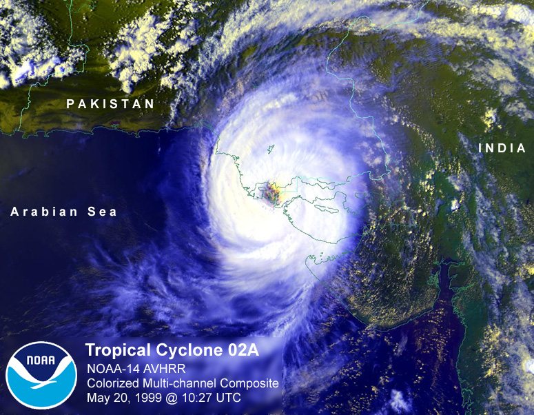
A heat wave continued across portions of India and Pakistan during the beginning of the month but on May 20th, powerful cyclone 02A (satellite image) with 170 MPH winds hit portions of southeast Pakistan and the extreme west coast of India, wiping out hundreds of villages - CNN Special Cyclone Report. Flooding is also causing problems in Austria and Thailand and across portions of the Rhine in France and Switzerland. CNN European Flooding Report.. Details of these and other global extremes can be found at the following NOAA/OGP Special Global Summary for May 1999.


